Typhoon Tip
-
Posts
44,477 -
Joined
-
Last visited
Content Type
Profiles
Blogs
Forums
American Weather
Media Demo
Store
Gallery
Everything posted by Typhoon Tip
-
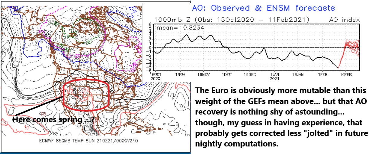
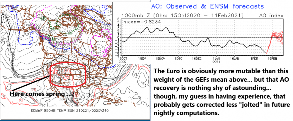
Hopefully you're kidding ..but gosh no - no, the use of those products is more symbolic. They are 'hints' that a warmer regime "might" be formulating and given time, it may bust through the dying AO proxy on the flow. Which I think the it's been heavily influencing above ~ 50 N much of the winter. It seems the blocky nature up N is in a weird incongruity wrt to the fast paced progressive flow sliding by underneath to the S. The hemisphere appears unusually strongly split between the Ferrel latitude circulation type ( roughtly above 50 N ...), vs the lower latitudes where the expanded HC is being compressed and we are seeing velocities/ progressive tendencies along the interface - not sure what your level of understanding/background is... but that's all more so than less, observably defining this winter to me. We don't typically see west limb -NAO blocking nodes with 140kt 500 mb jet streams blowing from Frisco to London underneath - that's unusual..
-
I do wonder though.. could that be sign of an end to this winter - just an early speculation here. Not all at once per se ..but that's the turner - This year smacks as not being like the last several, where there was onset NAOs that crippled Aprils and May for warmth. Granted, it's only entering mid Feb but usually - in my experience - when the Earth wants to do a region a different idea it starts hinting its coming. These are like those hints to me ( blw ), but they are hints I am intrigued by because we have ( La Nina spring climo + HC expansion ) and those two, together, are a bit of a constructive interference behind this spring's pattern. Whenever we get into that sort of "emergent" resulting stuff, the 'rogue' wave effect comes into play; we don't know if the synergistic result end up more than the sum of the individual players - by definition of course... Mapping those too effects over each other ...this could all end in a hurry, and it may not be a good spring for March snow. Or ..lol... watch, it'll be a +10 March with a single two day 30" bomb that has nothing to do with blocking - ... Kidding, but blocking or not, 'canon ball season'
-
Prolly not a bad early guess/correction based upon seasonal success/ ... returns. We've had a two "big ones" - tho that is subjective ... whatever ... otherwise, it's been a nickle-dime diet.
-
You're right about the confluence and attending +PP ( pressure pattern...) offering huge BL resistance ...such that the low can't .. blah blah blah ... we end up in that EPS sort of set up But I'm being ignored of an entirely different aspect, one that is empirical and not merely a sentiment or anecdotal. It's not the best news for storm enthusiasts so ... heh. Go wonder - everything is proving over-assessed, correcting weaker ... with greater frequency. Snow? OKAY, well ...if it weakens enough ... it won't do that either. I don't ?think? it will weaken that far... But, I lean toward a minoring event until such time as this gets continuity at < than 120 hours. so we'll see
-
That "phasing" you are detecting in some of these 'lesser' dependable guidance types are, in spirit, really honing the original 11th - 15th .. 17th period of risk I was trying to elucidate a while ago... The models are proving that was valid in my estimation - the total atmospheric space is just not 'capable' - for lack of better word - in maximizing it so we get those less than proficient variations like that weird positive tilted version by the GGEM. What we have is a favorable Canadian deep layer set up ... but the PNA --> PNAP aspect isn't ( apparently ...) cooperating. The GEFs back whence carried (...and in fact still do as of last night's EOFs) on with a concerted rise in the PNA ...so therein was justified speculation that we may see a better western ridge response. Nope f! just missed huh. - it's like a prodigal kid with all kinds of potential hangs out with the wrong crowd and disappoints the community. haha... Sometimes gifts and affluence are wasted.. But up N...there are blocking blips decaying and they tend to rotate S in the ongoing integral large synoptic circulation/climo, but the the coupled/ subtended ( latitude...) SPV fragments are held in stasis in wait... That's a favorable canvas whether it gets used in a subsume / .. drop in capture cirque Du Soleil scenario or not.. Usual, Pac wave squirts through the westerlies and on it's heel the rising PNA ( actually f'ing happens - christ ) and sends a +PNAP jolt across the continent - those breakdown said stasis and the whole structure collapses S, and our poor S / stream wave had no clue what was about to befall it - lol...
-
Don't ignore the fact that it's a "mere" 2 mb weaker - not that you are just sayn'
-
But what form does it take? ... this winter has carried about with an insidious under-the-radar propensity for ever diminishing returns.. I'd say perhaps less insidious now because it's pretty obvious at this point. If/when the GGEM brings it back ... it'll likely be some pallid representation of what it originally was in/when it was first detected in the model's deeper field extended range - I mentioned this a couple of times and am hoping - probably futilely .. - for folks to take it seriously. The models are consummately correcting just about everything passing through the middle range, morphing them into less mechanical presence ( 'normalizing' in statistics and physical vernacular) in the general ambience. It almost doesn't seem to matter what it is... I like the metaphor. Seeing the moon toeing its way over the eastern horizon on a clear evening, it's looming so large as to portend an impending planetary collision. Only to rise higher into the sky and as it comes into a realistic focus and it is far less imposing. The models seem to first detect events and features hugely at the edge of their 'frames of reference,' - perhaps as a seasonal bias that is endemic to this type of general hemispheric circulation's situational anomalies ... don't know, but it is definitely a repeating pattern of corrective behavior. This thing for the 17th is doing exactly the same thing... rinse repeat ... The GFS has flattened it like 9.8% per run, across the last 3 cycles ... It'll come back a couple of 9.8's ..but then enfeeble another series ...until in the end we arrive to an over-warned ordeal ... like going to a meet up with a Tindr profile that proves she had 'er junk Photoshopped - Before continuing ... this does not mean a dystopian cryo -bomb of deadly proportions is not going to happen... So, keep one's e-psychotropic-heroine needles sterilized... Should 1978 walk through the door with the advantages of modern CC PWAT to push the 50" contour out to Orange Massachusetts ... I don't want that to diminish the significance of the this snark.
-
mm. nor will the GFS for that matter ... on that date - I give the model credit though for sensing the weight/ .. inhibition of the BL cold in keeping the lower reflection of that thing well S where the baroclinic field is.. When I saw both the 12z and 18z I thought fo' sho' the 500 mb was gonna run a low up the St Lawrence SeaWay ...but, man - ever seen that much negative tilt that far west (BUF!) and a low 100 mi S of Cape Cod ?? It's like the DPVA out there only has an inverted trough and some piece of shit thundertorm vort turd generates a 999 mb low... The funny thing is, ..that curls up a pretty good dose of WAA/ pwat air from the deep south...so that whole things is as much isentropic lift as it may be trying to formulate a coastal low.. . But, if this flow tends to flatten a little and that neg tilt out there were to come farther E and start collocating it's exit/entrance jet mechanics over that hood of that coastal shit I'm telling you the sucker is drilling hole through the planet - Not impossible... just waiting for your boarding pass and seating assignment fulfillment disappearing over the western horizon
-
Good point - lol
-
Plus ...10 years ago I knew some who live(d) in that area down there and were warning to bar- the windows of your car - not just alarm the vehicle... heh. Crime and recidivism therein was running amok ...don't walk alone late at night either. is that still like that? But it's true about the real-estate greed tsunamis curling over the horizon from the east. It follows the Earthquake of demand...and as demographics expand and layouts took over places like Acton to Sudbury and Littleton ...the between 495 and 128 region during the late 1970s through 2000, the 'ring' over development moved west. Everyone along or east of that boundary ...goes from too much for housing to down right amoral economy - If you prorated every solid state material in a house on Arlington Heights... the nails are 1,000 bucks a pop ... kidding but point taken. I live in a small house I bought here in Ayer ....too many years ago. I never intended to live here this long. I thought I'd had saved and moved up salary-wise, ...met a nice women... all that. I'm still here ... eh hm, but, about 5 years ago, I started getting these texts if not phone calls from random inquiries. "High, we're real-estate developers interested in your area - is there any interest or are you considering a relocation and seeking a way out of your mortgage" - come to find, Ayer's housing market has appreciated some 35% in these 10 years... I mean, I have fixed this house up when I could afford. But man, even small-ish projects get into the Ben Franklyn''s pretty fast - if you gotta replace a window...and the frame is rotten, it's like 1200 boom. I replaced the back roof -was supposed to be a shingle replace, but the guy put his toot through it and "strongly" recommended new ply - so... it's smaller scaled roof...still... ended up being 4500... Then the foundation field stones had to be repointed ...and that ended up with a girder system... 7500... I did the floors to make girls like want to actually enter the home - it didn't work.. but, that ran 2200 ... I mean this shit adds up... wait what am I talking So anyway these outfits want to buy this property outright cash... but I'm in limbo between continuing to fix it and doing that and getting out of Ayer and selling it for more if I can. I don't have anything about this town that I hate, but this house is next to a main rail for both freight and commuter... I mean, it's right there out the window across the street. Can do without the coupling 100,000 tons of steal thunder and the bed rocking at 3am... Least I know I can get out of this mortgage probably at any time...and even make a small amount.
-
mmm.. gonna have to part company here ... haha. No thanks - In fact, I don't wanna keep any Greenland butt plug - f that! ... Besides, excluding my "super realistic" anachronistic desire to see winter end by March 15 and go 85 F ... It' proven over and over it's too much.
-
It's all fun... but, we still have to be vigil of the notion that as that range gets closer in time, models are consummately having to tone it down wrt to these bigger looks.
-
Not to get into details this far out ... but, like others have probably surmised since you posted this ... that's sort of a 2007 Dec wall event there... Ends as freezing rain for an hour to glaze as a protective shield over a foot of pow-pow. I remember that happened in Dec... I think 2010 ? too - we had a forecast for 4-6" snow with a entry temp around 20 F ...and some +PP still lurking up N ... I'm goin' ...ah, ooh -hmm... yeeeeeeah... We had about 10" of 15:1 and when I was driving to work in 1/4 vis down a barren 495 wondering what in the f my company was thinking haulin' us in to work, the car's dash therm was 14! So it goes to pingers, then to silver rain that just looked super cooled - haha. It crusted maybe .15" glaze... But I remember when I got home that evening, shoveling out the walk, the snow under the glazing cap was still powder. Weird - That's how you define a SWFE ... warm air loses ...that's the ballgame
-
there's a few on that list ...
-
It does ... absolutely - so.. maybe it is its only predator for time - As the curvature tensor of space achieves perpendicularity time asymptotically LIM's to zero. And at that particular zero, it is not 0 in the numeral sense. It is zero as in an unfathomability absence. Hence why physicist say, for all intents and purposes whatever lurks there no longer exists in the natural universe - so nothing effectively does. That's really just ... elegantly disturbing "actually" - haha I have a hypothesis about time, space and gravity ... It's not a hypothesis, more like Science Fiction - but its that kind of plausible Sci -Fi. Not like "Star Wars" couched in as Science Fiction but isn't. That kind of cinema is beautiful art, but is pure fantasy. Anyway, imagine the firmament and everything of reality it contains combined, all of it, is really just a synergism produced by a Quantum Mechanical engine. Metaphor, the movie projector, vs the movie it conveys. The movie ( our frames of referencing ) cannot be used to describe the projector, absolutely. That is why General Theory of Relativity and the physics of Quantum Mechanics ...cannot be reconciled ( used to explain the other ). When the equations are intermingled and solved, you end up with no-no's like 1/ 0 = infinity at the point of singularities ...or at instant prior to the "Big Bang." These are extremes where the "frame" breaks down, and reality ceases to exist - just like the physicists intimate above. Well it does... because, that is like passing back through the lens of the Quantum Mechanical 'projector' into the machinery that produced the image .. where has nothing to do with why you love your soul mate ... or why your soul mates evades you. Much less, why one feels hunger or ambition, happy or sad... to why their are planets, stars, galaxies and super clusters of galaxies that when super computers attempt to three- dimensionally facsimilate, what they illustrate in imagery is startlingly indistinguishable from a very high resolution nuclear tomographical layouts of a brain's nuero-tapestry. Once your perception is inside the projector ... the image no longer exists there.
-
You know ... its true. For all our mutual commiseration about that great dearth decade of all time ( although I've heard the 1950s give it a run for the money ... ), that is one aspect about the 1980s that it did perform ... cryo bombs Man, there were some cold invasions that decade that would point tits in Hades ... When I was 10 ...I had a paper route in Kalamazoo Michigan. One Sunday morning, delivering the Gazette .. which of course was triple the weight, the air temperature was 0 F in a swirl of dense pixie pall and winds gusting to 35 mph. The sun dim orb losing to sound of soul being sucked outta one's f'n eyes it was brutal- ...I remember I was crying when I got home. On a nice day in June, the Sunday paper bag had to be set down ever five houses - it's a wonder kids didn't end up with Scoliosis luggin' that inhumane thing around. So imagine dragging that thing in that condition... omg! I think it was 1981 or something... '79 or '82 ... 1980 ... There was not a lot of big snows but we had some school delays for cold alone ... in an era where/when students did not ever get snow days for any reason, whether it snowed or not- Nowadays? ha - ...fuggin joke man with the pussification of kids and society.... Canceling school based upon forecasts ...granted, those have improved, but even so... 4-6" low grade winter storm warning - only cause the local forecast office isn't quite sure ... - and the tickers roll across the bottom of televisions and 'urgent' notifications force through to phone coverage and it's party tiiiiime! I think it's a culture of finding time off at least excuse imagined ... inside a cloak of safety requirements... but I'm a cynical bastard or fun w eeeeeee
-
I grew up with that era's cinema ... with all those icons of the silver screen strutting and fretting their turns and terms upon the stage ... now never heard forever more ... vanquished by predatory time. I'll tell ya, it's one of the weirdest paradoxes of nature, time's claim on all that resides beneath the firmament ... perhaps one day the firm' itself. For every prey, there is a predator ... and these tend to be in balance. For if either fails the whole system collapses ... Yin and yang I suppose. But time? Time seems to be the only metric in emergence of reality that truly does not require said balance - It only feeds..
-
egads ... invest in frozen futures i geuss
-
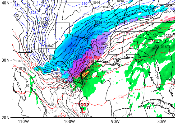
Does DuPage carry the 2-meter T's for this time ... ? Just curious cause the cold in that synopsis is - obviously .. - steeply sloped left in the sounding. I.e., it's probably colder than those contours/ .. perhaps neutral to the surface, in that advection region ..all the way down. I wonder if Brownsville could actually be flirting with 32 there ...
-
Didn't Will say he lived in Texas back then ?
-
And "as is" - always a risk ... - the operational GFS takes that mess into an Eastern Lakes as bully-primary... but the layout of the PP up over Ontario/ antecedent air mass in New England would argue that is - ironically - a major glazer here after the perfunctory snow to start type of climo thing - I would also still caution modeling 'over assessment' as an on-going contamination to performance -related issue with all guidance. I don't trust big heavy sprawling systems in that post 120 hour frames to actually succeed because of the punishing failures to actually do so ...doesn't lend much confidence - to put it drolly..
-
Take a moment to appreciate glazing at Brownsville Texas ? This has been a recurrent signal in the GFS runs ... this is actually the most striking it has been depicted, 120 hours from now .. the next frame after this as some mix that far that - ...that's pretty rare
-
I dunno, I think it snowed guys. Good lord with this neurotic nitpicking - it's now worse in lieu of some other style of delivery? LOL at the inconsolability ... - it snowed! I know ...I know... it wasn't evocative of enough excitement The 16th/17th is interesting ... Firstly, in the interest of fairness, the converging teleconnector signal appears to be failing to produce a correction event. In my defense, I did suggest the end point may extend out a bit longer. I mean, it's not like there are temporal boundaries on atmospheric events ...and being that far out there, who knows - That said, the 16/17 time range materializes from entirely different pattern morphology so ...I think in honesty it stands apart (causally...) It does not appear really at all by then to be related to the rising PNA, relaxing west-limb -NAO stuff. - these intervals are not always realized.. I know why in this case - strongly suspect I do ... The GGEM ( not a good model to me but just to make the case...), nicely shows the western end of the SPV failing to come down and capture/connect with the physical wave propagation of the intermediate stream out there later in the mid range. The culprit really appears to be wave propagation speeds .. The x-coordinate wave translation speed in the S, is too progressive ( fast ) wrt to the y-coordinate of the N (SPV) ... Thus it is not given enough time to move through the subsume process - meaning the S stream is outpacing the N/ streams ability to do so... So, we pass through that vulnerable period with shearing problems is what it really all boils down to.. But letting that go... the ~ 16th event's wave space/ mechanics are pure Pacific. As of the 00z's initialization ... said wave space's best discernible position in space is actual over the Sea of Japan!! It's that far ...yes, more literally than figuratively .... around the other side of the planet. And, is also all situated in the middle latitudes as a relay off the Asian continent. That feature is embedded in a tremendous accelerating wind tube along the underside of a very strong WPO vortex as it goes through some flexing ... moving forward in the modeling... and it squirts some 72 hours later near the Date Line... From there..it careens on nearly a flat flow trajectory through California by 120 hours... and 24 to 48 hrs later... "might" if it even exists, throw party up our way... Some cons ( you should be laughing a little at this point ...) : Flat progressive predictability is a bit of an oxymoron ... red flag. All season long, extended range and even many mid range systems are tending to mute as they get near in time. Lastly but surely not all .. .the hemispheric fast flow doesn't really promote curved trajectories in general ...so that does not lend to this thing, either. The pro is this is climo bomb time. The N stream does appear to relax... so, it is - speculative - possible the flow "decompresses" along the mid latitude heights more so than the model ar presently showing ... and that would emerge a better environment for purer Pacific waves to not be mooshed by the elephants ass of the N...
-
Clockwork dependable ... 14th muted as its relaying in from the extended
-
phew... right - no worries than .. lol - dates? don't come at me with human convention - I only have time for the Cosmos... Seriously though, I am actually flirting with the notion that things could break harder toward warm and pretty early this year. But we'll enjoy this month while it lasts. Not sure what your level of background is in this shit, but ... La Nina springs tend to be warmer. Also, the fast flow? That's the compression of the hemispheric winter heights against the 3-6 dm expanded HC that is not me ...it is scientifically and peer review vetted - I'm trying futilely to get people's eyes to stop rolling about the tropical expansion stuff, I know.. Anyway, both the LN and the HC are constructive interference ... So, when the -AO business and blocking stuff wanes out to neutral exerters ...those other two are sort of left in carte blanche as proxy over the general circulation eddy ... Just supposition