

Typhoon Tip
-
Posts
43,480 -
Joined
-
Last visited
Content Type
Profiles
Blogs
Forums
American Weather
Media Demo
Store
Gallery
Everything posted by Typhoon Tip
-
I say bide time on that. It’s been pulsing the ridge back-and-forth in that period. It keeps correcting that ridge reduction later in time too. EPS mean and GEFs Telecon layouts also offering room for more ridge resistant.. That said I don’t have a problem with the front door front knocking things back to seasonal but I think the ridge has a chance to roll back in heat the deep range - And no not just because it’s summer but an actual anomaly
-
-
That's a good point too... I mean, who knows if it is - right? Still ... discoveries of 'unintended consequences' seem to happen more and more Can you imagine if future historian or some sort of forensic scientist discovered that A.C. addled immune systems in fringe edifices of SE Asia is what ultimately cultivated the Pandemic - LOL... Kidding obviously but we are always discovering how every day modes of convenience provided by modern industry ... no one knew or could have predicted, but ultimately interacts with the environment in "fractal" effects.
-
right - 'how dare we sweat' it's like these 'ew' princess complex-oriented folk are what people society these days ... lol - I got news for you, everything alive is a stinking, disgusting biological bag of volatile chemicals radiating funky odors. Just the gratuitous chance of evolutionary pathway has wended humanity into a state where they are "unfortunately " endowed with aesthetic awareness of it, while also having the ability and means to pretend they don't smell weird. Ha. That's what separates animals from the conceit of humans: stink ... sweaty disgusting stink, and our decision either by programming, or biologically ( probably both..) to recognize is as foul. Dog's willingly jam their noses in open butt - ... So I guess at least for "some" individuals, they are above dog status. Ha ha. But people should acclimate to heat as much as they can in all seriousness. Carbon footprint from running A.C.s in all these Princess's boudoir ..adds up in a western civility where the 90th % interquartile mass density is all narcissists above having to be connected to the natural environment. First "sniff" of heat and it's super high maintenance dainty needs for comfort without any recognition of virtue to endurance. This is actually just another monster head in the vast entitlement hydra that is created by turning over generations after generation in convenience. It's not even a lost virtue issue anymore - it's simply just either never having been exposed to a reality without, or just removed from that so long.. people don't realize that a.c. sleeping is a luxury. Interesting... I do think about this selfishness my self. But even I have my limits when sleeping no covers and a fan is not a enough. Fan's ..they have a c-footprint too. what can you do -
-
540's dm thickness over top 80 highs... Unstable. 10 pts of additional DPs added to SB CAPE ... maybe some CU bubblin' with taller domes, but the actual SB CAPE's probably a low calculation result.. Still, I'm a fan of lapse rates, and there's gotta be cold at 500 mb. Thing is, I don't think we've seen a parcel tap that level in these CU fields over the last couple of days of these diurnals, yet. But LI's shed a couple ticks ...down to -2 or so at regional scope. Either way that's just an unusual combination of metrics there in having 545-type decameter thickness housing surface readings that warm. 75 here already at 10am and this matches ASOS Meso/UT reasonably well - probably we go above above MOS by a tick or two like yesterday .. although, hmmm.. Damn, I didn't check those yesterday. Shoot.
-
Interesting.. Did that yesterday, too. Days dawn under these kind of a 'standing cloud patterns.' Seemed maybe orographic enhanced .. but as the sun rose, the edge eroded and then it start moving off... In any case, sun has resumed. It's amazing how fast the temp responded within a half hour of the window day glow suddenly lighting up the rooms as the sun took over the skies out there. It was 62 between dawn and 9 with virga plumes and complete OVC. By .. 9:30 it's 72 and mostly sunny.
-
mm this sounds like a rather harsh reaction, frankly .. My thing is that I live in relative discomfort - I suspect - much of the time, ..due to personal life style of obsessive workouts. I do heavy loads every day at middle aged - heh.. Others do too - not boasting. But 10 K run, 25 mi bike ride, than an hr on the Elipiticle with other gym work ...and can go three week stints before something comes along on calendar.. My shoulders are "sore" one way or the other, anyway. And low grade body aches? meh Anyway, I was wondering if I may just be less noticing of adverse 'mock' flu sensations, but I'd prooobably notice 'splitting headache' and clammy sweats lol. yeah - Thing is, again ... this is entirely randomly doing this. I really did not feel anything different after my first shot. Nada. Contrasting, my sister could swore, 'they just f'n gave me covid, that's what!' ..Yet another friend ends up in the ER with 104 fever - like... c'mon. That's dangerously high and that didn't make the news? .. I guess no one has actually died from a dose, tho - I guess we'll see. I'm sooo looking forward to making sure we all get 12 to 24 hours of mock flu once a year when Covid booster time arrives. New mid October holiday -
-
That's a super-adiabatic heat wave on the Euro next Thur- Saturday ...although by Saturday may be interfered - not sure I buy that weird dent in the flow out of nowhere. Three or four cycles it keeps trying to do that and it should be obvious by now that it keeps correcting away and burgeoning the ridge and extending it's longevity. In fact, the run is really on posotive side of normal out to D10 But that synoptic look Thur into Sat extends the bl hgts through the 850 mb I'm thinking. It's due to exceeding 900 -850 mb lapse rates by heating below ...mixing and expanding thickness .. That will make for long lapse rates and probably exceeding the 14 C Thursday and that 16 C 850s on Friday... I bet that 90 and 94 ... and those 850 mb are notoriously a tick or two cool biased at this range anyway, when in that sort of dome in late spring. By the time we get there, ...if that sets up like those'll probably run closer to 17 or 18 C It's just a text book hot run ... I thought the 00z was impressive enough but this one has polish -
-
We just had an interesting T spike and wind increase here... Almost smacks as heat burst - albeit minor.. But last hour it was 74 around most therms with cloud pancaking ...no wind calm. Now, active west breeze, open sky with fractal cu and down right warm feel. Reasonably well matches the 81 rounding number at KFIT ... 81 at homes stations around town. Above MOS It feels very warm ...not just that mild thing - like warm wind ? ...
-
It's like a gutted ridge ... It's a moderately robust ridge signal. 582 dm, with so-so-sized geographical region 588 ... ( it could also still be a pattern in the process of emerging in the runs too) . But for now the thickness lines are only 558 with pocketed 564 dm throughout the OV, Lowe Lakes to NE ... For 582 heights, that is on the low side of a moderate ridge amplitude - the dry pervasive DPs your noting is why that is so ... non for integrate hydrostatic heights. Not sure why for the continental dearth in moisture - but more typically this sort of ridge couches 564 overall thickness, with a few 570 pockets ... It's almost like a warm March or April ridge event, where it can nudge 80, but those tend to be a parched DP layouts. We may actually put some moisture back into this air mass now that vegetation is absolutely exploding - this region up here along Rt 2 has doubled foliage biomass in just the last 3 days ...it was mostly flowerettes and unfurled leafs before. I just think that is interesting ... we still could bake afternoons given sufficient mixing and 900 and 850 mb thermal layers as modeled, but the nights may crater until we can start infusing more WV into the column.
-
74 here at 10 stations within 5 mi ... average - Meso west/UT has Fit 73 too... gotta figure we ceiling temp early and start doing more of that cap CU virga shit... Even had a couple of nickel blats under one or two passes of those tendrils yesterday. LI's now further down to -1 .. -2 in recent NAM runs and noticing the GGEM and GFS op's with convective popcorn QPF between 18 and 00z the next two days. I guess you can't really lodge 75 F up under 545 dm thickness without some form or another of instability, huh - maybe we can even get an overachiever thunder clap going. I love how ( presently...) it is apparently Kevin's fault it is cloud in N CT as it is most easily identifiable that the hill line of his specific geography is causing the quasi standing wave phenomenon there... interesting - heh
-
That is a photo-op for a Better Homes&Garden layout if I've ever seen one but ..heh, your deck needs a staining bro - lol
-
The illness ( covid ) is real.. The problem here is with the exact nature of the infection part of this infecting agent: it not 'one size fits all' Some die Most don't In between .. there is vast spectrum of just about anything imaginable as to what someone experiences... I've heard of brain damage even. Jesus. Heart scarring this ...lung scarring that... black toes for f sake. While for some... just a head-cold. For others it has mimicked Norwalk shitting... Of course...fever and fatigue may or may not accompany, or be the only thing - It's not like BB plague or Ebola... or Norwalk ... These affect like 99% of population pretty much in the same identical way. Everyone is visible stricken the same that gets them. The uncertainty is lending to a lot of doubt mechanics frankly because it's not every identifiable ...and it is happening in an overall culture that is just as plagued with systemic/social distrust that is as virulent as the Pandemic itself.
-
Hard call... No part of our climate together with collective common experience would argue for endless days of heat in May. Will and I were musing the other day about ...maybe 2010 doing that... and I'm sure if we dig around. I dunno - maybe this is a return year for something like that (...although this first week of May puts us behind those lore years ) You know..I spent time studying way ago ENSOs and noted a pretty coherent correlation between some noted warm springs into early summers; most were preceded by La Nina numbers quite remarkably similar to this years preceding month ( also through those winters...). But those years got warm, earlier than this..., and it was obvious those years from the get go that it was going to be usual 1976,..2012 were all warm anomalous stand outs with similar -1.5 type 3.4 NINOs... The difference this year seems to be ( theoretical ) the fast flow/HC shit seems to be masking the ENSO as of late, and this year we need to remove that factor ...perhaps now that we have, that substropical ridging is emerging? I dunno - just a thought. But, that vortex handling up there beyond D6 and especially 7 ..the Euro always does this.. It just up and bodily moves those things...and completely abases any D3-7 well established pattern, whether one is destined to actually occur or not. So I don't trust that -
-
Meh.. I wouldn't trust the Euro after D6 frankly... ...actually any model for that matter, duh - but this Euro run looks like it drops the signal at mid range more because of it's wash application, as opposed to any real forcing from any continuity off the D5/6 days.
-
But then again... mmm that -PNA is pretty eye-popping on the telecons at CPC frankly. It's like the -PNA complexion of the CPC, which is based upon the GEFs ..., provides a scaffolding for the GGEM's exuberance with its heat look. The Euro appears to be arriving continuing along the 00z's notion of lesser SE Canadian jet so... support may be growing for early heat here. At least from D7 ... after that the Euro tries to doom next weekend - it's climo for that to happen. [EDIT, sorry .. that was the previous run for next weekend...this one's only out to D7 ] That's the f'n rub about these anomalies...In order to have the ballz to make a call over climate. But man, that D5 ...6 of the Euro has a western heat ejection going over top look ...bringing that down over our area D6 on a WNW dragon fart trajectory.
-
Holy crap wow - that's nuts. D7 GGEM It even has a lee side 'heat trough' impression in the isobaric layout from coastal Maine down to Virginia during the afternoon next Friday... might be a 94/lowish DP type of hot day. Oh. ...wait, it's a the GGEM .. heh.. Still fun eye-candy for us summer enthusiasts though -
-
The hemisphere over on our side is definitely trying to enter a new paradigm... This is a bunner ob but that tropical storm in the Gulf at D8 is classic favorable deep layer and the model can't resist when it has the those mechanics in reach - it sort of backs us into a deep layer -AAM flow regime assumption over America ...Lowering angular momentum favors subtropical ridging and 'cane production.
-
I went out to California last June, myself. Didn't get sick. 'Course ...'plane was only half full
-
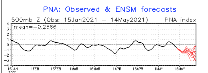
Yeah...it seems the models are trying to get us into a more important early warm anomaly ...and maybe we're just seeing a reluctant sort of emergence in doing so ? I've bee warning Kevin all morning about our sore-butt spring climate but it seems every time I do, the models deliberately go even more against - fascinating really... The telecon's are falling in correlative significance, (seasonally..) but ...fwiw the PNA is getting into historically deep territory in the CPC mean ... Don Sutherland had posted recently that it was some - 2.47 I believe ... At the time, this image below was not depicting what this image below is showing now - lol... The mean of those mop-ended members ... ~ -2 there, with a few members even deeper as we can see clearly ... It may just overwhelm the hemisphere regardless of any lingering blocking signals/tendencies.. It seems the models have been tussling between that happening and some backward -NAO exertion/driving troughing through the Maritimes but ...if this signal below gets more momentous it probably doesn't matter ...the progressive wave signature will transmit through the domain and send the western limb of the NAO domain space packing -
-
Outside my front door, ...which is gaping to gulp in the 76 F balm as much as a possible..., there is a metallic awning. These small dark CU actually ping the top of that awing as the pass over with small rain drops - like 10 drops per cu and that's it. Weird... Fair weather CU spritz. But, looking around, there are also glaciated nebulae encasing some of these CU edges so ...it's kind of hybrid between both worlds. Like it's snowing at 6,000 feet easily ... and very unstable but only in like 100 mb of total depth ... not much getting to the 500 mb level even.. Just bouncing densely around in that layer under a cap ... It's like a snow shower atmosphere sitting overtop a 75 F lower elevations..
-
Yup ...this GFS run continues to trend away from climatology on that ridge - and by that I mean, literally ...it is UNclimatologically sound to expect that circulation structure to win out that way - but ... be that as it must, if the present solution works out, we somehow dodge the N/door and/or BD boundary(s) through that period and spill OV/ G. Lakes early heat dome into the region. Assuming so ... this doesn't have any tracing back to a Sonoran or SW air layer ejection modeling so... the heat is sort of 'home grown' .. deeper tropospheric heights working with high hot sun of late spring will amass 82-88 time temperature departures inside that synoptic region. But keep in mind that we are still talking about D5 ... 7 with active polar jet streaking by N of Maine so it's precarious. I hope not ...I hate BDs with the passion more intense than the foresaid sun, but.. gotta be a realist too
-
Let us know how you feel over the course of the next day or 2 ? I'm getting my 2nd dose ... two weeks - I'm hearing wildly varying reports on side-effects ranging from nothing to an ER stint - no rhyme or reason or pattern discernible either. It's been yes and no for maybe cases in every direction. Zero pattern. I guess scatter plot or not...the average is at least a semblance of reaction above zero - so... I'm just trying to get a fix on expectation - ha, not that your experience should tip the registry here... I didn't get any notice/report from the first dose, personally -
-
isn't that 'Cousin Eddy' 's from 1989 Xmas Vacation - lol


