Typhoon Tip
-
Posts
44,565 -
Joined
-
Last visited
Content Type
Profiles
Blogs
Forums
American Weather
Media Demo
Store
Gallery
Everything posted by Typhoon Tip
-
I don’t think those are eye features they look like hot towers
-
August Disco 2021. Do record dews continue?
Typhoon Tip replied to Damage In Tolland's topic in New England
Probably limited band width to pay attention to this kind of thing but there is a signal for a heat wave next week-maybe the seasons last -
Oh shit. Lol I was looking at Grace and I said that
-
A couple pages behind here but yeah… Henri looks nasty now
-
Lol ... like the electron double-slit paradox that behaves like the electron is trying to be evasive - maybe we should all collectively ignore the forecast right up through Worcester
-
oh I see - yeah... No in this case the shear is outflow from that convection and it is joining into the on-going circulation mode/anticyclonic rotation, and that "add in" may be belaying the environment from transitioning into a lowered shear, by prolonging the N-E impacting vectors.
-
that's been doing that all day ... That region immediately/adjacent and west of your circled annotation is probably dim sun over 15' seas.
-
This is an immensely complex course work to do so. Start with this ... with scientific thesaurus in tow where needed: https://www.gfdl.noaa.gov/bibliography/related_files/jlu0701.pdf The HC's northern boundary where it terminates into the westerlies is not fix boundary or 'curb' in free air either. It's really along where the gradient steepens, and the jets ( westerlies ) ablate past.. .It bulges, up then collapsing down ... over time, while the mean width appears to be growing since the hockey-stick era of CC really begin in the last 25 years... Anyway, the idea leveled a moment ago was speculative that now is one of those expanded bulge times... I mean how hard is that to guess, when the 582 is so far N and the 588 too... We are immersed in 575 thickness, with 85/75 Peruvian jungle air. It's not a huge leap to figure why a TC moving into this region would actually NOT encounter "colder" conditions than it is leaving - at least not cold enough to be a baroclinic/frontal genesis.
-
Not sure I know what you mean here ?
-
Another ob that may be real here... I think part of the shear that is still sort of lingering longer than thought during the day ...might be caused by that deep convection that's smearing east off the M/A today.. .Fred's guts subtended just enough cool frontal slope in that region, and that's a detail the models probably were not resolving prior runs/days leading. So, we have -70 cloud tops exploding in linear clusters and that has an an outflow in it's own right -
-
know why ? ( wait for it - you'll love this one ...) Hadley Cell. I think so. It's shell is beyond our latitude with Henri fully still engulfed inside the non-hydrostatic boundary, it is behaving like a warm atmsophere/cold ocean relic and just starving as opposed to encountering thermodynamic gradients where-by commencing baroclinic physical conversion. Fascinating.
-
Yeah ..it's been the idiosyncrasy about this thing in model designs all along - refuses to obey planetary physics LOL. No but agreed - quite odd actually.
-
It's pretty clear ... whomever's near the "6.66" is doomed to hell -
-
I actually agree with "Snowgoosenaughty69" because the UKMET has a curved bias it has always had imho, dating back to the late 1990s. I still see semblances of it there, lurking in that model's ongoing cinema... So seeing it be the most dramatic in that regard - heh... okay -
-
Staring at that vis loop ... It's almost like it wants to molt - completely remove/shed the mlv vortex, and after it decouples, the pupa llvs coughs until it explodes new convection and goes on from there.
-
Ha haha .. this may be the most destructive hurricane to ever impact the NE alright - a hurricane name "Cried Wolf" will destroy any uncertainty regarding weather forecast competency, affectingly removal of any doubt -
-
The lower level would need to be feeling the steering ... It's not a bad approach to figuring it out but it looks like there's still shear in the mid levels from the NNE. I'm beginning to wonder... we may not see a shear abate from that source as much as perhaps anticipated, but similar to what you allude to ...wait until the llv and mid level convection begin to move along with the SSW flow over the eastern arc of the U/A low closing off, that is window of lowering relative shear. pure speculation.. But as far as what is plainly evidence at this hour, the shear is still hosing this...
-
Word! This thing looks like shit to me at this hour frankly. I keep seeing a flurry of post about explosions and detonations and go look and heh wtf are we looking at. Nick's post with vis loop - it's hard to argue that the inner sanctum of rotation isn't about to pop right out of the convective foreskin on that NW side. Things can change in a hurry and I am not 86 any forecasts here at all - just the now-cast gripes.
-
Yeah... time to update/re-install some concern spectrum: ... tornado threat with this spread out over all of SNE and probably the southern half of CNE ... There is a flood concern that is rather obvious shore to rain inland, which depending on where this land falls may be west at first... But if it does slow and meander E through southern VT/NH... that can be 24 hours training water boarding and massive problems if that happens. It's figuratively as though the dramatic "20 minutes" of land falling is 20 % of the crisis -
-
These land falling systems don't spin up - or tend to ... - the bigger violent types. They tend to be smaller 0 to 2 leveled whisking by. Which 2 can be deadly ...hell, 1 can be deadly. So can be a sunny day if the husband catches you with 'er - But systemically the trade off in violence is the 'swarming' numbers, in that there can be a lot of rad tripped warnings and dangling ropes
-
Was just about to post this exact couple of sentiments - ..and despite the air of exuberance in mood and posting spin, this is still all based on what ifs - granted, more plausible than 'what isn'ts' but ... storm enthusiasts that want to see their neighbor's property denuded from the face of the planet while leaving theirs ...unscathed with power still entitled and in tact, will need to get some realization of intensity/organization profile cooking here.
-
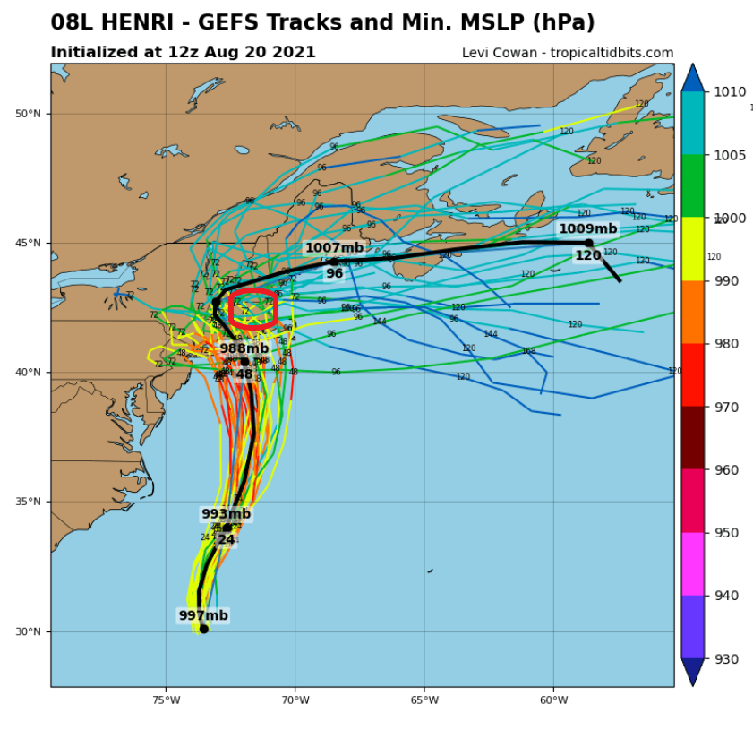
This red annotated region in that track wedge may as well mail in the insurance forms now ...cuz that's liable to be one contiguous tornado vortex if this ens mean works out...

-
It's definitely tactless and insensitive - I'll give it that ...
-
it's here : https://www.weather.gov/box/1938hurricane
-
That might actually bring surge waters into downtown Providence in that scenario. I think who's a 1938 aficionado ...I'm almost certain there's a high-water mark around Town Hall that has the 1938 ... I may be fantasizing that ... but, that Buzzard Bay in a bad bad spot for that stream line analysis - heh. Actually edit: that's kind of a weaker system there... well, maybe not. But if a stronger system moving into that position would be -