

Typhoon Tip
-
Posts
44,217 -
Joined
-
Last visited
Content Type
Profiles
Blogs
Forums
American Weather
Media Demo
Store
Gallery
Everything posted by Typhoon Tip
-
Yeah, agreed on the Valentine (~) Day ... I cited that in the beginning of this thread; we've all been sort of eying that range. blah blah. It's showing up (hint) in the telecon spread. And seeing the 00z EPS with the +PNA pulsation on D9 ...probably sets the Euro operational up with a memo to go nuts on D9 and there we go... Notwithstanding that, it may in fact be a more prominent signal than this little guy in the foreground. But the necessity in the here and now is more because, whether it parlays favorably or not the risk is still real - it's something fun to watch in the meantime. 'Sides, official offices are nodding to it. It's not being pulled out of nothing. I admit ..it's not the prettiest of signals... But it's better than no signal.
-
Fwiw - Extended Forecast Discussion NWS Weather Prediction Center College Park MD 148 AM EST Sat Feb 5 2022 Valid 12Z Tue Feb 8 2022 - 12Z Sat Feb 12 2022 ...Weather Highlights/Threats... A developing low pressure system off the Mid-Atlantic coast early in the week is likely to be close enough to produce a cold rain across eastern portions of New England and perhaps some snow for inland locations, depending on the eventual track of the surface low, so this event will continued to be monitored for future trends. Elsewhere across the nation, mainly dry conditions are expected for most areas, with the exception of some patchy areas of light snow over the Great Lakes region in association with the clipper systems, and some showers near the east coast of Florida with post-frontal onshore flow.
-
Heh... I think all private rec forms are legal use now? In Mass anywho. I was told by an off-duty officer that the same rules apply to DUI law, however... Maybe that will get finer tuned/codified, but it "seems" when the vote flipped the script, the systemic couching in was a first sorta 'guess' management tool. Anyway, I guess that makes sense? I don't know - I can't use Marry Jane. I tried it in my youth... Let's just leave it at some unsettling reaction. I'm not thrilled to use it because of that trauma. I am, however, thrilled that it is legal now - how many countless lives were ruined by what amounts (in my mind) to be puritanical heritage - Americana does have perhaps too many roots in early colonialism. Obviously, there's a whole sociological babble that is not appropriate to this thread ( hahaha), but that just being illegal was always suspect to me. I can't use it, personally. But I've never been around a marijuana fueled rage, or addict... and it has far to many benefits if used in moderation like anything else.
-
I don't remember that one ? ...I guess I can NCEP library that - is it an analog ?
-
Honestly ...I don't expect that to happen. Ha! If it turns into a "nice snowstorm," that would be a bit like accidentally inventing nitroglycerine. I mean there may be some subjectivity ... duh, in how we define adjectives like "nice," when using them to describe snow. And then stapling other adjectives like "storm" on the end of it... I really meant 'minor' and/or 'middling' - can someone PLEASE demonstrate this is getting across ? Anyway, I'm not sure these reconcile the former? I have to be fair, if ORH - CON-BGR axis pasted for > 6" ... that's not what I had in mind. I thought that might be more the ceiling for Taunton to Logan with metro west skimmed, up through PSM-PWM ... But, if it wants to evolve to more... I would say people should also pay attention to details when < 108 hours out, and the 00z EPS' 24 -hour d(hgts) through 90W digs some 6 dm straight up and down the trough. That's amount of amplitude increase is not as paramount as the move its self - maybe.. toggle between these if on a PC/Mac...not sure what you can do on your phones: https://www.pivotalweather.com/model.php?rh=2022020400&fh=96&dpdt=&mc=&r=nh&p=500h_anom&m=eps vs https://www.pivotalweather.com/model.php?rh=2022020400&fh=96&dpdt=&mc=&r=nh&p=500h_anom&m=eps
-
Sneak ?! ....this is starting to piss me off man lol, not you - hahaha... just in general. damn it - I mean, this may not happen... but people can't seem to read this without interpreting through an asshole filter. Everything I've said about this 'event' is f'ing clad true so for. I am not making this shit up. I do not have ambition - I am merely a fascinating miss-placed middle aged Met with no other outlet to vent my aspirations in this field, and you know what... ? People can bite me. And by the way... I AM WRONG ALL THE TIME. Rant over -
-
It hasn't been very convincing, no ... LOL - maybe replace 'convincing' with 'representative' as in ... at all. Firstly, minor to middling event, primarily for E and SE regions. That's not really changed. Admittedly, it would help if this thing would congeal a bit more. The 00z GGEM seems to like the event, as did the Euro, but the latter really is on the minoring side. You know, honestly, when I wrote that I wasn't even thinking in Ayer, MA ( situated NNE of Worcester by 25 mi). Either way, I was careful to point out the former bold content/aspects... Three points: - Some 'dependency' for this in that the field actually is okay for more amplitude. Often enough, when that canvas is observed, it is proven worthwhile to pay attention. Events will emerge given time. - If an event can condense out of the ether ..heh, it would be doing so in a marginal atmosphere, prior to March 1. That's not a slam dunk for rain, particularly when hydrostatic heights are at or < 540 dm range. The 06z NAM version shows how intensifying QPF through that thermal plumb immediately flips the ptype. I think the problem on guidance to this point, is that it's been too light - ... it may in fact go down that way. The top line in the thread also said, "Low confidence" - It was also made clear that some purpose for this thread's creation is because there's not much else going on ... The other option is 10 days of doldrums. I almost wonder if folks were not clear that the latter is the case, because there's seems to be an entitlement attitude to a steady diet of inspiring snow drama. Haha... in other words, the general reader needs to get with reality that this is a dearth period without this, and consider it a blessing really.
-
“…I'd stress minor to middling affects from this for now” The alternative is a lot of days of nothin - I think folks are attempting to reconcile expectation against present middling signal, which there is gap there. I mean it may improve … let that marinate from a position of more modest expectation and the purpose of this might work better for you.
-
Will brought it up …
-
By the way ... I started a thread for the first of the two possible events spanning the next 10 days. That being ~ Feb 8. It's modeled as a low return on investment right now, but it has a higher upside should stronger relaying S/W mechanics get involved. We don't have a have a lot of time.. maybe a one day's worth of cycles....eek. The one at mid month is also in there, but I don't like the models trying to re-introduce more gradient across the continent than we really need. That's likely to interfere negatively on phasing ...and wtf am I talking about at D9 ...but still -
-
That's yeah right where I'm heading with that 'blues' so we'll see. Looks like a candidate from this range. You know I think that April ?23rd? 1987 storm was one that was marginal and over achieved. I start thinking back on some of those that were like this in the mid range, and then even as they were happening ..the NOWS started flipping to crazy parachutes. The first of the two back-to-backs in Dec 1996 did that. I remember the cat paw rain and wet snow forecast go to uniform large aggs with with 4-6" in the Merrimack Valley not really well forecast. It seems we don't get those kind of positive busts as often anymore - probably hard to sneak one by with a colonoscopy of model probing tech now used cut up coke lines LOL ...
-
Will's right.. we start playing 'fake warmth' perception games - that time of the year. Nape days as it were. In fact, when it goes calm-ish, and the sun is allowed through, the "fake warmth" can con you into thinking it's actually warm. And it kind of is .. I mean I've seen it 55 F, ooa February 15, under 538 dm thickness and 0C at 850 mb, ... with mangled snow pack still in the region, too. It's super adiabatic in the lowest 300 ft ... That's in the 60s in March. But it's not really warm, as the sun kisses the tree line and 1/2 hour later it's 28. Maple sapping season gets under way -
-
Mm... your right of course. But with hydrostatic heights in the 535 -540 range, this is a candidate for a blue bonnet special - the problem is, we are not getting to see the QPF depictions for those amped members - I mean are we? The operational skims by and drills to 987, but it tickling the column. We need this closer than that, so there's work to be done.
-
Jesus Ray ... okay everybody, pay attention there. That is how we gripe the right way LOL
-
Well,... the Euro came in okay for a SE/E clip. Seems to be a modest trend toward more there in that guidance. Plus with Will's EPS ... The GEFs faded though, after looking so encouraging on the 00z. I wanna emphasize, this is low confidence as was written. I think the alternative is endless, non-focused meaningless banter and stagnated winter boredom so what the hell - maybe not kill the thread just yet LOL
-
Echoing what Will was mentioning... We have steady small flakes now accompanying the sleet, falling enough to start lowering the visibility more.. Ayer 30F
-
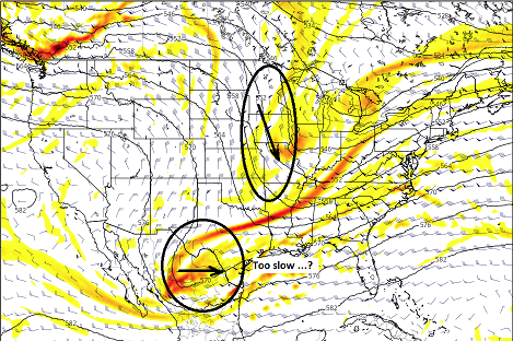
OH man ... where have we seen this before - ... Seems to be a recurrent theme here where the western ridge ..sort of bumped slightly west of idealized/climo ... , causes the flow to tend to split as it descends over the Rockies. That's okay, "if" the southern aspect can somewhat get booted E ( I've annotated that question..). But the models are dragging their feet wrt to that. This was an issue leading the blizzard wrt phase proficiency. It would appear similarly circumstantial - albeit a less magnitude version - with this D5. It's really quite similar. If the ridge in the west - I feel - were to amp it would help conduct these features into a better phasing...
-
Ah.. thanks!
-
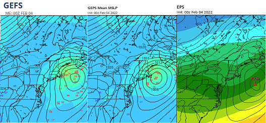
Low but growing confidence? I'll keep this comparatively brief ( yeah right LOL ) as there's been some awareness already. So overnight, the various techniques have begun what think will be an eventual better coalescing around a "pass-time potential." I say that in quotes because for the time being, this doesn't appear to offer much more than what that suggest. A reason to pass the time... heh. But it appears credible enough. I'll be happy to change titling and or commit this to the graveyard, which ever it eventually needs. I'd stress minor to middling affects from this for now. It is noted there are some individual members of the GEFs and GEPs that are situating 970's mb lows across the outer Cape waters. Those, however, appear to be exceptions to a mean that is too torpid by comparison to take them very seriously. It could evolve more... yup - but for now, here are the means (courtesy of Tropical Tidbits): A little deeper philosophy if interested... This period, D5 -12 has been interesting for me since the blizzard because there has been a cross-guidance ensemble tendency to 'relax' the 500 mb non-hydrostatic height medium across the hemisphere's mid latitudes. Typically when this happens and moving the static quo from a cold regime into a relaxed one, that can trigger synoptic events. Today's event is really the leading edge of a cold reload, but for several days we may end up with hydrostatic height gradients, amid a less destructively fast non-hydrostatic medium. As I've also mentioned ... there just been one problem. The operational versions haven't been too keen on delivering S/W mechanics through that domain. Like wasting it...ugh. This has been true among the members of the different ensembles, too. I've been checking, daily. Nada. Then, overnight, this above. I'm aware that the EPS looks like shit there, but that's a substantial improvement over the previous 24-hour fix from the 00z/03 Because the synoptic super structure like the less larger --> short wave interference ( which is inherent to slowing the field ...), then this materializes, that succession of circumstance sort of gives this some room for consideration in my mind. Hints gathering toward a notion and correction vectoring etc.. So, we'll see where it goes. It is D5, and ... operational runs - in theory.. - would become more useful to this soon. The GGEM is the most emphatic of thus far - I know ...I know. But I was looking at the individual GEF members and it is interesting that 2/3rd fo them are more robust than the operational version. Just wild first guess: the marginal aspect of the thermodynamics appear just cool enough to me, that if this gets more robust ... more directly impacts the area, it would likely become a lower ratio snow. Yes I'm aware there a vague signal perhaps materializing toward mid month separate matter.
-
Nasty out there ... 32 90% PL 10% ZR here in Ayer Delayed transition over colder guidance's timing it would seem - not hugely..though a little. Really just flipped over the last hour. Street whitening with pellets pretty quickly ..car top, hand rails..etc..
-
Cc is real end discussion
-
Yeah… I think what the model’s attempting to do is flood the Hudson Valley cold south and then the onset of tuck jet invades Southeast New Hampshire blowing over E Mass/RI. Its situating a quasi-warmer seclusion between the two over Connecticut
-
I think once we see pressures begin to rise east of the white mountains up there we may see that same affect back east cross southern New Hampshire and northeast Massachusetts
-
Meh. The winters are getting disrupted, period. Making climate numbers off over producing minor systems that are benefitting from a theta-e bloated ambiance, meanwhile winters leaving huge potential consummately untapped … is a weirdly reduxing behavior and is different. And a random Feb or Mar that didn’t leave as much on the table …? Yay Those are exceptions to the rule and don’t abase the longer term. I can’t allow myself to hide behind climate numbers to avoid admitting an unwanted change - that elides the reality.
-
I knew you guys were going to jump all over that "impression" with numbers but the numbers lie. The relativity of it is that those winter left a lot on the field - that's more like what I'm remembering. The tough losses have been increased in frequency. I think it's partly because of the fast flow problem that is fact - when commercial airline industry has set most of their air-/land speed records since 2000, etc... Anyway , we are seeing above normal snow fall winters, mostly as a function of increased theta-e loading - no doubt related to climate model predictions to do so, in a warming world. But, the the ways and means in which we are increasing those is more a function of just whenever anything is falling from the sky. In fact, I'd be willing to bet some of the 60 years in his list were few events number years. It's inflating numbers to get big totals in few events, sort of belying the truth of the aggravation in between times. Interesting...


