

Typhoon Tip
-
Posts
44,217 -
Joined
-
Last visited
Content Type
Profiles
Blogs
Forums
American Weather
Media Demo
Store
Gallery
Everything posted by Typhoon Tip
-
Bump for bearing current relevancy - ... here we are again, in May, with clockwise circulation node emerging (modeling) between NS/Cape Cod. This delivers 'over-the-top' early heat signal ... targeting SE Canada/ perhaps NNE ... maybe as far S as NYC...etc, with anomalies that push those region above areas from TV-MA ( possibly).
-
GGEM brings it from DTX to BOS for how much/little it's worth - Hate to say, some kind of warm anomaly fits this: How far it actually goes or what orientation, who knows...
-
I thought it was supposed to rain tonight - whatdya mean
-
Wait ... so you're gonna install your AC, for heat 600 miles away up in Toronto ? Interesting... Sides, window units are phasing out. They're loud and power exhaustive and not terribly efficient - some are better than others..whatever. Homes and other edifices are getting out fitted with what are called, 'mini-splits,' which do more complete environmental controls vastly more efficiently, within the air space itself.
-
Slowly ...yup. But it could yet come back...? I don't put it beyond the GFS to try, but frankly I think it will win in this case. I think there will be a weakness there, but yeah, the GFS was likely over-blown ( pun intended) Other concepts: There is a hugely consistent, multi-domain space mode change signaled, all of them actually... The PNA flips negative. The AO flips positive. And the NAO flips positive, all dong so along the same temporality. The PNA, or NAO alone backs away from a GFS support, but doing so in tandem connotes a GFS' deeper solution even less. I feel confident that the GFS' speed bias is playing into that ... A weakness - I think - will be there. Because here's the confusing part: the hemisphere is fast, anyway. As an aside, I have noticed - as have others - that there's been a tendency in recent May and Junes to through heat anomalies through southern Canada, while setting up a SE inflow - almost like a displaced Trade wind anomaly - into the M/A ... I've referred to this as a "continental Kelvin -Hemholts" effect. The fast jet lifts N, then there is a kind of counter-balancing ( non-linear or "emergent") tendency for the flow to drop S over the Maritime ... well basically, imagine a Bermuda clockwise circulation displaced N of normal. This has been observed; the causality is all theoretic conjecture... Either way, I don't find it coincidental that here we are, another May, and these models are putting +16C at 850 plumes over the tick country of southern Ontario, while it's barely 10 C near DCA with a some sort of weakness there.
-
I've been referring to it as the month of Anus ... but no one's taking to it so I'll desist eventually. This is a particularly un-redeeming time of year. Loathsome month. Some rare ( what? 1:20 return rate) we'll get quality but dry or not, this was a climate shit-hole April like any other. I really don't care that much about direct sun. Temperatures piss me off. Yeah...that's interesting. I wonder if all this can find agreement among the various climo sites.
-
It's funny you bring this up ... I mentioned the GFS tending to accumulate too much gradient out in time, as a kind of static bias of that tool. I haven't delved into any hypothesis as to why - tho I have them. I've only mentioned occasionally that it does this. It may in fact be the thermodynamic (evap/condensation) handling in the ongoing total atmosphere. I remember about 4 years ago... maybe 5 (2017 or 2018) ...there was a powerful March storm taking shape in the models, parked perfectly E of Long Island. I don't recall what the other models were doing ...but the GFS at the time kept hitting at 39/31 type T/TD spreads 3 .. 5 days in advance. Within heavy comma-head QPF, no less? And with a CCB coming in under 850 mb temperatures all of -1 to -2 C, there was hope for uh ...other. This was also a recently updated/new version release of the GFS. We are all speculative of course ... It was as though the model couldn't wet-bulb. It got within 80 % of doing so and halted the gap. So of course ( lol) privately we were all hoping 33 or 34 wet bulb blue bomb snow disaster could be in the making.. haha. Ennnnnt! ( enter buzzer sound)... What happened? 33 to 34 F saturated cat paws and straight rain to 2.5 or 3" of hydro. Oh, we were right to question the new version of the era's GFS, but it didn't pay dividends to late season hopefuls..no. Wah wah wah. there was a pesky 925 mb +2 or something... Still a bizarre event either way because that was slam dunk for dynamic isothermia that evaded taking place. The storm actually maxed out at mid levels prior to arrival...I wonder if that idiosyncratic timing has something to do with it... Anyway, soon after a new version of the GFS was suppose to have addressed that stuff... But I wonder if there are still some 2ndary or tertiary type d3' aspects that nag at it, perhaps ultimately rooted back to when it was more glaring - like in that March storm's case. Thermodynamic 'bugs' in code
-
Yeah I just dropped a post in myself discussing my personal hypothesis on "GFS creating its own error space" ... either way, comes to the same recourse... EPS/GEFs blend.
-
mm .. nyeah down by Hatteras? It may be more problematic down that way, but how much so... too early unfortunately. The thing is, these west Atlantic "true" cut-offs have a climatology at this time of year. More so in April ... but it is only early May. (2005, May, was not the same thing for those savvy). That all said, they can be over assessed at this range. I'm almost positive last year dealt with one of these in May modeling. We had to sit by run after run, slowing it filled and minored in the guidance... and then what verified was a heat wave for S. Ontario and Quebec, while a mere weakness set up east of the M/A...and SE surface wind kept that region tucked with 70s. I could see this doing something similar with over-the-top early warmth being tucked under at large synoptic scales, and that the GFS is dumping a surplus of mechanics into what may in fact not really exist - again...an artifact of it's bias.
-
Yeah, I was noticing that... Thursday looks similar to yesterday - though not an exact match. ... Wind drops light, with mild -ish 850 mb temps, and a flow between the surface and that level averaging d-slope. 700, 500 and 300 mb RH mean values < 50% suggests ample sun ( using the Euro for these metrics) would suggest more on the clear side. May sun doing the rest... Euro 2-m is 69 at HFD and 64 F at BOS... But those appear to be the adiabatic temps - they don't calculate the 100 meter near the surface, where it's sloped sounding under a broiling sol. Add 4 or 5 to HFD, and BOS gets screwed within 5 or 10 clicks of the Harbor by the usual. GFS synoptics are not enough different.
-
The GFS creates it's own error in this case. It's consummate over -evaluation of westerly jet power. As an ongoing problem ( a see in this guidance), it cumulatively end up in late mid and extended range, with too much westerly wind velocities, and too much hon-hydrostatic gradient out in time. It's basically consummately after cooling the polar side of the jet. For example, by D7 ( most notable in DJF) compare the Euro with the GFS and the latter will be 3-5 dm colder in the cold cyclonic regions over the north side of the ambient polar jet. It carries, even in vague semblance, on with this tendency... Among other aspects, it fights seasonal change; at this time of year when that change intrinsically is trying to relax the hemisphere, it's trying to load gradients. I think in this case ... what it may be doing is that it sees the flow as relaxing, with the +(AO/NAO) but right at the boundary of that transition/mode change, it has a resulting surplus of wind mechanics and cold that it's stuck with ... it drops in and gets caught in the weakness. I think there will be a weakness there ... astride the MA ... But I suspect the GFS operational, being the outlier - and having it's biases - is too much with that.
-
I'm not to worried about it, seein' as you asked me and care what I think. no but the ensemble mean of all guidance, including its own GEFs, are no where near as prominent with that feature. Even the operational version of the Euro and GGEM are less amplified overall.
-
Gone mad or not... we are definitely behind recent year's behavior with our timing in particularly above ground deciduous species. Bushes and shrubs are leafed out, but even those appears stuck at 80% or so - they don't seem "full" The tree I lovingly refer to as 'General Sherman,' that looms over from its kitty-corner anchor at the nexus of three properties, including mine, is skeletal. Sucker stands some 70 or so foot maybe more, with a canopy span that's perhaps 2/3rds or more of that same distance. It's an old, old Sugar Maple... I'm guessing by the 4' ~ drunk diameter, probably got it's start around the Industrial Revolution. Anyway, Sherman's never gone this deep into spring without at minimum, notable swelled buds. As of yesterday, it had not. I haven't actually checked this morning... We pinged 73 yesterday and having stayed above the 30s overnight, who knows. Even the Silver Maple across the way, which tends to drop its reddish bud detritus by early April most years is being ambivalent about unfurling leaflets. That sucker usually has the beginnings of dappling shade over the road it claims by now... The only exception appears to be the Norwalks; they are flowered out now everywhere. I don't know how or why... "what" may be more apropos, decides when all that gets underway. It can't be the temperatures in April alone. That month was modestly above average. Maybe it's the behavior of the temperature some how. Could it be that plants are like humans, in that they get pissed off by shit-showing asshole cold windy days. That would be neat. I dunno.. but if I was tree stuck out there in this last month's piece of shitness I think I'd-a checked out too. Lol. Regarding that... I have a question... We have the running and then final average temperatures for the month of April. But those are doing the diurnal totals. I was wondering if the lows, or highs are averaged separately? Maybe the highs were below normal, and the lows were above normal ... but just by enough in the latter that it pulled the totals above.
-
Hey PF ... beware over-top May heat
-
Well that 66 at FIT and 64(?) at BED busted warm like we thought. Both bootlegged a 72 off 71.6 according to MESOWest... either way, good call there - Also, as Scott suspected, BOS had no chance of making 66 in a zip gradient full sun May day while there's super adiabatic overturning inland.
-
yeah... and the rain we had recently - all told I don't think it's ( fairly ) been that bad. I'll admit, as bad as the March 20 - May 20 time of year is both notorious, and earned for climate, we haven't head any of those week to 10-day long protracted wheel of wet deals that can often also be a part of the prison term. This years rendition of shit time of year has been more related to unrelenting poorly timed, cold, with what wind there has been, during day light hours related - it was taking the sun on mono e mono. But it has been particularly acute, despite data - sorry... the data and the daily weather experience do not always reflect one another. Said climo sites are barely plus for April ... T and P. Thing is, the summer's liable to be hot. That's my personal leaning idea for now... Responsibly? A couple of good 2-3" basin-wide griping, pissy post doom and gloom mood events before that heat arrives would be better for the region. Not likely get it... no.
-
I'm not 'as' pessimistic about this week. I'm between Scott, vs Kevin's spin tactic ( his intent and reason for doing so a complete mystery -).... but closer to Scott's side. I think we get into a light passage of showery rains tomorrow night and mid week, but I don't see the days troubled by those blue hydrostatic crayon lines. In fact, as an aside ... two days of runs consistently showing 0 snow blob ptypes on QPF charts anywhere in New England, is a stunning achievement either by the GFS, or just this 2022's particular spring's learning curve. Anyway, I'm not sure what the sun quota will be in between these maintenance rains, but with 850s above 0 now through all periods, it wouldn't take long to pop 10 F on top of a static morass - I mean just having that built in is a huge milestone - and notice? The month of Anus has to officially close before the models paint a portrait like that? I'm kidding but I'm glad it's over. The extended still looks like a pretty coherent paradigm shift takes place across the hemisphere. Moving toward -PNA, +(AO/NAO) in tandem is a huge total scaffold change from erstwhile Neutral/positve PNA with -(AO/NAO) Pretty much a diametric indicator. This was hinted off and on over the last week... Often times, major shifts do that before the telecon's bomb the current mode out there in time. The operational runs fight it too... The GGEM is the only one that really shows what that total manifold is capable of ...with 588 dm non -hydrostatic bubble inflating to almost DTX out there at the end of it's run. That model is still a Dr Jeckle and Hyde product and can't be trusted, but it is better than it used to be. Given that it fits the telecon of the GEF/cross-guidance suggestion, and the oper Euro and GFS have at least some semblance - though clearly they are doing everything electronically possible to damp it out for whatever reason... ( the anti- DIT factor? )... Anyway, model solutions "like" the GGEM's D8-10 movement might emerge going forward. Could be a warm mid month... And I'd also forward that 'over top' heat waves have been getting more common in recent decade springs. interesting...
-
Yeah ... this date could take first place in the diurnal recovery competition, no doubt. 33 to 36 at all home sites within a couple clicks of mi casa here in Ayer, where are all not 58, averaged. I man 20 to 24 recoveries by 9:15 am is like almost desert replace rates. Gettin a nerd chubby
-
Can you move those high temp aspects Scott and I just had over in the Anus thread to this one? I didn't realize we had a May thread going -
-
also, Scott and my conversation should be moved to the May thread - didn't know there was one ..
-
Actually ... at both sides. I think Fit to Bed are underdone. 900 mb's all the way to 11 C by 4pm ... straight adiabat would support those temps, but we have dual factoring of d-slope trajectory ( albeit light) under about as utterly clean unfiltered solar as can be physically possible in Earth space. SO, the 2-meter seems it should make 72.. It's a silly minor tedium and not meant to criticize NWS or nothin' I'm just curious how it ends up. But BOS seems it should flip on shore with the light wind field, no doubt...off Harbor SST makes 66 seem a bit lofty out there on the ice float heh
-
It'll be an interesting minor test today wrt these NWS forecast high temps..
-
Imho ..the biggest defining factor and difference today isn't the 5 extra degrees ... which don't me wrong, very grateful! But sans the wind makes for a HUGE improvement.
-
This may be the diurnal winner of the year. wow. 28 here just prior to dawn, now 59.
-
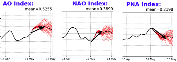
mm. The AO flips dramatically positive in the GEF/American telecon - decent agreement among members considering the time of year, too. The NAO neutralizes over the next week, then... the mean creeps positive into the 2nd week of May. The PNA has corrected down, now sloping negative for a total -D(index) of 2 standard deviations in 10 day? Despite where we've been and/or how ever impossible it is to imagine that being the case in this Stockholm prison camp known as the month of Anus in New England, that's a heat signal out there. Yup - But by heat signal I don't mean "heat wave" per se. It means a paradigm shift away from achieving above normal temps in a cold pattern ( ) bullshit, toward one where every metric is above normal - measure and feel. We'll have to see how persistent this signal is.. It's a mode change - but all fields involved signaling, it's a hemispheric guard change. Nods given due to the weight of having all these fields flagging warmth ... I'd say post to the 7th at minimum but more like approaching May 10 - could be faster with radiative forcing ...
