

Typhoon Tip
-
Posts
42,349 -
Joined
-
Last visited
Content Type
Profiles
Blogs
Forums
American Weather
Media Demo
Store
Gallery
Everything posted by Typhoon Tip
-
Man.. d-drip solution Chakra channeled straight from Shangri-la solution D8-10 on the GFS That's no HECS ... it's a BECS Bible bomb -
-
Other way around... the move switch from negative to positive was the focus of the study.
-
That's a monster at mid levels ... D10 .. vague support at best, however, so best advice is to set one's expectations accordingly - which given those indicators ..expect that NOT to happen. good eye candy.
-
I think this run, right now this morning ...is sort of pivotal in 1995 for assessing what happens Tuesday of this next week. Not so sure about 2022, tho. ( has that for spaghetti logic) Back whence, ...even through 2010-ish, we could almost count on wave mechanical relays from off the Pacific as having been 'under' assessed, and then they get physically sampled and included in the initialization and ... boom! Pays dividends to the winter enthusiasts over eastern mid latitudes. If not, one might at least observe better model continuity begin moving forward, also getting cross-guidance contention less distracting, too. Sometimes when doing so, what came out was a "Boxing Day Storm," short duration pretty babe pay-off. I have not seen pay-offs since then, like that. In fact, I've seen the opposite happen more often. Different discussion... But the S/W presently nosing over western Canada has been erstwhile over the Pacific for days. It's about to perform an interesting aspect in all the guidance I've scanned. It bifurcates passing over the Canadian lower cordillera, probably because the +PNA ridge is more likely to be considered a "west biased ridge," which stresses/ .. pulls the wave space apart went it starts descending latitude over that region. Anyway, some 1/3 ( or so..) of the wave energy shears off and tucks briefly over the SW... the remaining ballast moves progressively across southern Canada. It's after that that things get complex.. The energy in the SW gets kicked E as the +PNA ridge tries to reassert back into the west early next week. The N/stream then fails to show up at the party. It's too bad too...because the southern stream impulse is plenty to be a phase seeder space, but that N/stream just doesn't contain any meaningful new S/W to drill and have sex. It's okay though... if that southern ejected energy is better looking, it can put on a good show all alone.
-
Mm ... matter of subjective analysis, but I wonder if that "what if" would be so... If the -NAO was not a part of the larger synoptic circulatory manifold, I suspect autumn of 2006 ... 1999, with a flat ridge sans any meaningful CAA events through that month as likelier. Particularly 2006, stringing days near 60 ... even briefly 70 F. That also happened back in 1999 I believe it was...though it may not have lasted the whole month. I recall a six day stretch in the high 60s, two days of which were in the 70s that December. Both then, 2006 were dominating -PNA with virtually 0 polar mass field modulation S of the 50th parallel. I suspect "would have been" 2021. But that's my take - Having said all that... I agree this year's NAO was too aggressive, either way. What "if" we modulated that -NAO less strong? I have a personal hypothesis: we needed to modulate the -PNA less dominating, because that's the source-origin. The -NAO's character was driven by the former. It's complex, but, the super-synoptic forcing came from non-linear wave mechanics. Think 'rogue wave' phenomenon in the oceans. You have A, B, C, D ... H waves rolling/interacting, constructively and destructively interfering. That type of interaction means waves B and C may physically dump energy into H, while the wave spaces in between do not apparently observe effects. This is as opposed to linear wave interaction, where A directly influence B ... directly influences C ... F and so on. The flow was fast ( what's new since 2002 ~), and the mean polar jet suppressed along the west coast/Rockies, and instead of big direct, linear response of a ridge over the OV, there was a flat ridge, with even a modest trough in the west Atlantic. But all that stored momentum then buckled the flow hugely over ( in particular...) the western limb of the NAO domain region - that's H in this example. It gives the allusion of the NAO obtruding exertion, but it is ultimately caused by the same RNA.
-
Let us know when it starts …
-
Yeah... I'd caution folks not do that heh. I realize there's some snark comedy going on with it right now - not sayin' it ain't exactly earned, either. But we all blow it sometimes, and once the local hemisphere exits this 72 - 96 hour window, that needs to "reset" expectations. The look out there in the latter/deeper mid range is different in total so it's apples and oranges at either end of that span of time. Let's also be fair, the Euro corrected by 84 hours. A bit shallow for some tastes, and frankly, a bit out of character considering it's longer term verification profile, too. But, that's not nearly as bad as though it still carries it say ... spooking offices into headlining. The solutions dumped 3 days in advance. I think - not necessarily you per se but the general engagement in here ... - there is this tendency to impugn a guidance if they don't persist with dramatic solutions. It's getting into that aspect where where it seems the resentment is really about modeling experience ahead of time, and not having that be tainted, than it is the actual storm.
-
Yeah agreed... wrote a bit about that a couple pgs back .. interesting stream interaction could evolve there.
-
Ah ..well, it'll be an interesting battle perhaps. My personal suspicion is that the warm event frequency increase is connected to the Planetary concerns ( to put it "mildly" hahaha)... The SSW needs to fire off sooner rather than later or I will be a very dull boy ... spring enthusiasts don't need that happening in mid February... or you can check out until June 10 with packinmg pellet virga flurry days in May
-
You ENSO folks could also take a little pride away from a mild end/early spring. 'Less I'm mistaken, that tends to be the case with La Ninas. I do think the gradient rich hemisphere and faster flow that causes ... skews some of these longer term type telecons, but ... here's then thing, and there's no real away around this being that it's rooted in fact: The last 6 six years of Feb and Mar's have too often hosted big, and I mean approaching ludicrous warm week(s) event(s)... three of which were even 80+ prior to the Equixox, and barely out of the solar nadir of Mid or late February. They just slip below the care-radar, because some of those years also featured decent winter storms after then fact as blue bombies..etc. But those warm ups have happened regardless of ENSO states ... and they were alarming. When we are enjoying 79.4 F at 4:30 pm driving home from work on February 20th, we don't think of that as a "bad" but it's like +34 ... Sorry babbling .. .my point is, those don't appear to be driven by ENSO ... but rather, just seem to be happening with greater frequency. Won't go into why - that elephant is what it is... But, since La Nina favors early mild runs anyway, I wonder what happens if/when the former background is occurring during an El Nina year that is actually attempting to look La Nina for a change... Just a wonder.
-
Do you know the title ?
-
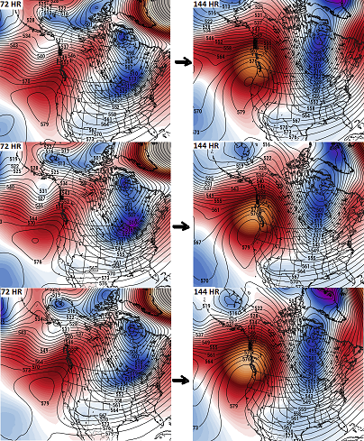
Low probability, but there is a non-zero chance for 'positive return' scenario early/mid next week ... monitoring interesting stream interaction 120 to 156 hours ( from ~ 06z start point for the purpose of this missive, but others may also have noticed this going back a couple few cycles) . Am aware we've been discussing the 22nd and 24th. This is relatable to the same 'synoptic superstructure' of concerns, but is a shift of interest to very late on the 24th through the 26th. Longer concept rendition: Part of the problem with the 22nd and the 24th they were too vague as focus times in a generally. They were chosen because there were at least 'soft' impressions nested in a general favorable flex in the +PNAP. I annotated how/why ...now scrolled between too many pages to bother dredging it back up, but note the 00z to 96z delta(hgt) overlapping the WC and B.C. of Canada, https://www.pivotalweather.com/model.php?m=gefs&p=500h_anom&rh=2022011900&fh=0&r=nh&dpdt=&mc= --> https://www.pivotalweather.com/model.php?m=gefs&p=500h_anom&rh=2022011900&fh=96&r=nh&dpdt=&mc= - also the case in the GEFS and GEPS, en masse consistently for days. Typically downstream of that kind of modulation, ( and the weight of the ens means/cross g support notwithstanding!) interesting goodies will evolve. It supplies a "correction vector" to the field pointed toward deeper trough materialization as to where the models are likely to correct toward - hence the terminology. Look for more amplitude to emerge in future guidance ... with no guarantees that will actually happen. Heh, we used to say, "It's not that my forecast was wrong; it's because the atmosphere didn't cooperate" LOL That was true for the 22nd and 24th .. I feel the simultaneous correction of the models to speed the flow, a leitmotif (recurring theme) where they correct the flow faster moving ext to mid range, intervened on intents and purposes so to sepak - ..don't wanna get into it, but they all do this and have been for years now. It I suspect it partially reared its ugly disruption, where the models have to deconstruct their own wave mechanics in time, introducing more and more negative interference as an increasing offset moving D9's to D5s. It could very well be why this phenomenon of huge systems tending to pedestrian as they get nearer..etc. It doesn't mean things can't be modeled and holed to happen. It doesn't always happen where the models do that. Also, if a given S/W are more amplified, they offset and still torque the flow more. Trade slow moving, very deep results, for shallower ( still potent) faster moving results. This idea below could be that as these two may significantly ( positively ) offset. This is the 06z oper. GFS, as it sets up a 132 hr vision.
-
There’s a clipper that keeps showing up … Tues. even in the models that don’t, there are gaps there and ‘nature abhors a vacuum’ in either principle or practice - that’s code for those perhaps filling one if that’s isn’t already happening There’s only so much room for that to amplify due to flow compression … but it could be good for an instability bursty 2-3 ..4” It’s also settling into that pattern look we’ve been eying that appears otherwise destined to fail … I didn’t personally feel comfortable about threading for either the 22nd or 24th because of the way spacing and tensions in the destructive interference it’s everywhere in the flow… Hoping that would iron its way out but it didn’t and apparently it’s just gonna go down that way. I think part of the problem is that “good pattern“ was also one hosting flow compression, yet again … caught up with a models. And that’s been an ongoing problem where the models tend to slow the flow down too far in the extended and then have to speed it right back up again; that’s introducing a +Delta( negative interference) overtime Anyway …watching a clipper …for now but low confidence overall
-
Lol... like, everything that's happened so far has been weird. Why shouldn't weirdness work for the better, just the same -
-
No dig on DT but that's funny LOL... So dead panned.
-
I dunno, maybe.... I mean what would cause that to happen? I don't see any mechanism for that, and in fact ...the flow being of canvased progressive in character, lends to these features maintaining their procession space - the flow is not going to accordion like that. It's more likely to have one or the other just end up too weak ( or weak enough) such that it doesn't interfere with the other.
-
My sense there ... if this is going to be the focus, such that the 22nd "winds" vs the 24th ( like I said and maintain, not likely to get both done due to wave interference), it will get "less stressing to believability" by becoming a more and more dominant lead trough - it'd start to emerge that way going forward.. That whole positive sloped L/W that pinches off routine, seldom is handled well .. nor occurs very often. I mentioned earlier, usually when we are caught in limbo between to waves in the guidance, ... one or the other tends to become dominant and the other becomes nothin' They can also interfere and nothing that way. But cross the bridge -
-
Right - that's what I was suspecting .... trend -
-
What was the 00z ?
-
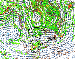
It is delicious looking ... There's a classic entrance region to the upper air jet over central New England, and the exit region of the 500 mb ( echoed by the 250 above), kissing its ass off the Mid Atlantic. Those two fluid mechanical aspects correlate well to strong surface low pressure genesis in that region, due to causing UVM over a broad area. Enter, that is a climatologic region there along/astride the MA, because that's where the polar continental air meets the ocean and all that.. Add in that at the surface, at that time, that zone is being enhanced, with a very cold air mass lingering over New England and the eastern OV ... tucking down into the regions of PHL or so... that means there is a strong llv frontal boundary extending NEward of the coast. That feature would set up a steeply elevating frontal interface - ah... it just makes the rising air do so more efficiently...which lowers the pressure beneath...etc. Lot of synoptic signals there within that frame going for it.. The problem is what is happening outside, and if that frame can even evolve to a state where those goodies can take place at all. This is actually day 5.5 really ... Not hugely absurd to be handled but still just outside the Euro's wheelhouse. I wen all the way back to hour 24 ... it appears this system's sensitivity isn't coming from the normal uncertainty Pacific. The contributing mechanics are all over western/NW Canada already, and also ejecting from the SW ... over time, there is modest phasing over the western MV, around 96 hours ... eventually it curls around and does it's thing along the EC. The bottom of that trough is attempting to pinch off from a positive aspect.. Basically, it all comes down to that immense engineering feat by the Euro that takes the next 4 days while over the continent. Doesn't lend to confidence.
-
So does every scenario where that's ever been modeled it seems. The temp spiked to 46 F along the underside of this occluded boundary... almost like a warm seclusion parcel over eastern Mass. I gotta admit, it was beautiful, as it was accompanied by sun splashing between the fractal nimbus. For a moment the nostalgia of a early spring flooded over me and I felt it too. I come in here, and there's sentiment of being done with this winter? Yeah... I got seasonal fatigue, probably because the last two events were overly exhaustive. It's nice to pick up on an event early, and then have modeling choices that offer different perspectives on how it may be fun. That's the hobby/engagement.. It is not nice to pick up on an event early, then have modeling choices that offer nothing but ass-clown oddities that really should not happen, actually then ... go ahead and happen. We've seen some backdoors ruin life - those probably own the ranks for short duration shock and awe. But these front-cyclone-side deals in the winter, where cold successfully replaces to this extreme, I think are pretty rare. I spend time anecdotally yesterday outlining at least one circumstantial oddity, which took place back in 1994. Blah blah 9 F at 8 am, light snow --> -ZR --> -R --> broken clouds, windy, 62 at 8 pm 1994! That's 28 years ago. That's what it took to f'up this winter that much more. It gets old. One can see why check-out might come early this year.
-
Yeah.. haha. .. just read the ext. forecast discussion and there headline sums it up nicely! Extended Forecast Discussion NWS Weather Prediction Center College Park MD 1149 PM EST Sun Jan 16 2022 Valid 12Z Thu Jan 20 2022 - 12Z Mon Jan 24 2022 ...Cooled Deep South to East Coast Snow/Ice threats with uncertain wave genesis pattern...
-
Looks on rad as though the low must be rollin' up the Hudson/SE NY ... now N of NYC.. looks like 4" inches here, ... but that's an estimate. I unfortunately didn't get a measurement before this flipped to rain at around 5 or so. Not sure if there was an IP interval before that happens. We'd been mild and rising ...now mid 40s, so whatever fell is soft oatmeal at this point.
-
Talked about that all day yesterday and the 00z runs did little to help unfortunately... wave space contentions plague the late mid/ext range, muddling/obscuring whatever signals are out there. The best fit is still the 24th... but, the 22nd is still in play. There is an ambrosia of different aspects that leap out for me: -- typically in a two+ wave contention scenario out in time, one or the other will emerge as the main player in future cycles. This is more complex than just that, because the 22nd has different causal roots than a would-be 24th. -- the evolution of the flow from south the Alaska to the Maritime of Canada evolves to be gradient rich. The compression that implies is not allowing anything to manifest from the NP-OV-MA/NE-Maritime of Canada, per the 00z cycle, in either of the operational Euro/GFS. I am not sure that is right ... it may be. This is a separate matter to the first bullet above. It represents a large scale vs smaller scale, negative interference ... a commonly found attribute in recent winters frankly but won't get into that - ... I have found that events can "hide" in the hurried maelstrom of those types of latter mid range flow constructs, but start emerging over future cycles as fast movers. -- yet, I will add another aspect... Those are top down, the EPS, GEFS and GEPS means, and they mature coherent +PNA --> +PNAP flow structure, a modulation that typically precedes storm genesis over eastern N/A. The reason I've been leaning more 24th is that timing above lands on 23rd, and the next day in all these, that trough subtending through the Lakes amplifies pretty smartly down stream of that obvious +PNA flex. The scaffold of the hemisphere is thus favoring the 24th - however, there are small systems that can materialize that are not anchored in such larger scaled modalities. The 00z Euro's 22nd is one such suggestion... it more than less squirts out ahead of that larger cog work. Those are trickier to gauge out in time, particularly in fast flows that are compressing below an elephant's ass of an SPV.
-
Snow sky set to a butterscotch glow over a town immersed in cold. Moon no longer visible … feels it. Not surprising the late cool trend/models - matches the obs I was commenting on earlier


