

Typhoon Tip
-
Posts
43,330 -
Joined
-
Last visited
Content Type
Profiles
Blogs
Forums
American Weather
Media Demo
Store
Gallery
Everything posted by Typhoon Tip
-
December 2025 regional war/obs/disco thread
Typhoon Tip replied to Torch Tiger's topic in New England
4 aspects go against anything of consequence... -- system movement too fast. 6 hours and the QPF's done reporting -- not enough in situ +PP over Ontario/QUE already dammed into the region. -- related to that ... cold is not being actively supplied with sub 0C DPs undercutting; without that thermodynamic fix, latent heat of phase change will self-defeat the situation -- not enough QPF This is a road skidder and a couple submissions to funniest home videos type ordeal ...aka advisory should do it.. I do agree though that with initial cold in the Ekman BL drag working with speed of system translation, the whole thing should probably be done with and on the west side of the escaping lp before warm sector makes very far N. -
January 2026 regional war/obs/disco thread
Typhoon Tip replied to Baroclinic Zone's topic in New England
probably different reasoning vectors converging on the same idea... Breakdown of the Pac and introduction of +PNA is an H.A. signal in the gross sense but we're seeing it already in ensemble clusters The EPS with an impressive spread at 240+ hours is getting above the 95th %tile for this long of a lead. The GEFs still lag tho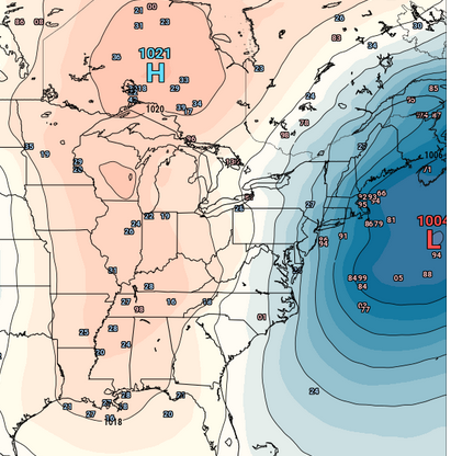
-
January 2026 regional war/obs/disco thread
Typhoon Tip replied to Baroclinic Zone's topic in New England
Not speaking with confidence to any snow this that or the other ... but a significant event, Jan 6-7-8, has legs. -
January 2026 regional war/obs/disco thread
Typhoon Tip replied to Baroclinic Zone's topic in New England
Huh? welcome to the internet, I guess. wtf -
January 2026 regional war/obs/disco thread
Typhoon Tip replied to Baroclinic Zone's topic in New England
And note the complete disappearance of the erstwhile N. Pac. .... emerging +PNA/W. N/A low amplitude height response; may in fact be underdone as this is still an emerging signal. I suspect that to be case.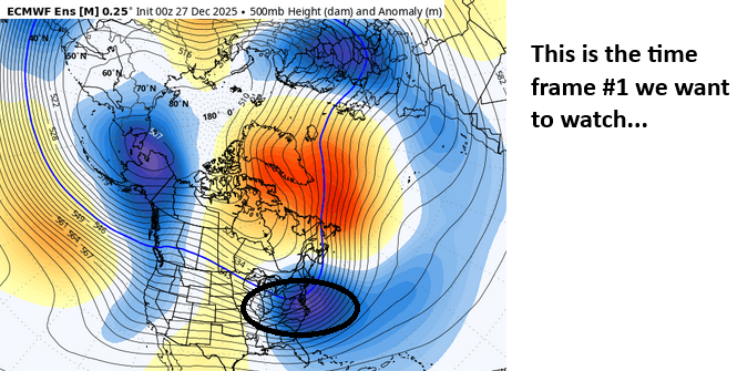
-
January 2026 regional war/obs/disco thread
Typhoon Tip replied to Baroclinic Zone's topic in New England
The indexes are loading the 7th thru the 12th of January, which is well matched with both experience based, as well as recent a-priori on pattern modulation discussed in the ending pages of the prior monthly thread In terms of standard confidence for this range? above normal for +PNA related event(s). Doesn't mean something can't break favorably prior to but from a holistic/all-inclusive field application the front and end of that time range above is the still blurry focus - which means we are free to move it some if needed. I'm not sure about events within the first week itself... That's a modulation time and yes ... events tend to happen when there's big mass-field modulations, but in this case it's gradual improvement of probability from the 1st to 7th ( as in lower to higher). It's almost like the previous pattern resists but then snaps all at once along that range. We'll see how it goes Beyond that's the entry into the weeklies which I find are less useful -
December 2025 regional war/obs/disco thread
Typhoon Tip replied to Torch Tiger's topic in New England
the indexes are loading the 7th thru the 12th of January, which is well matched with both experience based, as well as recent a-priori on pattern modulation In terms of standard confidence for this range? above normal for +PNA related event(s) -
Wounded Duck Strikes Back: Dec 26 & 27th Winter Storm Obs
Typhoon Tip replied to WxWatcher007's topic in New England
Such high ratios, high stack efficiently -
26th-27th event, coming at us like a wounded duck.
Typhoon Tip replied to Go Kart Mozart's topic in New England
The main event! Radar vs the models -
December 2025 regional war/obs/disco thread
Typhoon Tip replied to Torch Tiger's topic in New England
One implicating of losing the -EPO is the relaxation in the flow that takes place down stream over the continent. There's still plenty of cold air around... don't worry. But the upshot is that the gradient slacks off, and that allows the kinematics to conserve at the S/W scale. Right away, the Euro operational run takes advantage of that - whether it is correct or not ( likely not as is - ), the principle of a better pattern for winter enthusiasts immediately materializes there. -
26th-27th event, coming at us like a wounded duck.
Typhoon Tip replied to Go Kart Mozart's topic in New England
Some pretty heavy rad returns smeared out across S. Ontario pressing into Upstate NY. Likely to be an impressive radar display later on coming into the Capital District/SE NY, and as is typical ... you'll look at that and wonder how the hell could that miss. It would be something if one of these times ...just once, it didn't -
December 2025 regional war/obs/disco thread
Typhoon Tip replied to Torch Tiger's topic in New England
The changes are starting out over the vastness of eastern/NE Asia and the relay across the N. arc of the Pacific Basin a bit over a week from now. I discussed this yesterday or the day before whenever that was that the GEPs was first, then joined by the EPS. The wave function producing that resonant -WPO feature out there that has plagued our side of the N. hemisphere is at last depicted to collapse. This is true among all ensemble systems - perhaps more aggressively so in the EPS and Canadian clusters but the GEFs mean's taken some strides. There's a few implications, some speculative... some known - but the caveat being that this all actually takes place. It's really out ~10 day whence the sweep begins... The timing can change, too. By the 300 or so hours out into the temporal range there is an abrupt reversal of the height anomaly distribution over the N. arc up there. Below is the EPS example. Change are coming ... Some very early indicators are +PNA, hinted already above with at least a return of the perennial W. N/A bulge over the Rockies. It's all very primitive.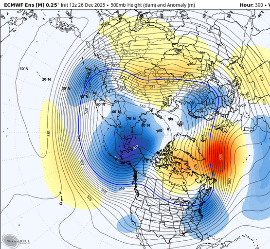
-
26th-27th event, coming at us like a wounded duck.
Typhoon Tip replied to Go Kart Mozart's topic in New England
Hmm a lot of "users" in this "psychotropic crack-house" are not constrained by negations such as the bold ^ ... because it gets in the way of their high. LOL Seriously ... if there were more willingness to objectivity, sans the most jerked off solution, that obvious and true aspect about the NAM would be elaborated upon by more people that just you and I and one or two randoms. But that's not what this engagement's all about. -
December 2025 regional war/obs/disco thread
Typhoon Tip replied to Torch Tiger's topic in New England
You might be in luck … Major guard change signaled in the extended GEPS with coherent collapse of that remarkably persistent and intense -WPO, now being joined by the extended EPS. GEFs lag but I suspect it’s a matter of time …~ 10th+ of Jan This will send the roulette wheel for a turn … at least introducing footprints less neg interfering with the +PNA hemisphere … sorely lacking so far this cold season with that erstwhile signal - other than unstable quickly transient moments. 30th is a good example of this … That -WPO is an unusual/historic scenario and its sending odd wave signatures radically down stream. Need to get this inside of day 10 first -
26th-27th event, coming at us like a wounded duck.
Typhoon Tip replied to Go Kart Mozart's topic in New England
The track on this deal is as set as it can be. Variances that occur are within noise/acceptable error and not really predetermined It's the amplitude and QPF verification that is in question -
26th-27th event, coming at us like a wounded duck.
Typhoon Tip replied to Go Kart Mozart's topic in New England
The whole system seems a bit over-wrought. Wouldn't be the first time the guidance proved too amped ... Then in now-cast the lower edge of verification starts materializing ... Thing is, source-origin and climo. It's not favoring upper ranged numbers. This event is born of a dry sourced polar wave (clipper-esque), and isn't joining or phasing with a deeper moisture source - only the Lakes upstream as a moisture inject ... and it's not physically very clear that's actually being sourced, either. Additionally, it is moving fast. It smacks a little like over-cooked QPF moving above climatology velocities through the area. Could snow hard but too briefly. Will go ahead with the consensus but ... I won't personally be surprised if this under performs by some. -
26th-27th event, coming at us like a wounded duck.
Typhoon Tip replied to Go Kart Mozart's topic in New England
It's conceptually interesting ... who would have thunk we'd be playing needle threader head games on a NW-SE trajectory. haha. wow. Just got back from eve stuff so way behind, but I just remember the runs from 00z last night and comparing to this new NAM run reminds me of playing that game but I've just not seen it from this direction. fascinating -
December 2025 regional war/obs/disco thread
Typhoon Tip replied to Torch Tiger's topic in New England
coming almost straight S ...limited/no moderation before ALB-BOS gets loaded. Kind of a brief 'Montreal Express' looking at the sfc PP. -
December 2025 regional war/obs/disco thread
Typhoon Tip replied to Torch Tiger's topic in New England
Unknown ... to me anyway. I will say that these cold nodes moving across southern Canada and clipping in here have been remarkably well lag-timed with these successive -EPO bursts. Both the Euro and CMC's recency have been showing a Jan 1-3rd cold plume with very deep 850s and low 500 mb hydrostats at the core moving N of Lake Superior ... thru Ontrario in that time range, and we see that 3 days prior there is a negative EPO burst again... it's been like that for that past 3 or 4 weeks. -EPO --> 3 to 5 days later we have ice fishers out there with their portable shacks. Anyway, it's not impossible that -EPO loads and then transitively ...something synoptically circumstantial like Friday morning sets up to then finish the delivery. -
December 2025 regional war/obs/disco thread
Typhoon Tip replied to Torch Tiger's topic in New England
Looks like Ray down to Boston proper are getting some breezy snows? -
December 2025 regional war/obs/disco thread
Typhoon Tip replied to Torch Tiger's topic in New England
Did you see that Friday morning ? holy gelid hell. That's a potent low level cold shot there. I've been watching that interval as it has been nearing and it's been getting colder. The profile is interesting at Logan, Albany and BTV ... all showing the 925 as colder than the 800 mb. -
December 2025 regional war/obs/disco thread
Typhoon Tip replied to Torch Tiger's topic in New England
It's not snow you want ... it's snow depicted for a cinema-dopa connection. It's created out of advancing technology's affect ( and effect) going on with our species. LOL it's true though. If folks wouldn't "bi-polar" dial into the next model cycle you wouldn't have these group collective morosity waves that are more powerful than anything this type of persistent synoptic hemisphere ever had any hope of really delivering in the first place. But this latter aspect ... never seems to stop you. You have a big ridge in the middle longitudes of the continent, with a deep layer circumstantial NW flow - what part of that large scale footprint has ever correlated to significant snow? Not many. Stop on expectation failure one. Failure two, meanwhile ... the mid and ext range guidance give these 'so-so gets hammered' dopa hits, when guidance over all consummately proves over-amplified since antiquity at this point ...and invariably need be corrected down as assumption. This latter aspect has been explained to the point of advertisement. Heads nod, couple blinks ...then the next guidance run comes out and eyes roll back in head and orgasm quivers kick in all over again. The problem is that the return users in here are dopa challenged in their lives - most likely. Perhaps then channeling a means to fulfill it by creating this weather graphics triggering mechanism. Or they've just fallen victim to the "blue-light special" - psychotropic addictive aspect that is proven to be a thing. Either way ... you're allowing this device to dopa regulate you. I feel the former is correct, however, based upon my own experience. I have created hobbies and successes in areas of life that do not require this weather -related stuff. I get joy from those engagements... and, most importantly, when that happened, I stopped caring about the former - or caring as much. I mean... I like seeing the charts and evolution of interesting events. But it's not required. I think if folks understood these aspects it might help them self-regulate their moods better. That's the only purpose for bringing this up. -
December 2025 regional war/obs/disco thread
Typhoon Tip replied to Torch Tiger's topic in New England
hahahaha.... damn! thought I got one past you. That part of it's a chode tug just cause I was being a dick, but I do see similarities among these years whether we/you/I want to see it or admit or not - and... I don't claim that it is CC outright. I am open to that being the case but more seriously, there was a speed/velocity saturation in the flow every one of these years that is/was/still is near the top of the geophysical ceiling during winter core. There's a reason all these air-land airline speed records have been set in the last 10 to 15 years, for those intercontinental flights over the N Pac and Atlantic. It's because they're traveling in the slip stream of mega jets, where they have to open the throttle and fly very fast to maintain lift ... which requires near sonic speeds relative to the stationary E... It's 200 kt 300 mb wind flow ... you gotta move the 60 ton vehicle at 600 mph to maintain the air-relative 500 whatever mph it is they need to stay fuel efficient ...etc. So regardless of the reason ( CC or the CD ) ... It's probably going to be observable in January ...again. It's based upon persistence for now. -
December 2025 regional war/obs/disco thread
Typhoon Tip replied to Torch Tiger's topic in New England
ooh ooh I can help. Image a rope, and your snapping one end ... you'll see a wave move along the rope? that is the linear function/wave propagation. Now imagine that there are multiple wave functions propagating at once. You might have seen this experience in science... but what happens is the waves organize into a patterns that so long as the input force is proximal to steady, will then enter what is called 'resonance' - that resonance is a predictable standing wave event. What we are seeing in the Pacific northern arc out there is a remarkable case of resonance occurring at very large synoptic scale... the NAO that downs stream of that as a secondary resonance node on the "rope". -
December 2025 regional war/obs/disco thread
Typhoon Tip replied to Torch Tiger's topic in New England
Agreed. I added this sentiment to that missive, " It resulted cold loading into the N/A either way so ... who's quibbling. " But also, the Pacific --> N. America total wave signature is what creates the NAO btw. Not you per se, but folks may save some frustration if they finally get their minds wrapped around that. It's the mechanics downstream from the PNA domains idiosyncratic wave distribution. One of the reasons it's so difficult for the models is because it's largely driven to emergence through non-linear function - those that are applying forcing in a transitive interference, which are not visible. Just sayn'


