Typhoon Tip
-
Posts
43,417 -
Joined
-
Last visited
Content Type
Profiles
Blogs
Forums
American Weather
Media Demo
Store
Gallery
Everything posted by Typhoon Tip
-
Looks like the Euro was the better fit... Somewhat better continuity, and layout of general 1.5 to 2.5" is a reasonable compromise between the unrealistic 4-6" ideas, and the relative no-show by some off-on other guidance types. Good win there For me personally ... this was a modest positive bust. I was on the fence about this thing even as the rad was activating on this yesterday, thinking a lot of the western edge/banding might have trouble getting down to the earth. Higher pwat in the area may have helped this facilitate better surface realization.
-
Exits with significant wind too
-
Heh …

-
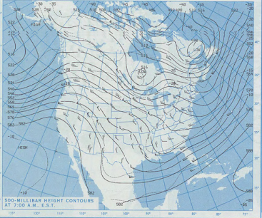
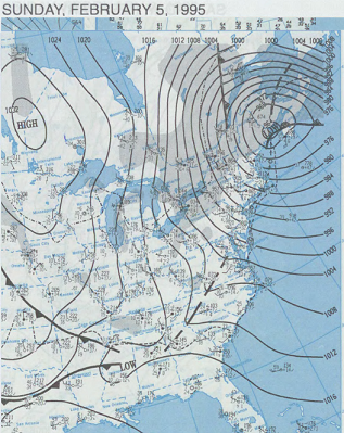
Heh...if it makes you feel any better ( probably not... ) that event had a fairly low probability for a positive return all along. That said, it's not sealed in fate just yet. That's still 4 or 5 days away. It's hard to maintain an objective vigil ... when there wasn't one to begin with hahaha.. No but, given the winter we've had, makes it sort of difficult to imagine anything working out really. It's been a little uncanny thus far? I wanna hammer it harder but I can't, not based upon decades of experiencing ups and downs. I remember a winter in the 1990s... right in the middle of a fantastic decade. 1994-1995. Man, that year stood out as numero uno sore butt year of all time... Until 2011-2012. But ...actually, both years had at least one decent event. The one in '94-'95 was a February 5 coastal bomb. Storm went from like 1004 mb to 970something in 10 minutes. It was too progressive to really be a big dawg, but there resulted 10 to 18" totals around the region, nonetheless. At peak strike, up at UML ... I recall est 1/16 mi vis snow/wind combo. It ended a remarkable streak of horrible luck though - in some senses, it was worse than this year, because first of all, that was the first snow of the season that really meant anything anywhere ... a bit later than our current plight at Jan 15. Secondly, much of the season the pattern was characterized as a 'low amplitude +PNA'. It looked from orbit like we should be doing better but nothing would ever break right. The persistent pattern just looked similar to this for 60 days prior to the coastal bomb... ...resulting in nothing... From orbit, that seems it shoulda been better. Not sure if it was warmer than normal ...I don't recall. I just remember the pattern looking similar to that above, unrelentingly too flat to actually do much of anything. Then this happened...
-
Bingo ... A bit early for me, so ...I'm not saying I'm entirely there - yet. But my patience is wearing thin. It also has nothing to do with whether I can be objective about where we've been, are at, or are going - but I am a realist, and it does grow more difficult to maintain interest when uninspiring nuance is controlling every outcome. By the way folks, nice quasi 2005 Dec analog on the 12z Euro 7.5 day... ha, in contrast to the sentiment I just leveled above -
-
Is very much of this even reaching the ground down there ? I'm wondering because as I've driven around town up here in Ayer, looking S, there's virga plumes ...I'm wondering if much of this under the western edge is a virga event, or will turn out that way. That's not uncommon for model error in backed deals, to see/think virga is ground materialized. This should be a great sunset day, by the way.
-
funny...I check it out, mainly just for popcorn and coke. It seems to always have a more preferable solution in winter day-to-day runs, than the GEFs. I almost wonder if that's because the climate USE to carry on with more preferred solutions. Ha, so it is mixing that up with the shit we eat in the more 'organic' now-climate. Lol
-
fozz is an urban word for what modern vernacular already had devised a term for, 'shart' Imho, it's not a good emoji to have made available. It's sewing dissent into a powder-keg environment with too many that are precariously too close to being mentally too irresponsible and it will ignite - obviously! It smacks as "wanting" the vitriol... because logically, it does not otherwise offer anything. Regardless of what motivated ( eh hm) this may be minor but is still incrementally adding a "crassification" to an already diminishing return.
-
Mm... I'm starting to raise miss-givings. I think that ridge is too far west - and perhaps silently worse, has been retrograding west relative to the nightly mean ( each night, the ridge axis is bumped a little more west). It could come back east...? sure. But for now, that is really on the western edge - any more and that "clicks" the hemisphere right back into a -PNAP overall ... ( Something no one in this particular social media pastime probably wants to envision, but if this horseshit continues into February, warm enthusiasm et al should have a good feeling for early spring. ) But back in the here-and-now.. that can still work out. if the system frequency is characterized by middling S/W mechanics. Those will tend to flatten out and still conserve enough to eject successful events up along the ambient polar boundary -...probably situated STL to NYC in that look. However, should anything of greater mechanical space arrive in that layout ... it will cut to the Dakotas and back east will send up early crocus spears.
-
Yeah I don't carry any illusions about whether I had it or not. I had some early-on Omicron thing back last April, like everyone else ... in spite of being squared away with immunization protocols. It struck me on the second day nigh my sister's death at the hands of an aggressive form of cancer. Like who has a week like that? Maybe someone eastern Ukraine? It was a mild head cold, otherwise felt a little lethargic maybe. Really nothing to write the relatives over...lasted all of 4 days. I tried to reengage with normal life, which is daily ( almost ) regimen of cycling ...running..etc but my right knee locked up. Just woke up out of the blue with half immobilization and lot of pain. Turned out, joint stiffening is descriptive in the Omicron symptoms - or can be. It took me about 1.5 months to get back to regular work outs, and to this day...I still feel I've lost something and haven't gotten it back. Since then there have been other sub-variants. This latest identified,XBB1.5, is so-called, "immune evasive" - sounds like hyperbole BS to me, if not marketing. All of them are evasive at first... Oh but I'm sure that gave the "COVID industry" a little more longevity. This may be kind of a simpleton question but, if it is evading than it is not producing antigens ( right?) ...wouldn't that cause these home rapid test kits to become even more less useful? The COVID story likely never ends ... More like fades away from public interest by acceptance. It'll be impossible to catalogue, if not unnecessary due to the attenuation arc. The mutation tree becomes too diverse. Eventually "medicine" and media will disconnect because the latter can make more money selling celebrity affairs - you know, the actual important stuff. Yup, our species is destined to live in an ambrosia of variants ... You know...I can't recall the exact percentage but I think close to 50% of the human genome has ERVs ( indigenous retro-viruses) now permanently a part of our species heredity. 50%. The survivors of "millennial COVIDs" transmitting their saga a 1,000 nth generations henceforth... Kind of makes you wonder when your looking into your sig others eyes in the afterglow of a good orgasm, 'what did I just make love to?' ..hahahaha.
-
I tested negative … 3 different times with 2 different rapid test kits. I’m not sure those are entirely accurate. I’ve never had a head cold nag on undeterminably like this. It started on Dec 29 … still whoop coughing.
-
Euro needs this. Even a little coup. I mean I suspect folks are too hard on it - debatable. But you know even a 1-2” band puts it ahead of the others.
-
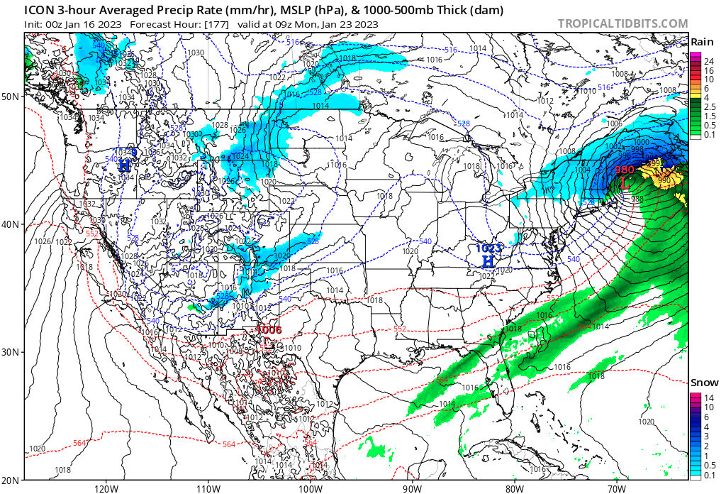
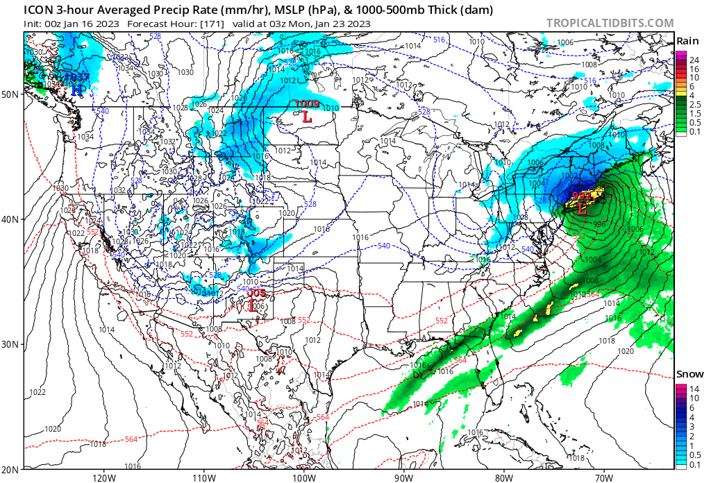
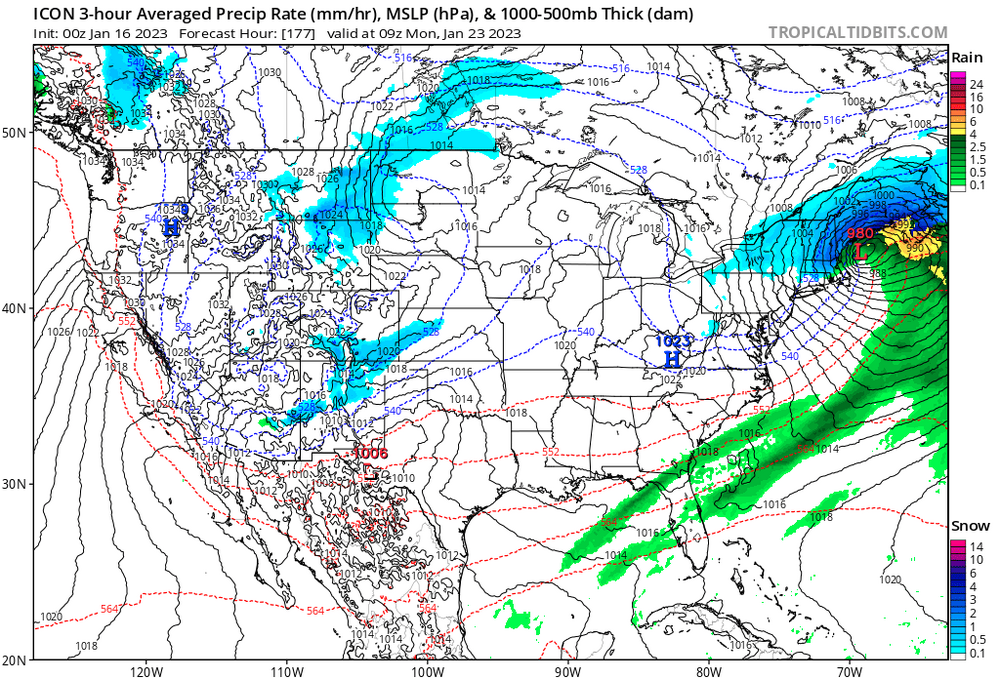
I'm not sure it is ( to me ) however, with the NAO diving and having the ballast of it hanging over the western limb of the domain. In fact, it's almost back to JB... between there and the D. Straight. This thing doesn't appear it has room to go N. Looks like a Minnesota squeeze, but it may not even get that far N before it squishes east. We'll see, but I'm about to pull the trigger on a thread. There's a decent up side, because it's riding over the top of a flat ridge, which means it will have a PWAT source hoisting over what cold there is - so long as the boundary stays along the Sound. This year's debacle requires a 4-6" event be cited. re cold... The Euro is substantially colder than the GFS in T and DP. Meanwhile the GEF NAO mean leans on the operational version as too warm in the BL C-NNE. So/if the Euro closes off a 2ndary between the eastern tip of L.I. and CC Bay, that'll tug S - speaking partial between depiction and imagining the correction. Waiting a couple cycles... thinking late Sunday if it still looks this way I put one out. I also suspect the subtle progressive bias of the GFS might be damping the mid levels or wholesale the event, or both. It's a battle between that concept and model magnification, admittedly.
-
haha... for what day, and what time... you do realize ...the model depicts 13 days worth, every 6 hours here , start with this: https://www.tropicaltidbits.com/analysis/models/?model=gfs®ion=us&pkg=mslp_pcpn_frzn&runtime=2023011418&fh=72
-
what day and time?
-
I wonder if folks were having these discussions on Jan 14, 2015
-
I agree...
-
It's going to be hard to do much with 23/24 if there's really a west wind thru Ontario and Quebec before it arrives.
-
CNE ski areas probably do well with that IVT/e flow lingering ...
-
Anyway..by a narrow margin the Euro's SWFE keeps it mainly snow N of the Pike... But it's real tight. Like 10 mile wide IP, 5 miles of ZR and then R in CT/RI.. But the cold/BL resistance is working magic ...forcing secondary, and once that happens everything collapses to S-
-
nnno, it's not merely semantics. In regions where it snows, they are going to snow more likely in a pattern that is both numerically and spatially in +PNA, with leading and/or concurrent polar indicators, than otherwise. It's better just to realize it is not 1::1 and not try to cripple the correlation with moderate this or weak that or any of those adjectives. Correlation is not causation blah blah..but it works both ways, and that is why the correlation is not 1::1. The blunt difficulty and frustration here is really that we are rolling bad dice right now, and it is driving people to agitation, to question the conventional method. No matter how articulate we pen our turn of phrases. We can "maybe" offer speculation that CC is having something to do with it ?.. Sure. I actually don't have a problem with that, but that's drifting in the discussion, actually.
-
Yeah...but we're not regressing if we're in a different climate. That's the point. Once we've differentiated into a new paradigm, there is no retrogression in the sense of fixing or 'correcting', because that retro no longer fits the a climate the region is no longer a part of. It's looking at apples and oranges comparing the 1980s to now, really. The results may be the same, the the cause is not coming from the same aspects. So presently it is warmer than normal almost unilaterally year to year, as well ... snowing with a different behavior. We have a higher frequency of big events, ... separated by longer periods of non-events.
-
mm, I wouldn't call the correlation weak. It's just not 1::1.
-
yeah..I dunno. I'm starting to internally materialize miss-givings about the climate use in the discussion. Those 50-60" might be tainted by two aspects;I start to wonder if they belie the 'real' climate? In other words, that 'reason' is defaulting more and more false in this speculation. We are getting 'spike' phenomenon event/eras, more frequently than we used to ... along a mean of more abysmal productivity years. Those spikes are huge, too. Like the increase in the 12+" storm frequency. Or 2015 ..etc. Those skew the averages higher, perhaps - speculation part - more than the "mode of expectation" should really be. You could almost parse out, 'our climate suggests lowering seasonal snow totals, with offset years being much larger still a possibility' - something like this. Which really requires a deeper qualitative analysis than using the 30 year mean of snow... etc... If that were true, objectively it doesn't make a lot of sense to think we're eventually entitled to 50-60" years The other aspect... the climate's been changing fast enough that 30 years may also weight the average falsely, anyway, regardless of 'spikes skewing means as speculation'. I've heard these recent years ...well, basically since 2015, sort of compared to the 1980s? Ah, having lived that decade in full sentient awareness, I can tell you this is different. We are doing so now, when 7 out of 10 or even 8 out of 10 months are routinely above normal temperatures... Regardless of ENSO this, or polar index that. The daily cents in the till, are adding up more proportional to seasonal dollars. Mm...sorry, that barks CC having a hand in matters. I'm starting to wonder if at planetary scales, we might get around to seeing a year that leaps... where its not only the warmest in history, but it does so by more than 10th of a decimal. Just more speculation. I just wonder if our snow climate bands are not really what they presently are.
-
But ... in any case, there are couple of events to monitor in guidance that are not really a part of or immersed in the d(pattern) consideration. 19/20 and ... circa 23/24. ...hard not to assume lesser returns on investment, given the road and unrelenting persistence to do so.. The 18z run of the GEFs mean was probably the best of the EPS/GEFs last 3 cycles, which unfortunately ...nods to the assumption. But we'll see