Typhoon Tip
-
Posts
43,417 -
Joined
-
Last visited
Content Type
Profiles
Blogs
Forums
American Weather
Media Demo
Store
Gallery
Everything posted by Typhoon Tip
-
Posted earlier ...they're having comms problems - they released a statement this morning.
-
what does that mean ... RUT is interior "New England" oh never mind - this was yesterday... haha
-
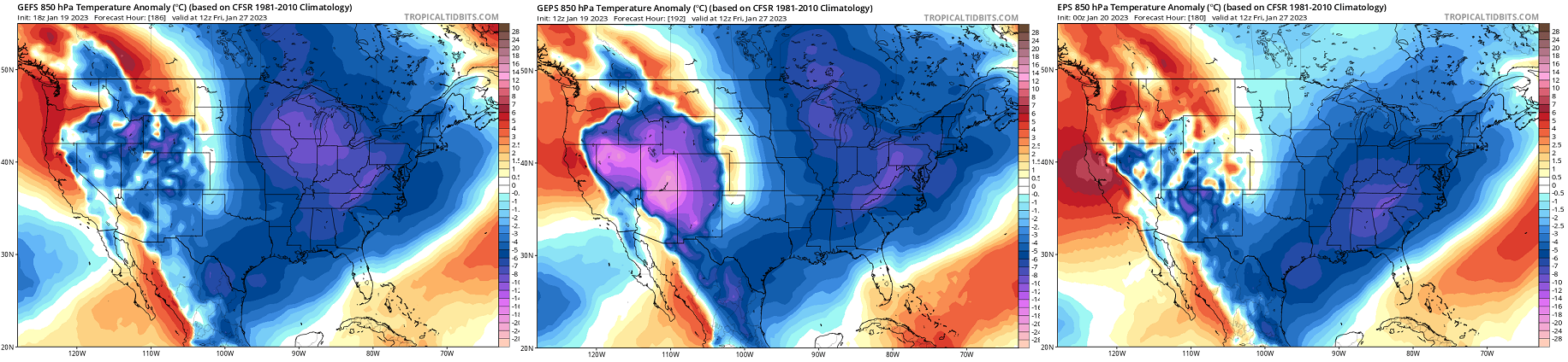
Fwiw, the 12z GEFs members are tightly clustered with a track SE of the operational, and with a colder profile for Monday. Looks like the 0C 850 mb isotherm collapses SE between 6 and 12z ..ending up PVD-BOS, as the system makes closest pass
-
FYI - SENIOR DUTY METEOROLOGIST NWS ALERT ADMINISTRATIVE MESSAGE NWS NCEP CENTRAL OPERATIONS COLLEGE PARK MD 0532Z FRI JAN 20 2023 ...INTERMITTENT CONNECTIVITY ISSUES... Intermittent connectivity issue with various websites starting around 03Z, including ftpprd.ncep.noaa.gov, and aviationweather.gov, and forecast.weather.gov. NCO support is investigating. Please visit https://www.nco.ncep.noaa.gov/status/messages/ for further updates. Liddick/SDM/NCO/NCEP
-
As of the lull this morning .. 2" on the dot here. That makes my seasonal total very close to 9" We'll see how we stack during the day. Right now, steady light snow has recommenced. 32 F
-
Euro suggested the same thing the NAM is over it's last two cycles, as well. Both are trying sting the CCB, collapsing it back through the region later Monday.. It's likely going to be over QPF'ed if that happens.. but, I just thought it was interesting that they are attempting to do that. Euro version was the more impressive, too.
-
You know ... re the pattern change. I've been watching this aspect that last couple few days in the ensembles ( cross-guidance). It's possible some of the smoldering consternation is also self-afflicted. Why/what I mean by that is, we've been perhaps rushing this no sooner than it was sniffed out as even plausible some 2 weeks ago. That is/was not helping matters. We are/were less likely to manifest any system prior to the 27th as being winter enthusiast inspiring... That 26th system appears to really be an '850 mb inflection' event. Beyond which ...the span of the 40th to 60th latitudes, from B.C. to NS, descends en masse to below normal/negative anomalies. Prior to that, the pattern may be augmenting ( or not...) in the 500 mb isohypsotic layout over the local hemisphere, and in a lot of ways that can be pointed out as being the case - suggesting the d(pattern) is actually taking place... But, I think as far as both sensible/experienced weather, and... being able to manifest systems that are more in the 'like'/d-drip potency ( LOL ...) ...seriously tho, we were not really favorable prior to the 27th, particularly over the eastern continent. Around that date for this flood and mass field significant and deeper change has been very consistent... Prior to this ~27th critical inflection timing ...we've largely been manifesting events in layouts more consistent with this... This latter thermal layout is more apt to present challenges for realizing wintry appeals. We can't walk through a landfill and be surprised that it stinks. The cards are stacked against us... Pick a metaphor. One aspect I am also noticing is that out there around the 30th... there is a bulge of 850 mb temperatures ( more aggressive in the EPS ...which makes sense for it having a meridian bias in that range), where/whence the neutral line gets to about ORD-BOS before collapsing SE. There may be significant event in there. By that time, the cold is established, then that bulge transiently passes through...that's an opportunity. I did take a peek at the individual members of the GEFs and there are several members (below any consensus, still ) that are interesting. But, otherwise, ... that looks like this winter bottoms out in the first handful of days of February - we'll see if the period suffers model "magnification correction" as it nears.

-
I dunno... that 06z GFS was too close to an isothermal hammer over ORH to dismiss Monday's system. The heavier snow axis is likely ~ Capital district of easter NY up through the lower Greens/Whites, but I'd put a wild-card band between that axis and ~ ORH and wait it out through the weekend runs. That's like a single tick from being 6" of dense paste. Threading the needle 101
-
I find it personally interesting that the NAM is like that considering it typically has a Northwest bias at that time range… Really anything over 48 hours yet it’s the most southeast solution
-
00z NAM looked like 3” over metro east
-
We flipped back to rain 2 hrs ago. Once in while there’s a ping or two against the sills … looks like the bigger drops are cat pawing too. I noticed on P-type rad it’s snowing on either side Methuen right now which I find to be rather remarkable.
-
Ha. At present moment … ptype rad indicates it is snowing on either side of Methuen … it’s really quite remarkable
-
When was the last time the NAM scored a coup - gosh...I think back to 2005 really. Not sure I recall since -
-
Just flipped to gritty slush snow here about 20 min ago. Very quickly the roads turned gray and turning corners tries to tale a bit... It'll get slick in a hurry folks. 33. Some kind of S-/R- mixture at the exact moment though.
-
Wtf i’m looking at the synoptic charts and I’m not sure I see how it’s going to snow anywhere close to that much south east of about an Albany to Fryeburg Maine line The events depicted here look like they’re moving too fast with shredded out ptypes and amounts
-
Just need that girl, the real reason I even came to this party of dead-beats ... to grab my attention before I'm out of reach and pull me back in. Like that end seen in Something About Marry ..ha
-
I was almost speaking to the straw man ... in the off chance that there are those not clear on the concept LOL I'm half out the door - admittedly ... if prematurely.
-
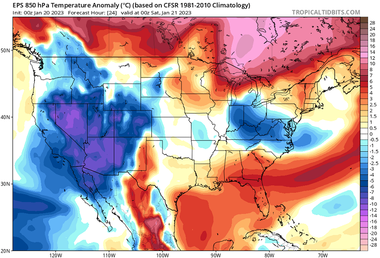
'now cast' appearance on the entry into this thing ... the snow appears a little more aggressive on various p-type outfittted rad presentations compared to modeling. just sayn' not sure if an obs and amt thread is worth it for this - but ... Looking around ... WPC's current sfc synopsis shows at 16:30 there's a weak cold front slicing through the region. It's hard to detect this in sfc ob/wind profiles, and the DPs are also not very representative, but it is what it is. This situation being very sensy ...it 'might' matter? Right now up and down rt Poop we are generally 37/28 ... Rad with ptype suggests very quickly going from nothing to some sort of light to moderate fall rates, whether IP contaminated snow column or snow. But that's evidence along a line roughly SYR-HFD
-
I prefer to just maintain an objective vigil … But I suppose as an approach to this engagement either method is probably going to end up in the same mentality - semantics. Having said that… gosh, not a good series of runs last night regarding any of these possibilities we’ve been tracking over the next 10 days – essentially in one run the consensus depiction wiped out multiple cycles of trend towards better solutions for winter enthusiast. Such is life in the dreaded needle threader circumstance… which naturally means that there’s some probability they’ll come back obviously It may snow in those systems. But obviously all can see it’s way out towards the capital District of eastern New York up into northern New England… That’s just the winter we’re having thus far, even if it hasn’t performed particularly well N-W, either. It seems the model runs last night just clicked back into the trend of the season… Mm part of keeping an open mind is being open to the possibility that nothing will happen – just sayn’. You know if I have to be blunt even the pattern change itself more so looks like it’s got short legs on it… So others have intimated this over the last couple of days. I’m not sure I disagree. The long awaited new paradigm may limp into the first week of February after which I don’t know. Hm if we really do slip into a negative PNA sans blocking there’s nothing about the last 10 years of climate that suggest we won’t soar into the 70s for another historic run of it next month. We’ll see if an extension corrects in, going forward
-
On a somewhat funner note ... beautiful display of 'Red sky at morning...' earlier.
-
This story still has two chapters. This evening/overnight. Friday. In chapter 1, the recent NAM pulled the rug out on anything very meaningful along the Rt 2 population ..although perhaps better out there toward Orange... The model had shown very solid continuity for about 6 cycles actually, then 30 hours prior to go time, that changed. Not sure continuity principles apply to higher res meso models that are exceptionally sensitive to almost imperceptible perturbation - you can't be sure they are picking up on something real, or eating contamination that's too subtle to notice but having a disproportionately large forcing on the solution. Still I'd like to see one more cycle do this warmer solution. Otherwise, ..nothing's changed above and below that rough latitude. This was never - in my mind - going to show along the Pike. Meanwhile, these changes in the NAM, if they hold ...probably don't mean a helluva lot from roughly RUT-MHT-PSM. The reason I'm citing the NAM so much is because this event had that over-arcing theme of suspicion that it might try to bump N in short term. It is sort of annoyingly predictable, hut ...we'll see. In chapter 2, there may even be a lull early Friday a.m., then we'll have to now-cast where destabilizing lapse rates working in tandem with mid level jet near-by blossom/fill-in rad during the morning. Looks like light snow that isn't very proficiently accumulating, with perhaps a lucky stripe or two that pushes 2-3" ? something like this...
-
00z NAM with .6” liq equiv burst
-
Funny … this was originally supposed to be a Friday thing for SNE. Folks seemed to will Thursday night over the border… If it goes back to original heh
-
That ends up in Buffalo ..but it's a helluva look at this range - ha. "Miami rule" in full effect on that run, too -
-
That's been repeating as theme across the last several cycles, btw -