

Typhoon Tip
-
Posts
43,386 -
Joined
-
Last visited
Content Type
Profiles
Blogs
Forums
American Weather
Media Demo
Store
Gallery
Everything posted by Typhoon Tip
-
Wait tho- how does Boston having abv normal snowfall in 6 out of the last 10 years successfully abase what he said? Just as an example, there’s a new climate signal for single event results that are so extreme that one or two of them in a season can push a location to or even exceeding seasonal normal. I guess it all matters snow total then? I guess… for me if it’s 60° 80% of the time and you get two big snow storms that doesn’t cut it but that’s just me.
-
Yet that never seems to trigger an objective brow raise amongst his constituency
-
you have the right idea. I mean grass is one of the worst things for the ecology - there’s been a wave of citizens for global vision type rethink on how people manage their property in the past 10 to 15 years. Lol I’ve come to find people in here are the last to know about this wave of thinking. “Green” lawns should have rock gardens, and non-treated mulch and perennial plant beds and garden boxes - all of which can be done in aesthetically pleasing ways to the point of even art Re the gas powered mowers. Tough shit. Wahaah. Jesus there’s nothing wrong with electric mowers, though… Couple neighbors have rechargeable bat powered ones and they work just fine. Granted you’re just moving the carbon footprint to a different location - for now. But with more and more renewable energies feeding back into the grid eventually that will offset that “hypocrisy”
-
heh.. 12z GFS has no pattern. Above and below normal with irregular oscillations and lengths of time. Guess just stick with the ens means for now. Whatever they're showing... but even the wholesale means are giving competing indications.
-
I see what you were looking at now. Yeah, may be a warm interlude - I was looking past that. Lol. gee, what's on my mind - But the GEFies had been indicating a +PNA toward the 20th. Thing is, it's like a "warm +PNA" ? Cool circulation type amid a modified hemisphere. In other words... inCREdible boring. Could use a -EPO burst while/if/when we warm in the foreground, otherwise that's liable to host cool rains in between mild days toward the week of T-giggedy...
-
Really…? I thought the opposite. oh well better for me… I’ve got a disc golf tourney at the end of that week.
-
I wonder with this scunge cloud debris if some of the mild potential today is being robbed.
-
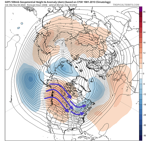
Not entirely but doesn't hurt. The "cold loading pattern" for north America is really before that. When there is a ridging over the Berring Straight through the Alaskan sector, directs a cold conveyor/delivery over the western semi arc of the polar domain, which dumps it down stream over western Canada ... Eventually is sprawls out across the continent. The PNA then moves toward +PNA mode ... completing the destiny - which looks like this below. You can get a sense by looking at this above, whatever cold air was erstwhile delivered over Canada, then gets directed south into the U.S. That's more or less the idealized model. Above is a positive PNA look. The typology of the +PNA layout is usually negative height anomalies N/NE of Hawaii, with downstream counter-balancing positive anomalies over western N/A. Check. Somewhat intriguing considering that chart is 10 days to 2 weeks out in time, and these features are so coherent. That's not exactly hinted there. Notwithstanding, 330 hours. However, given success, that would probably be a stormy look - an assessment that comes down to emerging in the positive direction. It's getting more advanced in the discussion but when on that side of the evolution, fun stuff is more likely to take place.
-
Interesting ... the GEFs appear to be playing catch-up to the Euro weeklies of all things. Long range/mid month hemisphere looking increasingly +PNA-ish
-
It's the perils of progressive patterns. Error is much higher. Here's the deal, ... the GEFs PNA index end ups rising from -.5 to +.5 between now and Nov 15, doing so with surprisingly limited spread for both the time of year but just considering going all the way through week 2 in general. There's no "spike" there...just a gradual ascent. A pulse at some point along space and time signals enhanced restoring system potential. However, NJ model low and/or flat frontal wave type events take place beneath the large mass field perturbation. The restoring is triggered within smaller nested domain spaces below those larger scales. The PNA is so massive a domain space, a NJM wave eject, out of the eastern limb, could fit along a more gradual sloped ascent like that. . To be fair. The WPO/NPAC/EPO ... are sending warm signals. However, the +PNA/ +EPO correlation, particularly post -EPO bursts ( like last week) would tend to be colder look of N/A as the +PNA forces NW flow through the NW Territory - the negative EPO damage was already done. Which we are seeing. Check... So..it's not clear what the upstream N arc of the Pac has in mind or if may overwhelm. I think what we are seeing in the guidance is sensy 'giga' movement because of that.
-
Layman, Yeah what he said ^. Sorry I didn't back to you - it's officially shit month at work ( apparently. F!) The only thing I'd add is aspects like the trop. forcing and/or ridge placement that he's mentioned? - those are also changing in time. The models can error with those different regional mass-field influences. Which would of course then introduce error in how the main ridge and troughs ( the pattern ) ultimately situate. To help with some that, the ensemble means are used. They tend to be more reliable at outer time ranges, because by averaging all those solutions smooths out the individual aberration/oddities. But even this method can be screwy at times -the transition seasons can see wholesale 'redraws' at times. It's the major reason for error in the outer mid range ( D5-7) and extended. More often times a consensus in the guidance that seems to routinely materialize right around D4. In recent years, we've seen poor consensus among the models even 2 days ahead ... owing (probably) to the fast flow bias in the winter hemisphere's that's been observed over ~ 1.5 decades. This go of it was more subtle ... The N Pac was transiently lowering heights northeast of Hawaii - and still are really... This was creating more of a +PNAP ridge response downstream over W N/A Rockies in previous run cycles compared to 00z. That lent to more trough over the OV. "Constructive interference" - or perhaps less destructive works too. But last night the heights were made to be flatter over the western continent... and on and so on.
-
Wholesale change swept through the guidance. Maybe the writing was on the wall? Not sure... but the previous 0z cycle was 'strange,' before the 12z (yesterday) attempted to bring certain aspects back more coherently again.. The idea being, sometimes the scaffolding wobbles before it collapses. Sensitivity appears to be the west and north Pacific handling. This run made a significant move away from the AB(cold stormy N/A) to the AA (mild/ flat N/A) circulation mode. It's aggressive enough that it's sending opposing wave signs/negative aspects through a region Will and I were musing over ... forcing a positively tilting victim of destructive large-scale interference... I suspect that is what Kevin's referring too. Will an I were impressed with that structure in prior guidance etc. Anyway, this is an interesting change for nerds.. That's an usually massive difference in/for one run. We actually end up with a zonal flow/ridge compression over mid latitude continent out in time, and that could just as well be a prelude to warm up mid month. Typically we meet continuity breaks with skepticism... but this change was the entire hemisphere from Japan to the Atlantic - what could change that much mass inertia, and just be a burp run? I dunno here folks. we'll see
-
Oh shit yes ... That's not the first time I've seen that sort of hemispheric scaffold like what he posted, from the GEFS/GEPS as well... Sometimes the autumn patterns don't parlay as well as they did in 1995 ... granted. (obvious sarcasm). But if speaking what-ifs, agreed. If we're doing this in the core I think a few locations would go a considerable distance toward fixing their apparent decadal snow fall deficits, up.
-
That is a f'n beautiful construct presage to a NJ Modeler dude. wow - I know I have been hitting that storm type rather hard as of late, but I think ( full disclosure) this is a ripe 10 days for those flat wave rapid detonators ... beginning this weekend and through next week. Could be two of them ... hell, go 1996 on dem bastards. It doesn't take much when you have that ^, happening post a -5 SD EPO burst (last week) that collapses into a rising PNA like we're seeing spanning the totality of October 25 - Nov 10 - I mean IF that were to take place a month from now I said at the time, the only hold backs were the time of the year... However, seeing this air mass snow so easily in CT... and having 0C lower than 925 mb with orb sun no less, got me bun-able today
-
Guaranteed a few individual members have majors M/A to shore NE given the morphology of that +PNAP trough amplitude over 300 hours there
-
It's also pretty cold all the way down to 2000 elevation, too. -0C at that level and -6 at 850 ( I think I saw but check that). Anyway, fall rates don't have to be very heavy with a cryo altitude that low.
-
Definitely room in the Euro for that to come south. The mid and upper level hemisphere through that synoptic period has a barrier vortex look over central/E Canada, and the Euro just from person experience over the years will often times overcome by attempting erroneous early phase.
-
I'm kinda of nice about it in Novie. I don't expect much, either ... It's not like that winter anxiety we're denying on January 12th because of a so-far seasonal snow total of a whopping 5.4", while the models are urinating thaw patterns in the extended. We got "blue" thickness within reach if not accessible, with an active pattern? I'm good with that
-
Classic NJ Model low depiction on the 12z GFS ... classic flat wave quick mover. Middling intensity but text book's aren't really bombs either.
-
Yeah that trough amplitude was in the 00z mean, too. I mentioned this morning that the ens means were (all 3) apparently emerging but I haven't had a chance to take in the 12z. I did see the operational GFS (ew) and got pissed. Lol
-
Life and actual work are preventing me from being very involved, much to the satisfaction of the collective, I'm sure... but clearly there is some sort of move by all three ensemble members toward the coast for the 8th-ish of November. The telecon spread/leading modality's are not altogether terrible, something seems more likely than not to be emerging along the M/A. There is spread (of course..) at this range so keeping an eye on it. The other issue is that it is less than clear what/if/where cold air
-
Octorcher or Roctober 2023 Discussion Thread
Typhoon Tip replied to Damage In Tolland's topic in New England
The Plains getting cold and dumping a blue norther into Texas, and all that is probably more normal than not down wind of a -4 or even -5 (depending on the source ) standard deviation EPO that burst forth some 10 days ago -
I know - right? Look, I'll say it for the 4th time: if snow making were to be done "green" than who the fuck cares?! build a goddamn glacier. You know, logic dictates the only reason to really argue has nothing really to do with not believing in climate change, it's really about being told to stop.
-
Actually fertility rates are down all across industrialized societies throughout the world. I don't know if that constitutes "stop making people" ( lol ) but it is down. In fact, I've read that China is actually losing at the other end at an alarming rate. And I know the U.S. is below the 1::1 balance - in other words we're losing to more than gaining. Just adding this
-
Bingo! I sometimes think the "politicizing" thing has become an act of diversion from facing the real argument points.


