Typhoon Tip
-
Posts
43,368 -
Joined
-
Last visited
Content Type
Profiles
Blogs
Forums
American Weather
Media Demo
Store
Gallery
Everything posted by Typhoon Tip
-
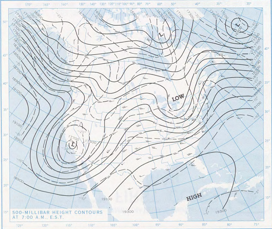
That sucker went deep at 500 mb. That pattern during the week preceding did bear some resemblance to what's been modeled for/during the first couple of weeks of this March. 4 days prior to the 17th, 1973
-
Yeah ...the telecon spread's are not exactly warm with no variation in sight. primer: warm patterns in early spring tend to synoptically self-destruct. They get kicked out of the continent and end up pooling in the NW-N Atlantic. That forces the -NAO. Heh, if you are a responsible-minded warm enthusiast with a modicum of longer vision, you don't want for these early "winter heat waves" Anyway, seeing the teleconnectors in fact dropping the NAO negative post the 9th has that historical element to back it. But it is not just the -NAO. I mean, the -NAO can be biased over the eastern limb for example. When that happens it's more of a factor for W/NW Europe. Very recently, the ensemble means have retrograding positive anomalies (500 mb hgts) from Greenland through the D. Straight - it's a long way out but that is very tentatively in support of a more westward blocking. Meanwhile, the PNA flat lines - the trend of which extrapolates to it becoming positive. At that point ...warmth's rug is likely pulled. So we'll see. This could all wholesale change. March is one of the more unstable months of the year due to seasonal change. The t-spreads discussed above actually had backed off yesterday, but have come back since. So those broadly canvased indicators are showing some instability. oy
-
It was a Flop... February 2024 Disco. Thread
Typhoon Tip replied to Prismshine Productions's topic in New England
Man, the wide eyed slack-jawed expression of the Chicagoan warm weather enthusiast has got to be a hilarious sight to behold as they stand there gazing in disbelief. 50 F colder today than yesterday. That's just not fair hahaha I mean, the "cimate cold front" is typically a 25 F correction. They're getting double-donged for this quota. Although... actually, big short term corrections are more common out there in the Plains. I remember my grandmother once told me of going to a matinee one Sunday back circa 1940s, down in Dallas Texas. She was telling me about the so -called "Blue Norther" She said it was close to 80 when they entered the movie house, and just 19 when they left ... donned in summer apparel. "Your grandfather was wearing just a short-sleeved shirt." -
And are pernicious to the surrounding ecological health, too. We've talked about this in the past ( it's obviously not the thread for it so keeping it brief), there is a movement in 'property aesthetics' that is derived from enlightening to that awareness. It features creative uses of rock gardens, draped and or garland with mixes of low-flowering species. Single species aspirations in lawn care is completely and utterly dip-shit obvious - to be blunt. Forefathers ( like your aristocratic vision...) didn't know any better. It was always based on ignoramus and/or predispositions surrounding inherited fancies, didn't occur to anyone as questionable. Unfortunately, now exposed as being shit. Fair, and most importantly ... diverse competition in the ecology, that is what breeds health - not just the systemic health, but the contributing species are also healthier.
-
https://phys.org/news/2024-02-world-stem-surge-polluting-trash.html ...while we are busy cutting the pie into slices of who-dun-what in the causality of the climate holocaust ... this above is just a problematic. Man, despite all conceits ... the evidences continues to mount, human innovation as a weapon unto itself, appears to be its greatest achievement.
-
We just saw the scaffolding of the pattern for next week change over the last 30 yours of modeling cycles toward what your suggesting. yeah - What was once a strong continental front slated to sweep away the mildness early next week, is now looking ( weirdly so...) like a summer front bumping into a WAR resistance and washing out... I mean it cools off, but there's suggestion now that heights and ridging may attempt to roll right back in toward the end of the week. Relatively new... Meanwhile, the EPS/GEPS/GEFs have all brought back the -NAO look, but when they brought it back, it appears to be 2 days later. Mm ...wondering if there's going to be some can kicking here.
-
Still funny Anyway, I don't believe the idiosyncratics of the increasingly more difficult to explain pattern behaviors existed 100 years ago. That's a smoking gun - everything precipitates ( no pun intended ) out of the pattern noise of respective eras. I don't believe the circulation modes of today would have been observable 100 years ago. Different inputs respective of eras makes the comparison ...not as extreme as 'apple to oranges' ... Call it apples to pears. I mean they are not hugely divergent in a comparison, but the circulation being effected is already papered and peer-reviewed. The business with the HC ... to the mean winter PV of the AO domain ... all these fields are verified as changed(ing). 100 years ago is in an extinction event - tongue in cheek intended... It's a question that cannot ultimately be resolved here, though ... Because we do not have access to super computers, nor the advanced reanalysis techniques. To mention, the millions of initial condition data points ... I mean there's a dizzying array of tech and touches combined in preprocessing alone just to initialize any kind of imagined environmental computation - such that could predict 100 years ago vs today with very much confidence. All that would be needed ... Where is the wherewithal, it is happening. There's attribution papers being published. There is unfortunately, also "attribution" being floated by dubious credibility. And the Industrial Media Complex? the minute news and information went up for sale some 50 years ago ... humanity was probably doomed - but that's a wild digression.
-
Don't have a problem with this assessment based upon observed pattern behavior - persistence therein. Trough attenuation tendency, while passing embedded waves through the PNA domain, has been a big issue in failing cyclogen potential (it's actually been true in recent years ). East of ~110 W across the mid latitude continent, there's been a leitmotif where modeled features are too amplified out in time, becoming less as the outlook intervals cross into mid and eventually shorter ranges. A lot of that can be explained by local hemisphere index modes. Example, trying to relay an important S/W through an unfavorable PNAP circulation mode, is inherently a negative (destructive) interference. However, this bias in modeling is noted in +PNA modes, too, when convention implies constructive feed-back should actually increase wave amplitude. As conjecture, it's a nice intuitive explanation. That the R-wave mechanics, extinguishing the farther down stream from the far E Asian distribution into W Pacific circulation mode we look, is "abandoning" the pattern ( so to speak ...) so S/W mechanics are getting an 'implied' canceling effect from the non-linear function. Lot of long words but that's what that would be... Metaphor (maybe) is like a wave in the ocean lowering in altitude when it moves back into a deeper water - dropping the floor out from underneath starts canceling the wave amplitude. It also fits the increased frequency of apparent partial decoupling of the ENSO states wrt to the behavior of the mid latitude westerlies. If an upstream signal is dominating and happens to be sending an R-wave distribution down stream that is no longer in concert, ... we start hearing a lot more people saying, '... the pattern 'doesn't look very (Nino)(Nina) like'. Meanwhile, ...we look at the verified distribution of precipitation and temperature anomalies and there's still going to be some vestigial complement to the correlation there - we're not talking absolutes. The maelstrom of the planet is an integrated ambrosia of different eddy forcing sources, in different quantities, changing in time.
-
It was a Flop... February 2024 Disco. Thread
Typhoon Tip replied to Prismshine Productions's topic in New England
Other way around - replace "isn't" with is -
mm-yeeeah. we might see that telecon signal collapse. this is a weird ensemble look -
-
He's right about the telecon suggestion, though. But you're both right - There's competing aspects, but both being real - which one wins? Cool appeals get adulterated since ... 2012. Maybe background biases associated with CC have something to do with it whether JD approves or not ... But whatever the cause, whenever uncertainty turns into certainty, the conversion always manifest as a warmer redraw compared to whatever the models had originally seen. I can't tell you how many times I've seen a 850 mb continental plume of neg anomalies get rotisserie chicken lamped somehow along the way. Maybe it's just a modeling physics problem - but I doubt it. The fact that we verify above whatever the climate of the day is, like 80% of the time is damning... I dunno - letting y'all squabble over it while I grin. Be that as it may, a -NAO is too climate friendly to ignore. This 12z run... jesus. Both the Euro and GFS oper are materializing the -NAO over the eastward limb of the domain, which allows for left turning troughs... That smacks as the -PNA having a transitive ( non-linear ) say in how the hemisphere behaves at mid month - here we go again.
-
It was a Flop... February 2024 Disco. Thread
Typhoon Tip replied to Prismshine Productions's topic in New England
This is like the supreme nape day. Any milder and the 'nape affect' is gone - it's just straight up warm feeling. Nape affect requires i kind of fragile still air cocoon of warmth being juxtaposed close by relatively cool air. Sun being instrumental... This is a chart topper day, either way. Temped to call it a top 10er but ... too many chances for 74 F blue bird beauties in the months ahead -
It was a Flop... February 2024 Disco. Thread
Typhoon Tip replied to Prismshine Productions's topic in New England
60 34 spread -
It was a Flop... February 2024 Disco. Thread
Typhoon Tip replied to Prismshine Productions's topic in New England
59 33 spread -
actually all the models are doing that. They can't seem to raise heights over the eastern conus aspect of the -PNA ... They keep sagging the non-hydrostats running up underneath us. Hard to say if that is real or just the models exposing some kind of physical overt sensitivity but with that much trough swinging through the west, a more cohesive ridge is is allowed back east. Doesn't mean it has to but that's creating a NE flow out of the Maritime.
-
I like how how the front that was supposed to end the warm up mid, next week .. completely frontalysizes and can't get E of 90 W on this run. Where's that coming from - It looks like the GFS is having trouble with the PNA footprint over the eastern limb ( aka where the conus is).
-
Here ya go NNE'ers
-
It was a Flop... February 2024 Disco. Thread
Typhoon Tip replied to Prismshine Productions's topic in New England
54 28 spread so far... -
Occasional Thoughts on Climate Change
Typhoon Tip replied to donsutherland1's topic in Climate Change
You're affirming my original point. Humans are not connecting CC with an actual existential threat ... When that happens, it will prevent the inclusion of incentives that get in the way of a solution. Related to why the failure to connect ... as I was commenting on Chubb's post - it's a human problem. It drops down to a biological limitation to "take threat seriously" when it is not being directly observed. This isn't as true with individuals.. It gets into a bit of sociological problem - as we integrate the individual into smaller groups, then into large groups and communities, to regions and eventually the population morass of whole countries and the scale of the word, as we go along the way ... there is an "extinction" in the ability to perceive an "intelectualized" warning as a threat. The fear of death being reported through actual sight and sound has a remarkable way of cutting through and clarifying matters. Do this or death - no one thinks otherwise or spends time arguing. Anyway, until the threat is directly understood because its evidence is on the dinner table ... these institutions you listed ...et al, they are all at fault - because it is a human limitation problem. I'm speaking more like a 'governing equation' .. Those institution examples you listed there are the gears turning inside the 'failure to register' machinery -
Occasional Thoughts on Climate Change
Typhoon Tip replied to donsutherland1's topic in Climate Change
I've neen hammering that essay for years. Climate Change does not appeal to the natural senses - literally ... sight, sound, taste, touch .etc. Up until very recently, it's presence all around us has been utterly undetectable to the way our biology was evolved to sample the environment around us. It's that simple. Everything we do as a species - so far - is an integration of that failure, from the individual ... to the group, to the country, to ultimately the whole of humanity. People have to be in f'ing pain to change. Otherwise, it's just a interesting puzzle to explore while in doubt. By the time the specter of CC finally can be explicitly expressed in that way, it may be too late. -
In a word ... yuck! https://phys.org/news/2024-02-plastic-pellets-blight-belgian-town.html
-
It was a Flop... February 2024 Disco. Thread
Typhoon Tip replied to Prismshine Productions's topic in New England
yeah, I inadvertently posted the 'diurnal watch day' in the March thread. Today should be right up there. It's yesterday's air mass plus 4 or 5 just guessin'. MAV was 58-ish down here BDL-FIT-ASH. Good candidate day for typical solar transition season machine numbers being too low, however much notwithstanding. 26 -> 45 so far. -
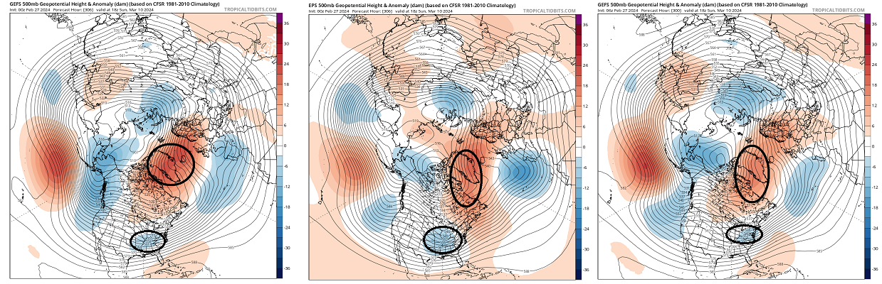
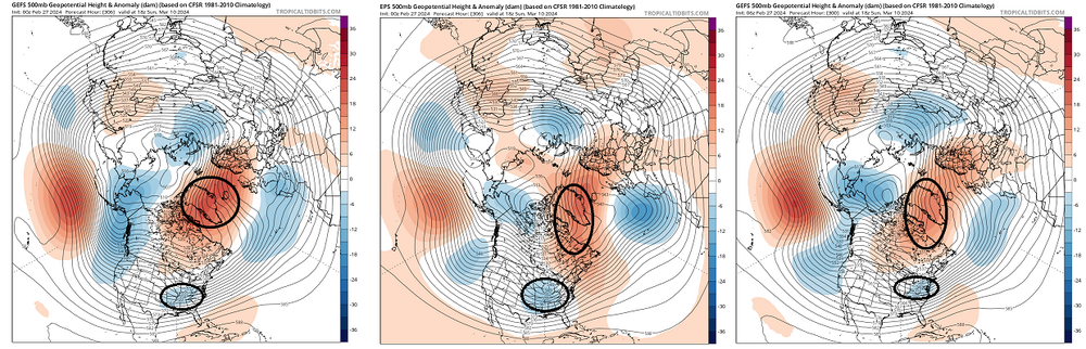
Wow, that's an ugly mid month for those into early diagnostics ... lot of moving parts to consider. At a step back perspective, there's a clear climate precedence for post early warm episodes, to see the materialization of a -NAO. When looking at the overnight layouts from all three majors .. there's hints of that taking place, so seeing as it matches said climate precedence ... The first most obvious detraction about this outlook would be the D12 distance ... It's really beyond the "confidence horizon" at that range. However ( again ), the historical inference: said outlook fits the motif of mild to warm (relative to season, and by pattern recognition) in the foreground, evolving into -NAO. So we wait. That trough I annotated slipping underneath is of Pacific origin. It's been gaining coherence ... despite the long range. This complicates matters ... if a more aggressive emergence of the NAO transpires ( which I believe is well within the 'realistic' probability envelope ), it could either evolve into a suppressive influence ... or something more ideal where it loads cold into Ontario but doesn't interfere ( negatively) with the wave space as it is forced S of our latitude. This latter scenario sets the stage for ... The sun, working into an 'elastically taut' hemisphere aching for a reason to normalize gradients because of normal seasonal forcing, together with back ground ... this whole evolution above is going to be getting whacked around a bit in future guidance.
-
Occasional Thoughts on Climate Change
Typhoon Tip replied to donsutherland1's topic in Climate Change
Kinda of ... ? I don't think capitalism and "price regulatory aspects" need to be mutually exclusive. "Capitalism" isn't the problem. - doing so unconstrained, thinking it is alright ( or just being oblivious, sociopathic ...etc) to be unencumbered by moral responsibility to the consequences of an unrestrained system? That's where the problem is. Capitalism is a human invention - we decide. In a very coarse definition, we could say free and fair economic system that is within the confines of moral responsibility - chiefly, to do otherwise and undermine the ability to survive, violates the fundamental principle of being alive, which is to protect the ability to be alive. What I was saying before is that ... humanity is still not connecting CC with a a threat to that level. Ever hear it said in literature and cinema, "I never quite understood. I knew what it meant, but only now I really get it" - this spiritual awakening to the crisis has not been enlightened yet. The CC storm is coming ... When the NHC statement warns, "...Preparations need to be rushed to completion... " That's where we fail to connect. It may be an untenable at this point. The "system" is gotten to be 'too big to succeed', ironically. -
Today is a extreme diurnal range watch ... Low bottomed out at 26 here .... feel pretty good about a run at 62 which would exceeds 30 Looking upstream, zip appreciable cloud through which the region is now receiving season changing sun. MAV is 58-ish. It'll be a nerd's joy testing that -