Typhoon Tip
-
Posts
44,833 -
Joined
-
Last visited
Content Type
Profiles
Blogs
Forums
American Weather
Media Demo
Store
Gallery
Everything posted by Typhoon Tip
-
Blowvember - and not named for wind potential
Typhoon Tip replied to Go Kart Mozart's topic in New England
it was directed at kevin, because he attempted to spin what i said into a false impression/implication - and the twaddle that is out on social media that is consummately revealed by the trump supporter constituency as though it were fact, is preposterous dude. sorry, it is - as far as the other, america made a mistake - that can happen. and by the way... global warming is real, and it will cost humanity in increasing morality and destruction. it is so real in fact, that many present day natural disasters can be mathematically ( you are school teacher - you should understand the incontrovertible aspect of math proof ) connected to wildly changing climate. -
Blowvember - and not named for wind potential
Typhoon Tip replied to Go Kart Mozart's topic in New England
i know what you mean .. but just sayn' the "pattern" is highly likely to change. it may be transient and short lived... but, that is about as high on a statistical chi test for verification potential as is physically possible in modern technology with that west -nao block and deep trough running underneath. it's a matter of ironing out the details. see ... some times, you can be more certain about a mid or even extended range look. this thing we're looking at with the north american set up was sniffed out 12 days ago actually, by pure index interpretation alone - i know.. i wrote about it. and well, ... here we are, the operational runs emerged into that correlation. that behavior alone is typically a higher confidence predictor. etc... it's when we're flying along with nothing to look at and no leading indicators, and then all the sudden ... d9 has a bomb that lasts for 3 days of guidance - but uh uh uh ... d5 it disappears. that was never a higher confidence - ... there's all kinds of examples in either direction. the good fellas know which ones are which -
Blowvember - and not named for wind potential
Typhoon Tip replied to Go Kart Mozart's topic in New England
i think his intentions are buckin' for 'saving' his dystopian drought fantasy - not snow this time... lol -
Blowvember - and not named for wind potential
Typhoon Tip replied to Go Kart Mozart's topic in New England
it's been rarefying, sure tho. correction to what Kevin just said... I did not 'make a call' for a 'big nor'easter' - i made a generic implication interpretation of where those particular ensemble means appear to be trending. this is how the trump supporters create their fake realities and then believe in them. someone prevaricates an interpretation, ...then, their audience, being of cutting edge sharp intellectual pedigree rural red origin as they are ... they go ahead and 'analyze' what's said and shockingly, can't come up with any reason to question it. budda boom budda bing ... alternative reality is painted and the hapless contingent of morons are thusly guidance by an illusion -
Blowvember - and not named for wind potential
Typhoon Tip replied to Go Kart Mozart's topic in New England
fwiw .. .the 12z gefs and cmc ens means are significantly more deep with that closing southern component rex configuration next week ... this looks like it's trying to head toward a triple point nor'easter that abandons an old inland center type synoptic evolution.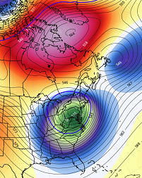
-
Blowvember - and not named for wind potential
Typhoon Tip replied to Go Kart Mozart's topic in New England
it'll be interesting watching these operational models engineer nothing out of a +pna/-nao loading pattern going forward. but, can't say this wasn't suspected. i spent more time than i should writing about the all but dependable cold loss in guidance, when moving patterns from the ext into mid range just the other day. also, those upside-down lows, with snow on the under belly in drilling west wind, and warm ( relatively so...) rains wrapped around the n side ( 120 hours) will tend to really go one way or the other. that's an unusual/rare verification as is. my guess in this case it goes to just rain. this is a -2, western limbed -nao with under running +pnap, after novie 15 ... where's the cold air. -
seems unlikely to me that a wpo/epo mean < 0 ...even if only between 0 and -1, would lend to that temperature distribution, at least along the np-lakes-ne belt but maybe some cc urine in the punch
-
Blowvember - and not named for wind potential
Typhoon Tip replied to Go Kart Mozart's topic in New England
that thing goes from ~ 990 mb to 960 mb in 10 hours lol challenges believability a little but we'll see -
Blowvember - and not named for wind potential
Typhoon Tip replied to Go Kart Mozart's topic in New England
yeah and who knows. but it's e of the others. i'd also note that the others are trending east - just not as aggressively. ex, the ggem was over michigan wednesday's 12z -
Blowvember - and not named for wind potential
Typhoon Tip replied to Go Kart Mozart's topic in New England
fwiw - the ggem is east. just sayn' -
Blowvember - and not named for wind potential
Typhoon Tip replied to Go Kart Mozart's topic in New England
something similar happened in jan 1994 after that decent late dec to mid jan winter expression suffered a cutter and we soared to 62 f by 9pm ( 9 at dawn with snow grains earlier that day, i shit you nae ) with tree leaning white noise turbine gusts. there was steam rollin' off the snow banks. i saw the same thing then, too there's thaws. then there's fire-hose thaws - -
Blowvember - and not named for wind potential
Typhoon Tip replied to Go Kart Mozart's topic in New England
the gfs is doing something suggestive of the back ground forcing here. the -nao is western limb in the physical exertion - you can coherently see the +2 sd block over baffin island/vicinity up there... but that places the best telecon for coupled nadir between the del marva and ns/canada. meanwhile, the archembaultian amplitude *there's a concurrent +d(pna) going on* is coring out a deep dawg over pa. that can happen buut, it is in fact stressed - the better correlation is farther e with that. it may be seasonal/wave spacing, where this early in the season ... shorter distances causing more meridian flow so things close off early. interesting that the ggem is spot on the correlation tho - anyway, the gfs seems to respond to the back ground governing kinematics by attempting a new deepening se of cape code as that whole mess rotates through. the homage to the back ground forcing is more telling than the actual depiction throughout - in other words ... possibly signaling the direction of the correction vector -
Blowvember - and not named for wind potential
Typhoon Tip replied to Go Kart Mozart's topic in New England
i don't recall that one. huh - i was up at uml, probably heads down on how what was clearly going to be a historic front loader was going to effect us here in eastern sne, being why-for the distraction. but i do recall a steady diet of nickling threats kicking in early-ish in novie, then not seeing bear ground until the thaw of late jan, '96 -
Blowvember - and not named for wind potential
Typhoon Tip replied to Go Kart Mozart's topic in New England
yeah... it's trend continuance actually. there's been a tendency among all guidance ( for that matter ... ) for this pattern change-leading h.a. system to punch east of previous guidance. this one has a deep pva generate height response e of cape may nj at this point - furthest e yet. if it were not for the others also doing some of this east trend, i would roll eyes at the source but - again, lacking cold air... but that solution is like the canonical autumn page turning nor'easter of olden days. we used to depend on one block buster in autumn that was cold rain ... and one in late march that's wet/blue snow -
Blowvember - and not named for wind potential
Typhoon Tip replied to Go Kart Mozart's topic in New England
pretty fat recovery today too. big diurnal swing. 21 at 4 am and now 54 type rise at these home stations within a mile of me... but this spread matches kfit identically zip wind ...even the sloped sun of solar min is offering some nape affect out there. -
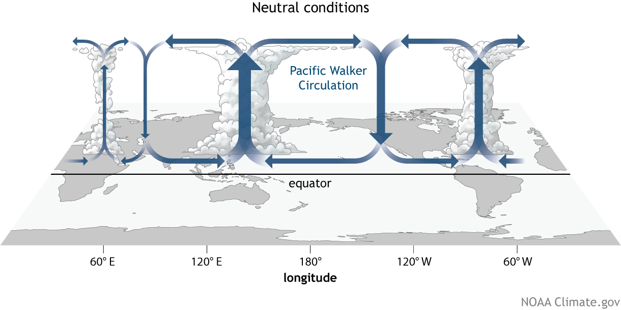
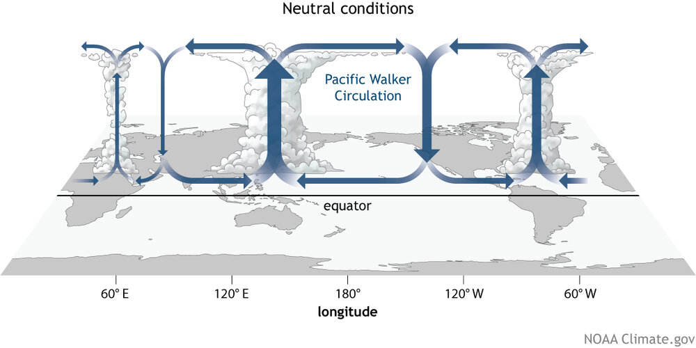
are we looking at mjo or we looking at a result of the walker circulation - for the gen reader, mjo doesn't present much more than 20 deg of lat n/s of the equator. it's the wave dispersion kinematics, spread out over the larger manifold beyond that latitude range, down stream ... which means by that physical definition, it is indirectly modulating as a forcer. it's also high subjected to constructive versus destructive wave interference in the rossby scale. that's why some mjo phases appear to correlate to pattern ( lag ), where other do not ..despite similar magnitudes. also, we bear in mind that the mjo can straddle one side of the equator more so than the other. some stronger wave/rmm prognostics could in fact be registered in the southern/northern side, respectively. there's a lot to consider there in the total machinery of the mjo ... and that look on those panels there appear to reflect more of the in situ walker signal.
-
Blowvember - and not named for wind potential
Typhoon Tip replied to Go Kart Mozart's topic in New England
this was 'fake cold' though. these last two days... even the day times held to 40 were kind of fake, too. "fake" semantics, that's probably a rubric for any situation were hot or cold over performs, relative to broader indicators/standard lens. you look at the charts, and the hydrostatic heights are barely below 550 dm thickness, which is the result of integrating moisture into the non-hydrostatic heights ...? never mind anyway, you don't typically get 20 f lows under 550 thickness. that's more likely to occur under 535 or less in 'standard synoptic' loading. also, keeping the high temperature just 40 f - granted the sun is now beans for heat contribution, still, we've seen 60 at this time of year/sun at 550 dm thickness. basically, the middle range of the troposphere is warm, the surface is cold ...relative to the former metrical layout. by a comparatively slivered range, too. so, we've been faked out. the end of the month isn't fake the way those indices modes are at that time. it's also nice to see the operational runs buying in a bit more. -
Blowvember - and not named for wind potential
Typhoon Tip replied to Go Kart Mozart's topic in New England
it's been a rather remarkably persistent signal, given both time of year, ...and recent decadal propensity for signals of any kind or context to not be persistently dependable. haha. seriously though, thanks giving week's pattern change. ..as an aside, this is just the way i personally get aroused ... nice and early front loading winter signals, hitting on the front side of the solar minimum entry. caveats are still this tendency to correct cold --> warmer, over time ... it's become a rather dependable aspect in all modeling for several years. still not abundantly sure why this occurs. i'd love to blame cc, but i don't really see how that would be the case mathematically - unless the moders really are fiddling with coefficients which according to literature ...there's nothing like that. i dunno. either way, we could verify the hemisphere and do so with less cold complexion. long way to go on that -
Blowvember - and not named for wind potential
Typhoon Tip replied to Go Kart Mozart's topic in New England
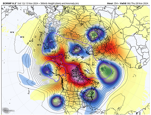
ooz euro and gfs oscillating toward the colder side of the a index range though for beyond the 21st ... i get it that we should go above for a bit in the foreground. however, this isn't like the earlier balloonings to +15+ c 850s over the top of a cc height dome this time. we're only recovering to half that - so it looks at this time. then we'll see if the pattern change is stable in future guidance. still a long ways, but it's impressive to see the weight of the euro and gfs ens means ( both ...) similar on this set up below, which is actually already corrected the 500 mb e enough that given a month and more antecedent cold we'd be talking about a major potential. as is, a slug of cold rain with wrap around hill top frosting. but that's a deep western limb -nao. notice also the -epo formulating over the alaskan sector - watch that for a cold load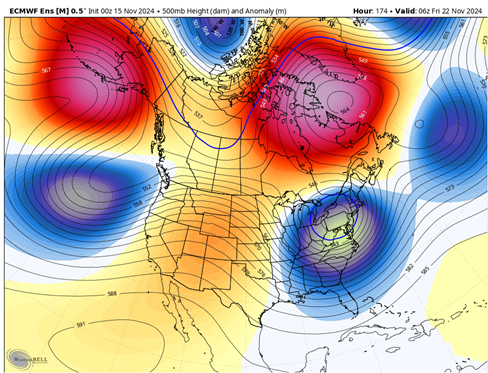
-
Blowvember - and not named for wind potential
Typhoon Tip replied to Go Kart Mozart's topic in New England
agreed .. i mentioned the same yesterday -
Blowvember - and not named for wind potential
Typhoon Tip replied to Go Kart Mozart's topic in New England
Both things are true though … west -NAO/ emerging +PNA arrives while it modulates both less - + , and less cold over time -
Blowvember - and not named for wind potential
Typhoon Tip replied to Go Kart Mozart's topic in New England
that’s a wholesale reversal in the anomaly distribution over eastern n/a between now and d9 in all three main player ensemble means. may and probably will prove transient but it is a coherent pattern change -
Blowvember - and not named for wind potential
Typhoon Tip replied to Go Kart Mozart's topic in New England
it’s something i’m paying attention too, ‘correction behaviors’ going from ext into mid ranges. cold enthusiasts may want to pay attention too … as we age into winter. this weekend’s script got flipped somewhere along the way … almost too subtle to have readily noticed. 3 or 4 days ago it was a cat paw windy showers around a retro low … now it’s 60s on Sunday with dslope dandies are we doing this in winter - are we doing this later this month for that matter. -
well ... for now, let's get the pattern to succeed in moving from the recent warm complexion, to a colder one. that much i'm higher confidence. however, it is still necessary to get the cold synopsis machinery working ... without it, 'what can go wrong' precedes the question - the only cons i see for now ( memo from the 'what can go wrong' department ) is that because the index prognostics are a bit more unstable in the transition seasons, that takes some confidence away. - additionally, in recent decade(s) there has been less stability with telecon predictions - probably owing to increased mid latitude, base-line wind velocities effecting the spatial and spatial-temporal ( both ) wave#s 2015 is really the last time a rossby signature set up and locked. it's sort of been that long... lots of roll-outs/ and pattern changes with shortened lease tendencies, etc.
-
kidding there ... but, the euro - i suspect - will not operate with any restraint in the extended, more so than the other guidance, this cold season. i've just too often in the past looked at that model on d9's and thought ... damn! if only this model went out 2 more days.