

Typhoon Tip
-
Posts
43,342 -
Joined
-
Last visited
Content Type
Profiles
Blogs
Forums
American Weather
Media Demo
Store
Gallery
Everything posted by Typhoon Tip
-
Possible coastal storm centered on Feb 1 2026.
Typhoon Tip replied to Typhoon Tip's topic in New England
Man... haha that 06z ICON was going to be among other greats and GOATs if that were allowed to move out beyond 120 hours. That's a Miller A that gets captured by an N/Stream cutting off trough with a mid and u/a cold air anomally that's that like -5 SD. Jesus Christ! That's like a matter coming into contact with anti-matter. -
Possible coastal storm centered on Feb 1 2026.
Typhoon Tip replied to Typhoon Tip's topic in New England
Yeah there's been some solutions spitting out storms at different dates between the 28th and the 3rd ... Really, the whole period is/was susceptible. However, the recent runs are honing the 1st *(see the dates on the charts being provided). It all would have been the same, really. Uuuusally, though, it's the front side, between the rising inflection and max of the +PNA is when things happen. Then if you are lucky ... it pulses with periodicity such that you get mainenance storms after the fact - but let's not get greedy just yet. haha. The 1st is better situated relative to that and the timing et al. -
Possible coastal storm centered on Feb 1 2026.
Typhoon Tip replied to Typhoon Tip's topic in New England
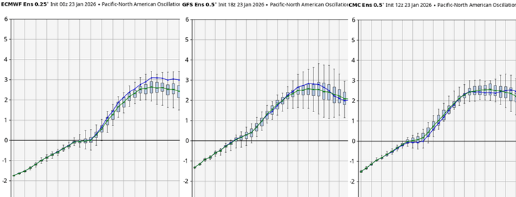
Okay so ... some key synoptic facets. 1 the western end of the modulating SPV 2 the interloping S/Stream injecting underneath 3 the heights over the SW Atl Basin are psuedo relaxed; evidenced by larger gap in isohypses, with balanced geostrophic wind only 30 kts, and heights lower the 582 or Miami ( as proxy). What I'm not showing in this image is the western ridge/+PNA response, because it is yet to happen. In two more days after this 81 hour Euro solution from 06z, the western ridge surges polarward.. right along a very complementary longitude. This helps to trigger the N/stream's descent in latitude through the lakes - that western fragmentation of the SPV. As this happen.. the 3 is not as shearing/destructively interfering as it would be if the heights were higher and the balanced geos. wind was strong...such that the whole structure is allowed to conserve more of it's amplitude as the phasing commences... sex happens... and it all gives birth to a storm.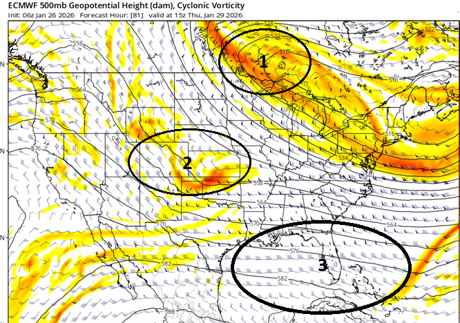
-
Possible coastal storm centered on Feb 1 2026.
Typhoon Tip replied to Typhoon Tip's topic in New England
Ha Ha Ha my company has a ...wait for it! SNOW DAY. -
Possible coastal storm centered on Feb 1 2026.
Typhoon Tip replied to Typhoon Tip's topic in New England
Hard to compare? I realize you're making conjecture and it's all good and fair. But this thing ending today, and that thing in 6 days are apples and oranges in the atmospheric setting and governing kinematics. So favoring has to just be whether it exists or not ... I admittedly lapsed on this most recent one. I discussed this in the storm thread ... But this one appears to also be an index signal if we ( or I - ) had bothered to look. About 10 days ago there was a very coherent MJO phase 6 wave space in the RMM. This has a strong correlation to warmer than normal across the eastern 2/3rd of the middle continent. This timed with typical MJO lag for this same period as the storm... so what gives? Well, the intense -EPO cold load that set up right on top of it. It's really a clash of two disparate implications... the STJ that came across the Baja and went over Texas, was the MJO wave termination mechanics, then encountering a -3 SD arctic invasion. Amazing really... It was all MJO warm/moisture going over top an arctic dome. There really was only weak low pressure... -
Possible coastal storm centered on Feb 1 2026.
Typhoon Tip replied to Typhoon Tip's topic in New England
Yes... one idiosyncrasy as we observe this thing in these early pages ... there is a preponderance of very deep members. That's been a thing with this for the past week's worth of modeling... the variance has been very all or nothing. I find that particular behavior interesting. Either the model in question has nothing ... or something sub-980 bombing. That's red flag as to potential - which we already know is there... but the member variance is typically narrower and closer to a mean that is more middling. Sub 980s are spread NW -
Possible coastal storm centered on Feb 1 2026.
Typhoon Tip replied to Typhoon Tip's topic in New England
Really fundamentally flawless in this 06z operational Euro and it's D6 ... not D9... But again, I'm more confidence established on some kind of system in this window, because as I've been pointing out for well over a week, the indexes have been firing warning shots across the bow the whole time.
-
Possible coastal storm centered on Feb 1 2026.
Typhoon Tip replied to Typhoon Tip's topic in New England
Yeah, I just saw the 06z Euro... primitive albeit impressive attempt at continuity. -
Possible coastal storm centered on Feb 1 2026.
Typhoon Tip replied to Typhoon Tip's topic in New England
lots to sort out but at least for the moment, they all look like pieces of cryo-dystopic candy -
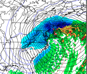
Anomalous upper pattern appears to finally be emerging into well-established and very stable/persistent index signal. This could have been the opener for the arriving February thread, however, I feel this has some statistical significance that is higher than the background climo; it should be isolated at this time when considering these very recent ensemble trends shown below. These are 00z cycle of the Euro/GEFs/GEPs, left to right, centered on 168 hours. Note, the previous cycle were quite vague if qualitatively non-existent compared to these panels. This is a sudden thrust into emergence, of a well-established and persistent multi-sourced index signal. The operation renditions of the evolution of this are little unusual, for the time being... hints there of a 'hook in latter' scenario, where the flow rotates around and any system might appear initially destined to run away out to sea... However, as the deep layer rotates in time, the surface reflection is captured ... moves due N or even NW. This veneer of this Euro suggests something of blizzard from NYC-BOS ... 00z centered on 150 hours. I haven't delved into details though and wouldn't given to this still emerging. I feel this may be a back NW emergence ... like the Boxing Day storm in 2010, but doing so perhaps along different time scales. Lastly, this can be juggernaut. It is more of a subsume model phasing type. This is not an isentropic driven ordeal. It has ceiling potential that much higher in terms of deeper tropospheric structure. The implications/threat spectrum are thus more than just snow totals. This comes with an assortment of wind/tide/snow/problems to infrastructure ... the usual suspects. Subsumers are powerful because when you have a SPV fragmentation biding time, and then as an interloping S/Stream impulse passes underneath, the cold of N and the latency of warmth from the S or directly infused. For muse, the N/Stream pounces S- it's like 'predatory wave behavior' If you put the 500 mb heights into loop, you can see how it comes down and seems to engulf ... giving the allusion of ingesting the S/stream. And then the new total has grown in amplitude and implication.
-
One way or another, the fast atmosphere wins, and claims some hours off this thing
-
12” S/BR 11F
-
January 2026 regional war/obs/disco thread
Typhoon Tip replied to Baroclinic Zone's topic in New England
Damn… I thought you guys were talking about the AI euro That’s the actual euro at 18 Z That would be quite the massive snow for the DC - Philly region on that look right there. That almost looks like it would maybe then dress straight east unless there can be more -NAO south of Nova Scotia. That’s only six days away. And it’s in that index window that I was hitting at over the last 10 days. Yeah the models just don’t seem to really wanna commit to that, though. I almost wonder if the speed of the atmosphere wave traffic being pretty high it’s kind of blinding Cause usually when these indexes flag signal that strongly come Hell or high water or something happens. But I guess with 6 days to play that’s enough time to manifest. We’ll see. -
January 2026 regional war/obs/disco thread
Typhoon Tip replied to Baroclinic Zone's topic in New England
Yeah, I’ve made it no secret that I tend to check out by mid February most years Little hypocrisy because if we’re gonna have an 1888 March bomb or something or 1993 or 1956, whatever obviously I’ll tune back in, but that’s mostly for the meteorological exotic nature of what’s going on. But if it’s just gonna be run-of-the-mill snowing five or 6 inches on April 20 when you can see it in the weather charts that six days later it’s gonna be up to 60° again. I don’t care for that. Another person probably doesn’t feel the same way in here. People croon for it in April. It’s like people! ha ha ha. -
January 2026 regional war/obs/disco thread
Typhoon Tip replied to Baroclinic Zone's topic in New England
Safe really until the 8th … We exit the solar min and enters the solar transition season on that date. But it’s slow at first … the sun feels more noticeably warmer approaching the 20th+ But it will come fast. Just like in the end of July you think you have a lot of summer and you turn around and it’s September 6. that’s why I like my seasons front loaded… Cold and snow loaded if you can early on and then just give it up when the solar transition season start. Same thing in summer with all my heat from May and June…July 20. Altho caveat because golf gets nice in Sept. October November are just boring to me.Don’t get me started about hell on earth, April. If April could ever be a nice month - Obviously these are all pipe dreams though. -
Too much energy expended in the semantics of the "SWFE" when the term never should have been invented in the first place. Meteorology already defines this type of precipitation cause by isentropic lift. That's all it is. SWFE is just overrunning, because the warm air outpaces the retreat of cold air, and thus... is forced over it. The other thing is that it is not that uncommon for isentropic events to morph into coastals. Sometimes there's a lull as the IB moves off, then the coastal gets going. Sometimes the transition is smoother... it's all kind of variant. We'll see what happens tomorrow but it looks on the PP layout like a coastal that is moving too fast to really clip on the way out. So we end up with a cough CCB decay ...
-
S/BR 1/4 mi vis 6F 8"
-
1/3 mi vis 7.25” S at the moment
-
People should put down the models and just like enjoy this?
-
S 4.25” est vis 1/3 mi 5F
-
Same here ... it's 'almost' S+ during a couple different intervals over the last two hours, but it quickly recedes back to a pedestrian S fall rate. Vis est 1/2 mi ... flirting with 1/4 mi when they occurred. Be that as it may, just under 4" here, so as expected ...accumulation is quite efficient in this cold air.
-
S/S+ est vis 1/4 mi 2.75" 6 F
-
Clearly a CF dump axis from PWM to ORH there... The other max is terrain enhancing.. whether that actually happens, notwithstanding
-
Better growth coming down now. Instead of cryo fog-, it's S- with actual discernible aggregates, albeit on the small side
-
I just keep musing tongue-in-cheek over how 6 days ago, we were looking at this continental mauler storm affecitng everywhere but here... Then, 6 days later... while it certainly is affecting a lot of the country, it actually appears to want to max where it was 0, six days ago - squarely right here in SNE that's an interesting model saga


