

Typhoon Tip
-
Posts
43,367 -
Joined
-
Last visited
Content Type
Profiles
Blogs
Forums
American Weather
Media Demo
Store
Gallery
Everything posted by Typhoon Tip
-
May 2024 Discussion - Welcome to Severe Season!!!!
Typhoon Tip replied to weatherwiz's topic in New England
aaahhh... I'm temped to proffer a CC connection there. Not sure we're necessarily going to balance things out with a "span of years" in this case. We can have a summer and/or winter of old, still, but the return rates are stretching. Just my suspicion - -
May 2024 Discussion - Welcome to Severe Season!!!!
Typhoon Tip replied to weatherwiz's topic in New England
I think you're visualizing a synopsis that has been increasingly rarefied over the last 10 or 12 years ... What is becoming more prevalent during summers: early heat of varying but ultimately unremarkable stature, followed a weakness at mid levels ( when not an actual trough) becoming Rossby stuck along 90W. This has been causing stagnated theta-e positive anomalies at llvs, but because of that total wholesale construct, EML expulsion can't get much E of Detroit before deflecting south. Over here on the E side of said axis, 84/78 putrid black mold air stagnatie has has been mid summer favored. Obviously that is not/has not been true at all times - people have to be nuanced in thinking along gradations and tendency - a tendency to do so, increasing... I'm waiting to see if that emerges again. -
May 2024 Discussion - Welcome to Severe Season!!!!
Typhoon Tip replied to weatherwiz's topic in New England
Yeah a lot of this was diurnally assisted. As the suns come up over the realm that halts the radiative cloud top cooling related destabilizing factor- which is elevated instability. That may account for some weakening look to the satellite. Warning's allowed to expire. I have dim sun through vil debris, and rad looks like nothing is getting this far N in Mass. Probably, this all slides off by 1pm looking at translation rate on sat, and then we'll see if we can muster sfc based instability associated with the front. etc... These morning convection things can get in the way of things. -
May 2024 Discussion - Welcome to Severe Season!!!!
Typhoon Tip replied to weatherwiz's topic in New England
Haven't looked at much but knee jerk reaction to radar trends, ... this isn't doing much today N of about Meriden CT. ... even though there is no warm front being analyzed by WPC... the stuff in SE Mass included with the warned cell entering SW CT and extending back W along that axis, smacks as some sort of boundary. It may be theta-e but I'm venturing that idea without looking. In general, sending anvil debris and light rain N of that ~ axis may not end well for them -
May 2024 Discussion - Welcome to Severe Season!!!!
Typhoon Tip replied to weatherwiz's topic in New England
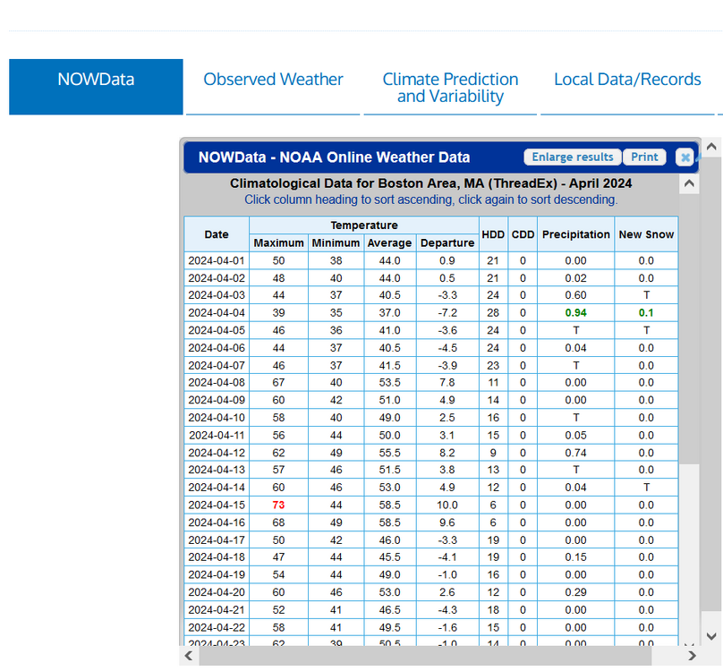
which by the way ... I don't normally access that data source. Did Boston/Logon really trace snow on 3 different occasions last month ? -
May 2024 Discussion - Welcome to Severe Season!!!!
Typhoon Tip replied to weatherwiz's topic in New England
-
May 2024 Discussion - Welcome to Severe Season!!!!
Typhoon Tip replied to weatherwiz's topic in New England
yeah about like yesterday. altho more intense/unadulterated sun on the shoulders adds -
May 2024 Discussion - Welcome to Severe Season!!!!
Typhoon Tip replied to weatherwiz's topic in New England
np here -
I was reading a recent paraphrase republication about the NE Pacific warm pools being a recurring consequence associated with changing circulation modes ( teleconnection). Those that try and correlate these long terms air-sea coupled correlations in winter projections may find this useful ... https://phys.org/news/2024-04-atmospheric-teleconnections-sustain-blobs-northeast.html (the original source material is linked - ) The WPO's influence/factorization in the discussion, notwithstanding, the NE PAC/'EPO' loading is enhanced(ing) these N/A cold outbreaks. Intuitively counter to CC motif as it may be.
-
you know I think it'd be interesting to see this curve back to 1750 ... maybe 1700. 1750 is the widely/historically noted beginning of the IR.
-
May 2024 Discussion - Welcome to Severe Season!!!!
Typhoon Tip replied to weatherwiz's topic in New England
I tell ya ... if we ever get 22.5C at 850 mb in a vertically integrating sounding while this sky condition is happening, we will be 105 at all majors, https://weather.cod.edu/satrad/?parms=subregional-New_England-02-24-0-100-1&checked=map&colorbar=undefined I've noticed over the last 20 years ...when > 22C types of kinetically charged warm slabs, rare as it may be, successfully swath over the region from a SW/Sonoran type heat release synoptics, we seldom observe the above striking purity of clear. We always have poorly timed mid or high level gunk to take the edge off. -
May 2024 Discussion - Welcome to Severe Season!!!!
Typhoon Tip replied to weatherwiz's topic in New England
Interesting ... sort of indirect argument from the MJO desk that lends to the current longer range pattern orientation summer gloom doom by the ens as suspect. I'm just trying to get a feel for the early summer pattern bias - -
May 2024 Discussion - Welcome to Severe Season!!!!
Typhoon Tip replied to weatherwiz's topic in New England
Distant teleconnector projections from all three ensemble system have a dramatic mode change from negative to positive PNA. Nooormally, the PNA takes a backseat in the summer - to which we are not actually/technically in, just yet, granted ( certainly close enough that the PNA statistical correlation should be lowering ). However, that signal is also glaringly and quite unusually massively signaled in the ensemble mean spatial layouts; the depiction of the circulation mode presented imm below tends to rule out the non-correlation argument. In other words, it's difficult to imagine a broad hemispheric foot print like below successfully transporting much AN. They all three look similar to this enough to just use the EPS Deep troughing between Hawaii and California sets up in the deep range, and puts N/A down stream into a set up that looks like it would completely shut down summer as we head deeper into the first week of June. I've seen big signals fall apart this late winter through spring, in the extended range a couple of times. We'll see where this goes as the time arrives, but it does raise some tentative caution flags for the 'unending, unbroken warm season enthusiast' crew, when considering that we've seen more than just 1 or 2 summers end up dimmed after an early warm anomaly period. Just sayn'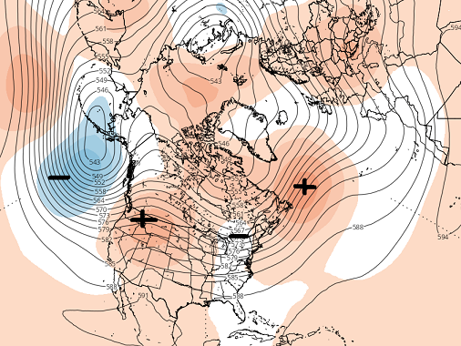
-
May 2024 Discussion - Welcome to Severe Season!!!!
Typhoon Tip replied to weatherwiz's topic in New England
80 here by 9 not bad -
I'm not sure I need to? It's not even in question. We already know
-
Yeah..I get it ( I'm being partly sardonic in my phrase choices here. Ha) no but in all seriousness, there could be a time bomb threshold of toxicity that isn't known... All at once (say) there's a plague of male and female reproductive cancers, or something. Or, being that it's apparently capable of accessing the reproductive cellular exchange barrier... once in there, can it get into one's genetics? In that sense, it's not just potentially harmful to patient zero, maybe it forces a mutation that takes another generation or two to unilaterally manifest - suddenly, all our grand kids are born with half the gray-matter density. With the rate in which recent science has been upending all the previous assumptions over the last 20 to 30 years, what makes any plausibility of foresight less possible? That frequency increase should really inform us that just when we think we know, we only know we don't.
-
Stabilize? it's going to fall
-
Something about the zeitgeist of modernism is doing a psycho-babble job on current breeding aged humanity and that is causing birthing rates to come down, anyway, but the following? It is, at minimum, an indirect implication of purely anthropomorphic pollution over the last 100 years, and is disturbing: https://pubmed.ncbi.nlm.nih.gov/38745431/ Between the two of those, there's likely to be a population sink before the end of this century as time catches up with present heart beats while replacement long fell below 1::1. The implications of which is probably modeled via super computer -reliant mathematical interpolations, or some other sci fi shit ... After all, starting with 8 billion souls, with non-equally distributed testicular numbing based on regional dispersion across the planet, it's not as straight forward. Still, it's easy, given that publication, to imagine a dystopian frame-up where that is part of the cocktail of consequences lending to the Fermian "exit strategy" (tongue in cheek ) It doesn't seem like it takes a complex study to just go ahead and assume at minimum, a population correction has to be the arithmetic fate if fucking isn't producing babies. No need to really write that novel - the stories being written in every breath we takes and food we eat or drink, dumping exotic human innovation into reproductive physiology. That's the "ball" game
-
May 2024 Discussion - Welcome to Severe Season!!!!
Typhoon Tip replied to weatherwiz's topic in New England
That’s more of a fun run from the 18z GFS. thunder chances but remaining warm over the weekend … I don’t mind that. It won’t be raining all the time and there will be cumulonimbus crispies to ogle completely different world compared to what the GFS was thinking three days ago when it had that excessively deep trough… -
May 2024 Discussion - Welcome to Severe Season!!!!
Typhoon Tip replied to weatherwiz's topic in New England
Whereas we never had dewpoint exceed 62 or 63 around here maybe 64. As it were we had highs of 89 or 90 between Fitchburg, Nashua, up to Manchester and New Hampshire. -
Occasional Thoughts on Climate Change
Typhoon Tip replied to donsutherland1's topic in Climate Change
Yeah, thanks. Phys.org is a great site to get the quick and dirty. They do paraphrasing and they always cite the source - they are clean. great minds -
May 2024 Discussion - Welcome to Severe Season!!!!
Typhoon Tip replied to weatherwiz's topic in New England
Anvil wall to my west. Cloudy and hot now... always an interesting very pithy summer vibe when that sets up. 87 Slow moving pulse severes up Rt 2. doubt they get here - have seen this before and they seldom do. Residual showers from dead vils later in the evening with the only thunder being the loud, rapid cricket song. It's also interesting to back up a thunderstorm day anywhere in New England with a heat. This is something I've noted as new to our climate over the last 5 years. I'd always noticed that any convection around here was always immediately rewarded the next day by the complimentary air mass change. In fact it was always so dependable I don't recall it ever not taking place. But this is more than a handful of times now I've seen this taking place over the last several summers now. And it's just May 21. 90 here. Thunder in the area. Even hotter tomorrow. What is this, Enid Oklahoma -
May 2024 Discussion - Welcome to Severe Season!!!!
Typhoon Tip replied to weatherwiz's topic in New England
Ho man... Des Moines could be in deep shit -
May 2024 Discussion - Welcome to Severe Season!!!!
Typhoon Tip replied to weatherwiz's topic in New England
Okay, installation of 2nd floor complete. Schweatty balls doing the task. wow is it hot up there. 84 is the magic temp for this property. If it's 83 outside ... it's borderline up there by 11pm. But 84 ... boom, 1001 degree F I could feel the heat by mid stair well. 90 at several home sites within a mile. Can't wait. In 8 days I getting my estimate for minny splits. -
May 2024 Discussion - Welcome to Severe Season!!!!
Typhoon Tip replied to weatherwiz's topic in New England
well,.. regardless of what is ultimately the high temperature, it's a hot day around this region of N central Mass. Maybe some of that is acclimation but 89/64 yields a HI of 90.x ... so tfwiw FIT and ASH are both 89.6 at Mesowest.utah.edu ... we'll have to see what's up with rounding on that.


