

Kevin Reilly
-
Posts
3,402 -
Joined
-
Last visited
Content Type
Profiles
Blogs
Forums
American Weather
Media Demo
Store
Gallery
Everything posted by Kevin Reilly
-

2024 Atlantic Hurricane Season
Kevin Reilly replied to Stormchaserchuck1's topic in Tropical Headquarters
Explain Sandy then? October 22nd to November 2nd. My avatar by the way is the satellite of Hurricane Sandy. Don't forget about Ophelia as well. It's all about timing and later on tropical systems can be capture or run up along troughs. -
0.58 total rain for last event. 62f humidity 66% dewpoint 52f pressure 29.85 rising Breezy and amazing out open all the windows and the doors and shut the air conditioning off. Low so far today 60f What to look forward to amazing weather through Thursday and the return of the heat by the weekend and early next week. Also, I am sure the tropics wake up next week!
-
Looks like we have the classic split developing here some north and most southwest. All in all partly sunny here 83f humidity 63% dewpoint 69f
-
Event total here 0.58" currently 83f humidity 73% dewpoint 69f temp feels like 90f pressure 29.65 low temp 68f
-
-
We have the orange moon to the southeast and lightning to the west and northwest it's going to be a great night!
-
That is some impressive rain north of New York City Heading northeast slowly. Looks like we have some action too coming in from the west and southwest. Definitely some sort of a boundary NYC to Allentown down to Lancaster.
-
Heavy rain just moved through .26” in like 10 minutes back to sunny again. 73f humidity 94% dew point 72f pressure 29.68 falling high today 88f
-
Light rain thunder picked up 0.09 so far 79f humidity 79% Got Cloudy some peeks of sun light rain and thunder north, but radar lit up south kind of strange.
-
At least you got tomatoes that you can say were the worst you ever seen. We got not one tomato not a one! I only had three plants though. (We had them in buckets not sure that is the way to go??) Early on in late June there was a tomato about the size of a golf ball but it was all brown on the bottom. We did get one green pepper! Currently partly sunny 86f humidity 67% feels like 95f dewpoint 75f pressure 29.71 Rain today: 0.00" Event Total: 0.21"
-
Mostly Cloudy 77f humidity 87% dewpoint 73f pressure 29.78 wind south 6 mph. Plenty of low-level moisture through the peeks of sun. Flood Watch remains. Total Rain so far for this event: 0.21" Looks like we await the cold front to see what becomes of our 1-3" rainfall amounts we shall see.
-
Cloudy 70.2f humidity 92% dewpoint 67 pressure 29.94 Total precipitation: 0.20" last hour
-
Cloudy Temp 72F humidity 77% dewpoint 65 wind south 4 mph. Low last night 71. Rain knocking on the door to our southwest moving northeast.
-
Getting a lot of help evacuating the air upstream with the trough this could aid in some modest strengthening maybe to the tune of 110 mph
-
What this tells me is that the future looks bright for a large ocean storm when it becomes extratropical into the North Atlantic.
-
There is lots of dry stable air poised up here in the Mid Atlantic complete with wildfire smoke from Eastern Canda. Dewpoints in the mid 50's here right now and that air is actually pressing southeast towards Ernesto, so I really think this storm stays in check.
-
The dry air never left its feeding into Ernesto from the Southwest and west. The first signs of trouble was down sloping on the north coast of Hatti as it passed by and now the dry air intrusions continue, I think Ernesto's is probably going to be capped at 100 mph.
-
I arrived home yesterday. I did get a few readings from my rain gauge from my sister-in-law who was here. July 31st to August 13th total rain here in Media was 4.88". Looks like Debby dropped 0.95" or so. Back home and the current weather pattern is opposite of a hurricane strike LOL. We are protected for now. Looks like a North to due South flow. A few isolated showers and dying thunderstorms up north. We have one sea breeze storm toward Ocean County. Otherwise, boring for now. Good Luck anyone who may be in Bermuda.
-
Actually, remember Beryl also was moving very fast as well between 18-25 mph if I recall all the way to the Yucatan.
-
I can't wait to get into some of that. I am currently in Charleston and the low struggled to get to 80f. Driving home tomorrow. Outside of Debby coming through Florida and SC have been on fire! All of the rivers around Charleston are still near record levels down here but are forecasted to drop below major flood stage by Wednesday of this week that is crazy. I guess that is what 10-20" of rain over a large area does.
-
I think today into tomorrow we see some wiggling around on the models that brings this weaker and further west. Almost looks like the system splits into two centers which tells me a weak system or a system with no colocated center. The system may form a center either further west or northwest, but could change the course further down the road. We shall see?
-
I assuming pretty close to what Media got? I’m still not home until August 13th. How about peak wind gusts from Debby?
-
2024 Atlantic Hurricane Season
Kevin Reilly replied to Stormchaserchuck1's topic in Tropical Headquarters
As suggested this morning on the 6z gfs. It’s way too early to say out to sea this early. I mean let’s face it the troughs coming into the east coast if they have made it this whole summer haven’t exactly been strong ask Debby who after a week!!! Has finally got the boot. This is however a typical dance every year along the East Coast so let’s see what happens at this point it’s all about timing and we are far from knowing that at this point and anyone who says they know is just guessing and or using climatology. I mean that below is pretty close. I know one model run but still worth a look.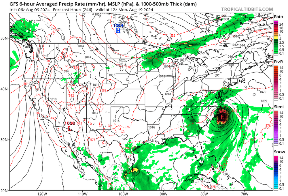
-
Tropical Storm Debby: Mid-Atlantic Impacts
Kevin Reilly replied to WxWatcher007's topic in Mid Atlantic
Very good outflow and ventilation over top! Now future trackers towards the coast it’s a little alarming how far west this got. I would keep the guard up in the next two weeks. -
Awesome map I’m literally on the green area by 8 blocks lol.


