GaWx
-
Posts
18,418 -
Joined
Content Type
Profiles
Blogs
Forums
American Weather
Media Demo
Store
Gallery
Everything posted by GaWx
-
@stadiumwaveaccidentally posted the Oct map as the top map instead of old Nov. Regardless, the CANSIPS old Nov map (regardless of 1981-2010 vs 1991-2020, which was a good catch) was also mainly AN and thus will likely turn out significantly too warm for Nov in the E US once all is said and done due to the cold first half. So, the idea behind the post that the CANSIPS run of last month for Nov will almost certainly end up significantly too warm at least in the E US is a good one. Also, the CANSIPS Oct forecast was too warm in the SE. Based on the persistent EPS forecasts for a weak SPV in Dec, which favors a -AO, I think there’s a pretty good chance that the current (and old) CANSIPS forecasts for a near normal Dec will also end up too warm, but we’ll see.
-
Today’s EPS continues with the idea of a weak SPV by mid Dec with the mean of the members’ 60N mean wind at 10 mb (well up in the strat.) dipping down to only 21 m/s on Dec 16th vs average for that date of 35 m/s. The % of members with a major or impending major SSW during early to mid Dec is similar to yesterday’s of 18%. Longterm climo based chances of a major SSW at any point in Dec is only ~10%. So, this means that the chance for a major SSW next month is per the EPS well above the normal chance even though it still isn’t likely as of now. Regardless, a weak SPV favors a -AO. Edit: ~85% of the 101 members are below the normal of 35 m/s at the end of the run, which is 12/16/23. This all means that the signal for a weak SPV is probably just about as strong as you’ll ever see at day 45 keeping in mind that ensemble means have a tendency to revert closer to climo the further out they go. In other words, it would be virtually impossible for day 45 to have 100% of members below climo. Getting 85% to do that is very hard to do unless there’s an unusually strong signal.
-
Indeed, 2009-10 was the last El Niño with a sub -0.25 DJF (my def of -NAO). Before that, you have to go all of the way back to the El Nino of 1986-7! And then the two prior to 1986-7 didn’t. So, only two of the last 14 El Niño winters (14%) have had a -NAO with only 1 of the last 14 El Niño (7%) winters having sub -1 (2009-10). But before that, 8 of the prior 11 El Niño winters (73%) (covering 1977-8 back to 1951-2) did have a -NAO including 3 (27%) that had sub -1 NAOs (1976-7, 1968-9, 1963-4). So, only 2 of the last 14 El Niño winters but 8 of the prior 11. Is this due largely to CC? At the same time, summer -NAOs have increased in frequency since 2007 as @bluewavehas posted about: 12 of the last 17 summers (71%) have had a sub -0.25 NAO with 8 of the last 17 summers (47%) having had a very strong sub -1 NAO! Prior to that (2006 back to 1950), only 17 of 57 (30%) had a sub -0.25 NAO summer and a mere 4 of 57 (7%) had a sub -1 NAO summer! CC? https://www.cpc.ncep.noaa.gov/products/precip/CWlink/pna/norm.nao.monthly.b5001.current.ascii.table
-
It looks to me like the winter will be a cross between an EP and CP El Niño. As we know, CP are usually the more desirable winters in the E US. And too far west can bring in too much MJO phase 6. Also, I will point out that the frigid 1976-7 was an EP and the very cold 1969-70 was a near EP. So, it isn’t anywhere close to black and white.
-
Looking at the three non-cold non-strong +IOD autumn El Niño winters 1994-5, 2006-7, and 2018-9, all had a +NAO and either a +AO or neutral AO vs the -AO/-NAO of 1963-4. A neutral or -NAO/-AO would probably make a big difference. Regarding -AO, today’s Euro Weeklies weaken the SPV even more in Dec than yesterday’s with an ensemble mean 60N 10 mb wind dipping way down to 23 m/s (vs 34 m/s normal for mid Dec). To show this that far out in time is quite notable. The % of members with a Dec major SSW rose from yesterdays ~10% to today’s ~18%:
-
Thanks. But it has still been struggling to rise big picture-wise. Same with OHC. At one point in late August, 3.4 OISST was over +1.6. Let’s see what happens now. It is a notably strong El Niño no doubt, regardless.
-
On that note of the +IOD El Niño autumns, 1963-4, 1994-5, 2006-7, and 2018-9 weren’t super-strong. Of those in E US: 1963-4 was a cold winter though 1994-5 and 2018/9 were mild. 2006-7 was near normal.
-
He should have also included 1994 and 2006 per this IOD/DMI link and even based on looking at his chart: https://psl.noaa.gov/gcos_wgsp/Timeseries/Data/dmi.had.long.data As I’ve said, I as a cold preferrer don’t like what I’ve recently learned about IOD/DMI and thus hope 2023-4 is colder than most of the winters following +IOD autumn El Niños. I have hope because there clearly are mixed signals. Plus 1963-4 was very cold. Regardless, I’ll be rooting for -IOD or neutral IOD in future El Niños.
-
ASO ended up at -10.45. Since 1950 prior to 2023, this is how ASO SOI came out for El Niños: - The five super-strong averaged -16 (range -11 to -21). - The four strong ones averaged -8 (range -5 to -12). - The six moderate averaged -7 with a range of -1 to -12. - The 10 weak ones also averaged -7 (with a range of +1 to -12). - Thus, this came in weaker than the super-strong range but within the upper part of the strong range for ASO. https://www.longpaddock.qld.gov.au/soi/
-
Latest models are pretty unimpressive. That includes the 12Z UKMET, which has no TCG.
-
The latest daily WCS PDO fell back some more to -0.90 (for Oct 30th). Per WCS, the PDO will come in near -1.0 for Oct vs ~-2.0 for Sep. Since NOAA has been coming in significantly more negative, that tells me that the NOAA PDO for Oct will probably come in or near the -1.5 to -1.8 range, which would be an impressive rise from the -2.94 of Sept as it would be one of the largest El Niño rises Sep to Oct. (rise likely to be in/near range of 1.14 to 1.44): Other large El Niño Sep to Oct NOAA PDO rises: -1876: 1.08 -1880: 1.79 -1918: 0.90 -1969: 2.02 -1986: 1.03 -2006: 1.08
-
The new EPS mean maintains after the stronger than avg Nov SPV a drop to a significantly weaker than normal SPV by mid Dec. with a mean of 25 mps (56 mph) vs climo norm of 34 mps (76 mph) for then (normals peak then). The individual members imply a 10% chance for a major SSW in mid Dec., which is significantly higher than normal as the chance for the entire month is only ~10% and is pretty high for this far out. So, that will be something to monitor. If there were to be no SSW, which is the most likely scenario, this does still imply a good chance for a -AO dominating mid to late Dec. and would put any E US mild Dec forecasts in jeopardy. Keep in mind my earlier post that shows that the extended Euro Weeklies have done much better with the easier to predict polar stratosphere than the polar troposphere because there’s little atmospheric chaos way up at strat levels:
-
I can’t assess personally how the Euro Weeklies have done in general because I just started following their SPV forecasts last Feb. and I only restarted following them ~two weeks ago. They did do well last Feb. Here’s the oldest one I saved (2/6/23), which forecasted the mid Feb major SSW impressively well along with the SPV remaining quite weak into March instead of recovering much: The following graph of Feb 10th forecasts during 2003-22 for 60-90N suggests that the extended portion of the Euro Weeklies likely does much better with the stratosphere vs the troposphere. Note the 60%+ performance (two darkest greens) for above 100 mb (the stratosphere) through the entire six weeks of Weeklies vs significantly worse performance in the mid to lower troposphere (250 mb and lower levels). The explanation is that the strat is easier to predict because of it being so far above the surface, where there isn’t nearly as much atmospheric chaos: Thus, the recent EPS forecasts for a weaker than avg SPV in mid Dec should probably not be dismissed as mere extreme speculation. If we are actually able to get a solid -AO in Dec, then that obviously would increase the chance that the forecasts calling for a mild E US Dec would be out to lunch. I’d be a bit nervous right now if I had a mild E US Dec. Regarding El Niño Decembers since 1950, these 8 had a -AO: 1958, 1963, 1968, 1969, 1976, 1987, 2002, and 2009. So, about 1/3 of them had a -AO (near climo % chance for all Decembers). Which of these 8 were cool to cold in the bulk of the E US? All but 1987, which was slightly AN. Explanation: its -AO was only weak (weakest of the 8) and it was the only one of the 8 without a -NAO (it was weakly +NAO).
-
The extended Euro ensemble has consistently for many days been forecasting a stronger than average strength SPV in Nov (peaking Nov 11th in near record high territory) followed by a weakening SPV to near neutral late in Nov. For the last week or so, it has also been forecasting the weakening to then progress to a significantly below average strength SPV by mid Dec, which implies a good shot at a -AO then along with a better than average potential in mid Dec for an SSW. But keep in mind that sudden SSWs are uncommon in Dec as peak season doesn’t even start til mid Jan. So, this could very well end up as a -AO/weaker than average SPV without an SSW, which would still be a cold signal for the E US especially if a -NAO could somehow accompany it:
-
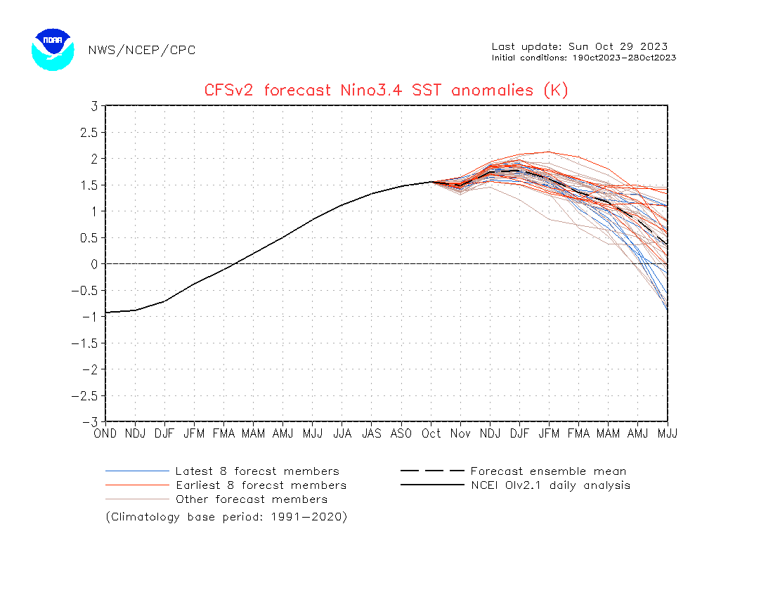
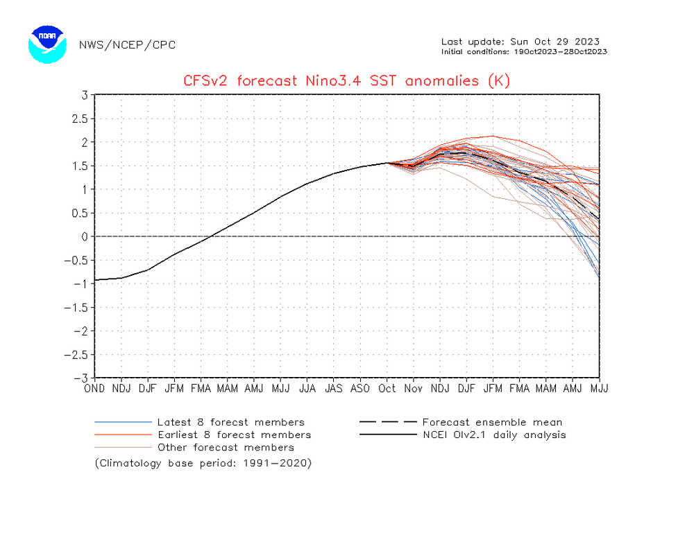
The CFS ONI forecasted peak has been bouncing back recently and is now back up to ~+1.73/+1.75 for NDJ/DJF, vs +1.59/+1.56 in NDJ/DJF as of 10-14+ days ago. The Jan 3.4 forecast is now back up to ~+1.98, which is near its latest forecast for Nino 3. For Jan, it now has 1+2 (which it has been way too cool with for many months) at ~+1.25 and Nino 4 at ~+1.1. So looking strictly at anomalies, the latest CFS has a cross between an EP and CP El Niño this winter. Latest CFS forecast of ONI: peak +1.75 DJF
-
I follow the SAI and it has since 2014 actually been a reverse indicator of the winter AO vs what it used to indicate. So, if the trend of the last 9 years were to continue into the winter of 2023-4, the AO may actually end up negative despite the lower than average SAI so far this month. Also, we still don’t have the final 2023 SAI. I hope it stays below average based on what has occurred since 2014.
-
The OHC anomaly has finally been rewarming recently although only gradually to just over +1.0 C, i.e. nothing to write home about and still well below the mid June and late August peaks:
-
The re-drop on the WCS PDO chart continues and it was at -0.81 yesterday after hitting a high of ~-0.15 on 10/21. The momentum will probably take it down at least to ~-1.00. The drop over the last week is no surprise following the tremendous 20 day rise of 2.45 from way down at -2.60. This is a correction of sorts. What I’ll be watching for is where equilibrium is reached and ends the current drop. Hopefully this won’t be much below -1.00 and it resumes a rise, which is supported by the current strong El Niño. Just a reminder: the NOAA monthlies have been more negative than what these WCS charts have been showing. NOAA daily is probably ~~-1.25 to -1.50 now:
-
So, even more reason to forecast either a neutral NAO or +NAO for this winter overall. (I’m still leaning -NAO in Feb). But what about a -AO this winter? Since 1979-80, we’ve had more -AO winters without a -NAO (9) than -AO/-NAO winters (6). Five of the last 14 El Niño winters have had a -AO (1979-80, 1986-7, 1997-8, 2002-3, 2009-10) vs only two of the last 14 having a -NAO (1986-7, 2009-10). What I feel confident about is a +PNA this winter. A whopping 12 of the last 14 El Niño winters had a +PNA.
-
Based on the last 44 winters, there have been for unknown reason(s) many more -AO (defined as sub -0.50) winters than -NAO (defined as -0.25) winters. These 9 winters had a -AO but no -NAO: 1979-80, 1985-6, 1997-8, 2000-1, 2002-3, 2003-4, 2005-6, 2012-3, 2022-3 At the same time, no winters since 1979-80 have had a -NAO but no -AO. Since 1979-80, there have been 15 -AO winters but only 6-NAO winters. OTOH during 1950-1 through 1978-9 there were 15 -AO winters and 16 -NAO winters. Only two of these winters had a -AO and no -NAO: 1950-1 and 1952-3. And three had a -NAO but no -AO: 1958-9, 1963-4, and 1970-1. So, something has changed over the last 44 years to make it way more difficult to get a -NAO winter than a -AO winter despite an increase in summer -NAOs. So, based on this, I’m giving it a significantly higher chance that 2023-4 will have a -AO vs a -NAO. During the last 44 winters, only these 6 had a -NAO: 1984-5: (NAO -0.70) (moderate La Niña) headed down in cycle 21 with limited sunspots averaging only 20/month; this was 20 months before the minimum of Sept 1986 1986-7: (NAO -0.30) (moderate El Niño) very early in cycle 22 four months after the Sept 86 minimum with very limited sunspots of only 6/month 1995-6: (NAO -0.62) (moderate La Niña) headed down in cycle 22 with limited sunspots of only 12/month nine months before Sept 1996 minimum 2009-10: (NAO -1.67) (strong El Niño) one year into cycle 24 at 13 months after the Dec 2008 minimum just starting to head upward but with still limited sunspots of only 22/month 2010-11: (NAO -0.68) (strong La Niña) two years into cycle 24 at 25 months after the Dec 2008 minimum headed further up but still low at 33/month 2020-1: (NAO -0.42) (moderate La Niña) early into cycle 25 at 13 months after the Dec of 2019 minimum just starting to head up but still with limited sunspots of only 14/month So, there has been no winter of the last 44 with a -NAO averaged out over the winter along with DJF sunspots above 33/month. With us now in an active part of the sunspot cycle, that’s even more reason for me to feel it is going to be a challenge to get a -NAO this coming winter. So, a -AO combined with a neutral NAO or +NAO looks to me more likely this winter than a -AO/-NAO. However, even with that, I’m leaning toward a -NAO Feb.
-
I don’t subscribe. This is from the link posted above. After such a sharp rise, the current decline back to -0.7 from -0.2 is totally expected (reverse dead-cat bounce). What’s not known is how much further this reverse dead-cat will go. Per the current trajectory, it going back below -1 at least for a short period wouldn’t surprise me. Also, the monthly NOAA PDOs have been a good bit more neg than the ones calculated from WCS dailies. If there were a NOAA daily reported, I’d guess it would be ~-1.25 to -1.5. Regardless, Oct will almost certainly come in much less negative than Sep on both. I’m wild guessing ~-1.75 for Oct NOAA vs -2.94 in Sep. That would mean a rise of ~1.19, which is quite significant. We’ll see whether the overall momentum of rising continues into Nov. I’m leaning that way based on the huge rise (on the posted graph) earlier this month along with it being a strong Nino. My hope as a cold preferrer is that we end up with a DJF PDO higher than -1 and preferably higher than -0.75 (I’m talking about how NOAA table measures it). Analogous El Niño SE winters following sharp Sep to Nov rises are 1876-7 (cold), 1880-1 (cool), 1884-5 (cool), 1969-70 (cold), 1986-7 (normal), and 2002-3 (cool). It is important that the rise continues through at least Nov.
-
https://s2s.worldclimateservice.com/climatepanel/
-
It was -.70 yesterday per below though the NOAA PDO runs more negative and is thus likely ~-1.25:
-
I guess it depends on one’s definition of atmospheric coupling.
-
Not only has the SAI not shown a positive correlation to a winter -AO during the last 10 years, it has actually shown a significant negative correlation during that period!