GaWx
-
Posts
19,003 -
Joined
Content Type
Profiles
Blogs
Forums
American Weather
Media Demo
Store
Gallery
Everything posted by GaWx
-
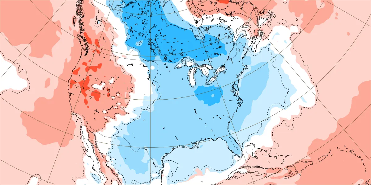
Supporting the above for a -PDO next winter (CFS is similar) (Note that if this verified it wouldn’t at all be E based Niña/closer to Modoki than E based): 2m vs 1981-2010 climo (would be little cooler vs 1991-2020 but keep in mind the cold bias of most models):
-
https://www.cpc.ncep.noaa.gov/data/indices/ersst5.nino.mth.91-20.ascii -What distinguishes 2010-1 was the combo of a record avg -NAO/-AO for DJ for La Niña. -Feb +NAO/+AO ended that -Since 1979-80, there have been only 6 -NAO winters (sub -0.25 avg) with all of them occurring during low sunspot #s (sub 35): 1984-5, 1986-7, 1995-6, 2009-10, 2010-1, 2020-1. To compare, the last 2 winters’ sunspots averaged ~120. AGW is quite possibly a factor in limiting -NAO winters while also increasing their frequency during summer.
-
I’ll believe a legit +PDO is coming next winter when I see it. Posted below is the latest WCS PDO chart showing -0.37 as of March 20. But keep in mind that a -0.37 WCS is comparable to a much more negative NOAA PDO. The Feb 2024 NOAA PDO was still down at -1.33 despite this WCS chart showing every Feb daily being above -0.75 and Feb averaging -0.45 to -0.50: https://www.ncei.noaa.gov/pub/data/cmb/ersst/v5/index/ersst.v5.pdo.dat So, the current NOAA PDO is likely ~~-1.20, still a solid -PDO. Also, the chart below shows that the WCS PDO has been oscillating around this same territory since late Jan (despite how warm most of the E US has been since then). Thus, I still see no indication of a clear move toward a +PDO. For there to be just a weak NOAA based +PDO next winter (say +0.25 to +0.50), the WCS dailies would likely need to rise all of the way to near the +1.00 to +1.25 range. With what appears to be a moderate to strong La Niña coming (probably even stronger on RONI basis as it has averaged a whopping 0.4 cooler than ONI for the last year), that’s highly improbable as of now. The last La Niña winter with a +0.25+ NOAA PDO was way back in 2005-6 (barely with +0.27) and that one was just a low end moderate Niña at most. The subsequent nine Ninas were either -PDO (7 of the 9) or neutral PDO (2016-7 and 2017-8). Prior to 2005-6, the last +PDO Niña was 1995-6 (moderate Niña). Keep in mind that there’s a good chance for a high end moderate to strong Niña (RONI based) next fall/winter. There have been 11 seasons with a sub -1.20 low on a RONI basis since 1949-50, which is very likely where we’re headed next fall/winter. None of those winters had a NOAA based +PDO: 1949-50: -1.6 1955-6: -2.2 1973-4: -1.1 1988-9: -0.9 1998-9: -1.0 1999-0: -1.8 2007-8: -1.3 2010-1: -1.8 2017-8: +0.1 (the only neutral PDO and that was with RONI dip to only -1.25) 2020-1: -0.9 2021-2: -2.3 AVG winter PDO for sub -1.2 RONI: -1.3 Based on the above analysis as well as SSTa progs for next winter that I’ve seen, I’m betting heavily that there will not be a NOAA based +PDO (+0.25+) next winter.
-
Drought monitor map from today (as of 3/19/24): far NW GA dry area gone, but E NC area expanded slightly including in the Fayetteville vicinity. Based on most model runs’ precip progs for the next 10 days (i.e., assuming the 6Z GFS won’t verify), there may be no yellow in NC.
-
After the late week/weekend expected good rains in a decent portion of the SE, mid to late next week also looks wet for much of the SE on most runs of the various models, including ensembles. However, the 6Z GFS was a good bit less wet for mid to late next week than most prior runs. Then again, its own ensemble mean says the op is a dry outlier.
-
1. Yes, that’s a typo on the bottom graph. 2. He actually did well with his cooler revision for 2020-1. My point in showing that though was to show that he’s not held onto a mild forecast for that region since at least 2013-4 due I assume to having a cold bias/warm winter forecasts are bad for business. There are companies that are more objective and will not be afraid to go warm giving them much more credibility. 3. My bad due to poor wording. I don’t know what he forecasted for 2013-4. The only reason I referred to it is that the furthest back ones I can find only go back to 2014-5.
-
Anyone want to bet that Joe Bastardi won’t go 3+ F warmer than normal for the bulk of the Ohio Valley, Mid-Atlantic, and New England for his FINAL winter forecast for 2024-5? I’m not talking about any preliminary forecasts. I actually hope I’m wrong because I’d like to see him do it for a change for his final. I can’t tell you how long it has been since he did just that. One at the very least has to go back to 2013-4 for the final one to possibly be that warm. I actually don’t know what he had for 2013-4 or earlier because I can’t find them. WxBell started ~2010. His preliminary winter forecast for 2020-1 was ~+3 to +4 for the bulk of the Mid-Atlantic and much of the Ohio Valley (New England was +2 to +3): But then he cooled it way down for the final to mainly +0.5 to +1: that’s why I say wait until the final is released
-
Indeed, it looks wet for many areas of the SE late week into the weekend. Also, the latest drought map for the SE overall looks good and way better than it looked 2.5 months ago thanks to El Niño. I know N GA could use a break from recent heavy rains with plentiful creek/river flooding (I saw it) and fortunately it doesn’t look too heavy there. My area (SE GA) has averaged near normal though not too far away in Charleston it has been too wet. This is how bad it was 12/26/23: Fantastic improvement most areas since then with dry area of E NC in line for heavy rain by weekend:
-
No snakes today and a great walk with mid 60s temp and dewpoints near 38 along with a nice NW breeze.
-
Mountain West Discussion- cool season '23-24
GaWx replied to mayjawintastawm's topic in Central/Western States
Cool time lapse of the big mid-March snowstorm in Evergreen, CO, located at 7.2K ft 20 miles WSW of Denver or 10 miles SW of Golden: https://m.facebook.com/WeatherNation/videos/3-days-worth-of-snow-in-24-seconds/732334295379764/ -
Historic Tennessee Valley Cold, Snow, and Ice Events
GaWx replied to Carvers Gap's topic in Tennessee Valley
On this date in 1892 - A winter storm in southwestern and central Tennessee produced 26 inches of snow at Riddleton, and 18.5 inches at Memphis. It was the deepest snow of record for those areas. (David Ludlum) Also on this date in 1892, Nashville got blasted with 17.0” of snow (17" on 3/17)! This was and still is the heaviest calendar day of snowfall on record there by a good margin. And it fell after 4.3” fell the prior two days! Chattanooga got 0.9” on 3/17 and 0.3” on 3/18. Knoxville got 3” though it was recorded on 3/18. Atlanta got 0.3” 3/17-18. -
I’ve taken thousands of walks and until yesterday evening I had never seen three snakes in one walk. I don’t know if I’ve even seen two though I may have once or twice. 99% of the time I see none. So, seeing three yesterday was so ridiculously improbable! Two were poisonous and both apparently were Copperheads of different types. I’d post pics of them here but can’t due to attachment limits. Temperatures were in the 70s while dewpoints were in the 50s. The breeze was light.
-
There are some model hints that the period around 3/23-5 might include interesting wx in a good portion of the SE. Keep in mind that “interesting wx” and “winter storm” are not one and the same even though a winter storm is obviously interesting.
-
The models are near unanimous in showing a sub -20 mean 10 mb (strat.) wind at 60N on March 15th. That would be the 2nd most negative 10 mb wind in March since records started in 1959.
-
March of 1843 was truly amazing! From David Ludlum: Confirmation that the cold and snowy regime of March 1843 was widespread across the Southland came from a new observing post in southwestern Arkansas. In 1840 Nathan D. Smith of Washington; Hempstead County, near Texarkana, commenced a series of very good records which continued at least until the opening of the Civil War. The period from 1840 to 1859 was published in tabular form by the Smithsonian Institution in October 1860, and the record in manuscript is available until April 1861.° March 1843 (35.3°) was the coldest month in Dr. Smith's record save January 1856 (34.0°). His maximum of 70° came on the 30th, the minimum of +6° on the 16th. There were two 4-inch snowstorms, on the 15th and 24th-the same dates that Natchez received a like covering. On another occasion glaze formed on trees, and on another sleet fell.
-
Beautiful dry spring wx is expected again the next two days.
-
I just noticed that the unrounded ONI peak (NDJ) was revised down slightly from +1.97 to +1.95: https://www.cpc.ncep.noaa.gov/data/indices/oni.ascii.txt The RONI peak remained at +1.49 (OND)(border of moderate and strong): https://www.cpc.ncep.noaa.gov/data/indices/RONI.ascii.txt
-
Yesterday was quite nippy here in the ATL area with 50s and 20 mph winds. Today was beautiful and felt much warmer with 60s highs, much lighter winds, and sunshine. It was a great day for walking at the park I was at. The water was high due to last week’s 4-5” of rainfall. I saw several turtles on the lake’s edge.
-
Same with the 18Z GFS it appears. The Euro suites have generally been colder. We’ll see which comes closer.
-
Yesterday’s was the coldest Euro Weeklies map for 3/18-25 since the first one issued. See image below. That doesn’t equate to wintry precip. even if it were to verify. It means a cool period overall would be on the way, including frost and freeze potential. In the meantime a short cool period is on the way prior to then early next week. In addition, the last week of this month has been looking cool on each run though it wouldn’t be as cool per how it is on the run.
-
Most of the ATL area got well over 2” of rainfall for the event ending yesterday and a similar amount is likely for Fri-Sat. Flood watches are already up.
-
I thought this thread and others similar to it are supposed to be for forecast discussion of any aspect of wx that any poster wants to post about rather than being restricted to just discussion of wx a particular member reading the posts wants. Am I mistaken? Anyway, whether or not any particular member wants or cares about potentially the coldest period in 2 months near and just after St. Patrick’s Day, I’m going to continue to post about it, regardless, whenever I have the chance and feel like it. Otherwise, why does this thread even exist? I find many aspects of wx interesting.
-
No change from the above. Ups and downs with a short chill early next week and a potentially longer and colder period starting around St. Patrick’s Day. The St. Patrick’s cold could be intense for mid to late March. Hard freezes in much of the SE wouldn’t be a shock as we will have a very weak SPV through the rest of the month favoring -NAO/-AO and mid to late March El Niños of 1881, 1885, 1906, 1914, 1915, 1926, 1940, and 1983 had hard freezes. This obviously could be overdone but the 12Z Euro (AI) has 850s WAY BN even based on 1981-2010 climo with below 0C well down into FL! Will stupidity become a reality? We could very well see the coldest (in the absolutes, not just in the anomalies) since Jan 21st-22nd! Stay tuned ITT for further updates as they become available.
-
Model consensus is suggesting a short chilly period in one week and a potentially colder period in about two weeks (near/just after St. Patrick’s Day).
-
Keep in mind that if one were to go by RONI or MEI peaks, 2023-4 was a moderate rather than a strong El Niño.