

GaWx
-
Posts
19,135 -
Joined
Content Type
Profiles
Blogs
Forums
American Weather
Media Demo
Store
Gallery
Everything posted by GaWx
-
Today was a near perfect day for a late afternoon walk with low 50s, sunshine, and a light breeze. Todays KSAV high of 56 is 7 BN. The low of 37 is 5 BN. Loving it!
-
Oct-Dec PDO rises of 1.25+ during cold ENSO since 1854: 1878, 1882, 1892, 1894, 1910, 1921, 1924, 1943, 1949, 1962, 2000, 2005, 2007 2024 will likely join these
-
That’s the highest daily WCS since Apr per the chart. Equivalent NOAA likely now down to only -2 from ~~-4 ~Oct 10! MTD ~~-2.5 to -2.8 but rising and could mean full Dec will be ~-2.2 to -2.6 (or ~~-2.4) vs Nov’s -3.24 and Oct’s -3.78. That could mean a top 11-15 Oct-Dec rise (back 170 years).
-
We’re still on pace for a shot at a new record high Dec PNA for non-Nino. Current projections are close to the +1.58 of 2020. Keep in mind that the tabular monthlies tend to be ~1.8 times the mean of the dailies. Current highest tabular Dec +PNA for non-Nino: 2020: +1.58 1960: +1.46 1985: +1.39 2005: +1.38 2000: +1.23 Where were the subsequent Jan tabular PNAs for these non-Nino high +PNA Dec? 2021 +0.19 1961 +1.41 (4th highest on record for non-Nino) 1986 +0.97 (tied for 7th highest on record for non-Nino) 2006 +0.43 2001: +1.51 (3rd highest on record for non-Nino) Avg Jan for these 5: +0.90 So, as @Stormchaserchuck1 was suggesting (actually he was suggesting for all ENSO), +PNA in Dec tends to carryover into Jan for non-Nino. Three of the 5 did strongly and one weakly. The other (2020-1) went to neutral. So, none even went to a weak -PNA. But caution is advised due to the sample size being small.
-
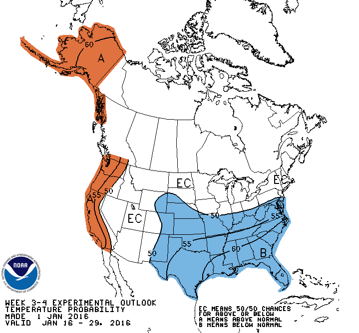
Spot on, Chuck! Last evening I discovered there’s a really good 3-4 week outlook archives section (issued once/wk since 2015-6). For the SE quadrant of the US, yesterday’s is THE most impressive for Jan (I mean based on % chance for BN) on record! It beat out the prior most impressive for Jan, that for 1/16-29/2016, a period that verified well in the SE quadrant with 4-6 BN. It had a major winter storm and flurries as far south as Gainesville, FL!
-
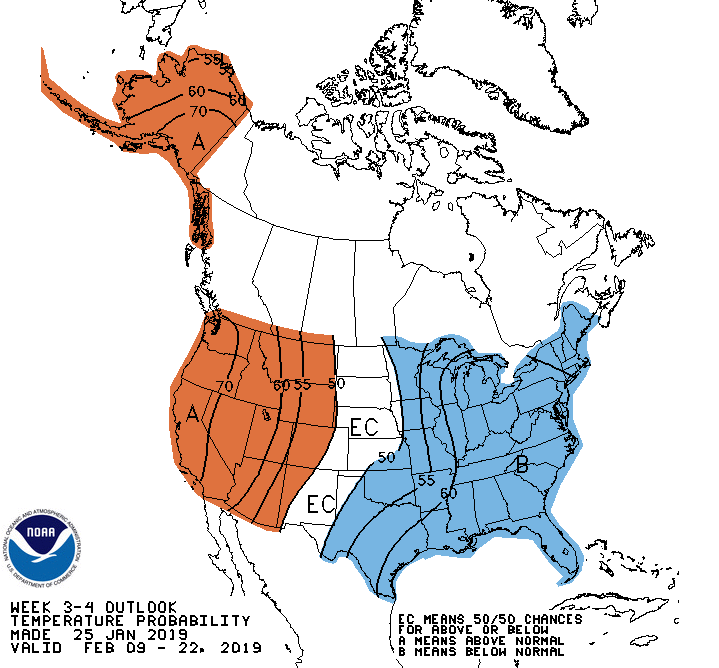
The week 3/4 outlook website has a great archive section. I just took a look at all winter week 3/4 outlooks since they started 2015-6. I can confirm that today’s, with all but the S 1/2 of FL in 60-70% BN chances, is easily THE coldest week 3/4 outlook for the SE as a whole for Jan on record! The 2nd coldest for Jan was issued for Jan 16-29, 2016: 1/16-29/2016 verified very well with the solid cold of 4-6 BN. Also, there was a major winter storm N GA/Carolinas. In addition, flurries fell as far S as Gainesville, FL. (I was there) @pcbjr Could the SE, including Deep South, have a similarly cold and wintry two week period to 1/16-29/2016? Based on today’s coldest week 3/4 forecast on record for Jan, the extended models, Dec cold/strong +PNA analogs, and a decent chance to have an MJO largely near or inside the circle starting on left side, I wouldn’t at all discount this possibility. Could this finally be when the widespread SE major winter storm drought ends?? Was this the coldest week 3/4 outlook on record for the SE for ALL met winter from an absolutes standpoint? There’s only one other that can compare, the one for 2/9-22/2019 (see below). But that one was for a period with avg normals ~3F warmer than those pertaining to today’s week 3/4 outlook. Thus, I’d say today’s is the coldest week 3/4 outlook for the SE on record in terms of implied absolutes being forecasted for all met. winter!
-
For 3-4 weeks out this is quite impressive, especially as regards the 3rd shade of blue, which means 60-70% chance to average BN for a 2 week long period in ~30% of the lower 48. It also has ~2/3 of the lower 48 with a 50%+ chance for BN. You don’t see all of this too often these days to say the least, especially from the fairly conservative NOAA:
-
The Euro Weeklies once again have a strong signal for cold 1/6-12, similar to yesterday. For the 1st time, there’s a tiny bit of the 3rd shade of cold near the OB of NC. If the strong signal persists, future runs should start showing more of this 3rd shade and possibly some of the 4th shade later on. This is getting pretty close to about as strong a signal in this warmer age one will see for a full week of cold 2.5 weeks out on a 100 member ensemble: H5 has an even slightly stronger BN signal with NYC now down even further to a very low 538 dm, which is a whopping 12 dm below the normal of 550! This 538 compares to these the last 8 days starting with yesterday: 539, 541, 543, 543, 545, 547, 547, and 548. So, as we’re getting closer, the signal is getting clearer/intensifying. This is an extremely strong signal for 2.5 weeks out keeping in mind it is the mean of a 100 member ensemble in a warming world:
-
Thanks. I was basing that post on these 3 end of run 2m temp anomalies, which are all significantly colder than prior runs. NG is paying attention and is up another 4% today.
-
12Z model consensus is overall colder late in the runs and is just plain cold! Folks reading many posts in this thread might not realize this.
-
Latest bc MJO of two least inaccurate models are now very close with both into left side of circle early Jan. A good number of past instances of this sort of MJO during non-El Nino have been during cold in E US in Jan (see 7 cases below) GEFS: EPS: Past instances of left inside circle with cold E US in Jan non-El Nino: 2022 2nd half Jan: 2000 late Jan: 1999 early Jan: 1996 1st half Jan: 1994 1st half Jan: 1982 late Jan: 1976 early Jan: But this one failed to be cold: 2023 mid Jan was mild So, 7 were cold and only one wasn’t. But we may have the warm MC to contend with like for the 2023 case although the 2022 case was still cold. And we’ll have to see if the MJO really is going to verify left side inside circle/are these model progs accurate?
-
The multiday averaged CFS ensemble runs have been getting colder in the E US for much of early to mid Jan with a stronger +PNA/-EPO. Most recent individual CFS ensemble runs have had 2-3 weeks straight of BN temp domination in the E US. Euro Weeklies and extended GEFS from yesterday at 0Z agree. Let’s see how this evolves. Will be interesting. NG prices are at new 2024 highs. Newest run for Jan 3-9 (last 3 days of ens runs averaged): Run from one week ago for same period:
-
Strongest cold signal yet with NYC H5 for 1/6-12 down from 541 dm to 539 dm, which is 11 dm BN! That’s now within the 5th shade of blue vs 4th yest and 3rd on prior days. I don’t know if you folks realize how hard that is to do 2.5 weeks out for a full 7 day period on a 100 member ensemble in a warming world! The 2m temps are now the coldest in terms of how widespread they are. They’re still at the 2nd level of BN but I fully expect to start seeing the 3rd level soon assuming the strong signal continues undiminished.
-
Yesterday’s Euro Weeklies: Today’s Euro Weeklies: What does this change from yesterday’s run mean?
-
Latest MJO forecasts from the two best bc: closer together than yesterday as GEFS much closer to circle GEFS bc: EPS bc: colder potential but only if assuming MC convection doesn’t dominate as @bluewaveand my Maxar contact both warn:
-
The extended GEFS have on a good number of runs been suggesting 4-5 Canadian highs plunging down during ~1/3-18 thanks to a dominating W ridge/E trough. The latest 100 member Euro Weeklies mean for Jan 6-12 had a 9 dm BN H5 height at NYC (541 dm vs normal of 550 dm). IF that were to be anywhere close to verifying, that would likely allow for quite a cold week…again IF.
-
But if we could get most of 1/6-17 dominated by BN, there’d still be a good chance for near normal overall even if the SE ridge were strong at the end. If this were to occur after a modestly BN Dec. I’d be quite content as I never had expected Dec-Jan to average near or slightly BN.
-
I’d like to at least get the one cold week consistently suggested by the Euro Weeklies (EW) (Jan 6-12) for a good number of runs. And perhaps 7 or so days averaging modestly BN during ~7 days surrounding that week also sometimes suggested by the EW and extended GEFS. As long as the other 2.5 weeks aren’t too torchy, I’d be content.
-
Somebody in disagreement with what DT responded with this in the comments below: “Eastern based La Niña is better for cold and snow in the eastern U.S not a central based.”
-
DT says central Pacific La Niña is more favorable for E US cold and snow than is E Pacific La Niña. I’m confused @snowman19? Here him say this during very short portion at 5:08-5:30:
-
Folks, the new 0Z GEFS actually looks nice as early as Dec 30th and is the best looking that early in at least 4 days of runs. Progression is really good to see. And the 0Z EPS is a real beaut!
-
The 0Z 12/18 GFS ens extended looks beautiful at H5/H8 along with many Canadian surface highs dropping down during Jan 6-17. Consistent with the Euro. Bring it on!
-
The Euro Weeklies still look nice for cold potential Jan 6-12. H5 is a beaut for a period that’s still 2.5-3.5 weeks out!
-
Today’s Euro Weeklies: Jan 6-12 back to about as cold as 2-3 days ago (a strong cold signal for still being 2.5-3.5 weeks out): H5 anomalies for that week are the most negative of any run. They stick out even more prominently on the world map with the coldest now being the 4th shade of blue (vs 3rd shade on prior runs and vs only 1st shade of blue for most negative in rest of world), which gets NYC down to 9 dm BN/541 dm (vs normal of 550 dm). That’s not easy to do in a warming world for a full week on a 100 member ensemble out 2.5-3.5 weeks: If Jan 6-12 isn’t solidly cold in the E US, I’ll consider it a big bust of the Weeklies. There almost has to be some extremely cold members to achieve this cold of a mean.
-
End of Euro: not as pretty as prior 2


