

jconsor
-
Posts
1,008 -
Joined
-
Last visited
Content Type
Profiles
Blogs
Forums
American Weather
Media Demo
Store
Gallery
Everything posted by jconsor
-
2021 Atlantic Hurricane season
jconsor replied to StormchaserChuck!'s topic in Tropical Headquarters
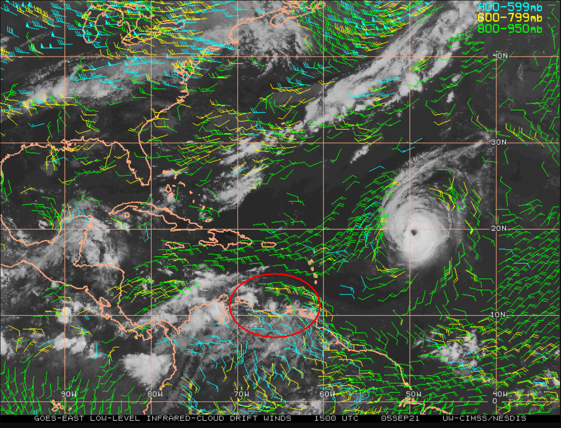
Seems to me that convection is not directly related to what the GFS develops, but just some thunderstorm activity with no real convergence. If you look carefully at the GFS vorticity, it looks like the system the GFS forms in the W. Caribbean is the combination of a tropical wave currently in the SE Caribbean between Curacao and Trinidad, along with a vorticity spoke extending SW from Hurricane Larry. See satellite wind analysis below to see the weak convergence associated with the tropical wave. (As you probably recall, I described the process by which a new tropical cyclone can form from a vorticity spoke extending SW from a recurving TC in this thread:)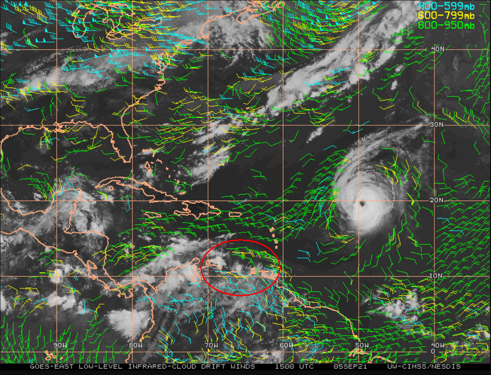
.thumb.gif.efd85fe46a295bc290c6a9d9fab2d86d.gif)
-
Eric Webb calls it quasi-annular, but there are indications that increasing SW shear (shown more by ECMWF than GFS) and SSTs warming to 28.5-29C by tonight and tomorrow may make it hard for Larry to maintain annular status.
-
2021 Atlantic Hurricane season
jconsor replied to StormchaserChuck!'s topic in Tropical Headquarters
This tweet from Dr. Ventrice is strongly misleading IMHO. -
2021 Atlantic Hurricane season
jconsor replied to StormchaserChuck!'s topic in Tropical Headquarters
About potential W Carib/W Gulf system GEFS has been showing late this week into this weekend... -
2021 Atlantic Hurricane season
jconsor replied to StormchaserChuck!'s topic in Tropical Headquarters
Besides the potential GOM system next week, I would watch the western Caribbean late next week into next weekend for development. That area has been a hotspot so far this year for TCs and forecast upper level conditions look favorable. -
-
-
Amounts up to 6" were reported in nw Brooklyn:
- 1,603 replies
-
- 1
-

-
- hurricane gusts
- flooding rains
- (and 2 more)
-
These convective differences between models at initialization/very short-term quickly grow upscale (with time). These discrepancies likely have a significant impact on how strong of a system EPS and GEFS are showing down the road for 95L, in addition to the differences in the operational runs. Note that the models have switched places since yesterday (when tweet from Eric Webb below was written), with GFS now more convectively active while the ECMWF is more anemic. GFS has tended to handle relatively small systems developing in the monsoon trough or ITCZ better than the ECMWF in the past few years- for example, Beryl 2018, Dorian 2019, Gonzalo 2020 and Elsa this year in their genesis phase. https://www.twitter.com/yconsor/status/1426169852050526208 https://www.twitter.com/webberweather/status/1425706495191126021
-
2021 Atlantic Hurricane season
jconsor replied to StormchaserChuck!'s topic in Tropical Headquarters
Look to the western Atlantic and Caribbean for potential development as we approach mid-August. -
2021 Atlantic Hurricane season
jconsor replied to StormchaserChuck!'s topic in Tropical Headquarters
I am skeptical of the EPS idea of rapidly developing the tropical wave currently just off the African coast. Next wave likely has a better chance to develop. -
2021 Atlantic Hurricane season
jconsor replied to StormchaserChuck!'s topic in Tropical Headquarters
@StormchaserChuck! Very impressive subsurface cooling! Have we ever seen -4C at subsurface with surface anomalies still in the neutral range (>-0.5C)? -
2021 Atlantic Hurricane season
jconsor replied to StormchaserChuck!'s topic in Tropical Headquarters
Apropos to William Gray's famous bell that he would ring on Aug 20 marking the rapid uptick in climatological activity... here is a look at how common hurricanes are in the MDR in the first two-thirds of Aug. The short answer - they are surprisingly uncommon and not a good indicator of seasonal activity! -
2021 Atlantic Hurricane season
jconsor replied to StormchaserChuck!'s topic in Tropical Headquarters
-
2021 Atlantic Hurricane season
jconsor replied to StormchaserChuck!'s topic in Tropical Headquarters
-
2021 Atlantic Hurricane season
jconsor replied to StormchaserChuck!'s topic in Tropical Headquarters
Interesting correlation between anomalously warm waters in the western Atlantic (off east coast of the US) early in the hurricane season and East coast landfalls. There also may be a correlation with wet Julys in the coastal plain of the northeast US. -
2021 Atlantic Hurricane season
jconsor replied to StormchaserChuck!'s topic in Tropical Headquarters
I would watch for homegrown development (in GOM or off the coast of eastern US) through the first third of Aug, with limited chance of anything forming in the MDR. Then I would expect MDR activity to begin picking up by around the third week of Aug. However, either type of development would pose higher than usual landfall risks by mid to late Aug based on the projected pattern (similar to the pattern from late Jun to first week of Jul that led to the all-time record heat in the Pacific NW/W. Canada as well as very hot conditions in the ne US). -
2021 Atlantic Hurricane season
jconsor replied to StormchaserChuck!'s topic in Tropical Headquarters
JMA scenario of rising cell in Western Pacific continuing to dominate into mid-Aug is unlikely to verify, in my view. -
2021 Atlantic Hurricane season
jconsor replied to StormchaserChuck!'s topic in Tropical Headquarters
W Pacific TC activity has a significant suppressive influence on favorability for TC activity in the Carib and W. Atlantic, but less influence in the eastern Atlantic. -
SVR-PRE (ELSA) potential NYC subforum Tue-Fri morning July 6-9, 2021
jconsor replied to wdrag's topic in New York City Metro
.gif.3b3f6d42b677e9f8dc181e4b2e9faed8.gif)
