

Buddy1987
-
Posts
3,952 -
Joined
-
Last visited
Content Type
Profiles
Blogs
Forums
American Weather
Media Demo
Store
Gallery
Posts posted by Buddy1987
-
-
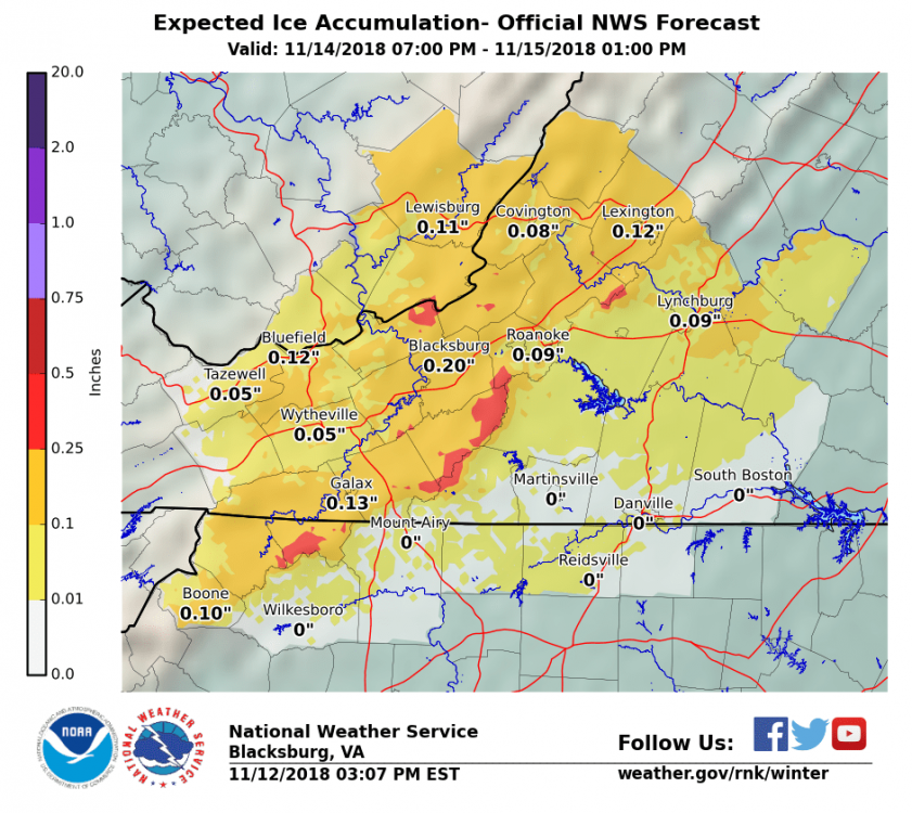
The 12k is DEFINITELY more snowy at the onset at face value for you guys up there. JI is not trolling on that one hahahaha. Raging sleet storm all the way down the rest of the 81 corridor. This is referencing 36 hrs.
@WinterWxLuvr @leesburg 04 And the rest of the crew up in NW VA. This has your name written all over it. 81 corridor never changes over according to the 12k.
-
3 minutes ago, NorthArlington101 said:
Anyone know what the standard ratio for sleet is? RGEM just absolutely whacked parts of Virginia with sleet/ice.
~.75" frozen in Cville but I don't think any of it was snow.
RGEM/12K NAM would be nuts for the 81 corridor in VA. QPF is plentiful with this one no doubting it.
-
To lend credence to the RGEM the 12k nam is actually pretty similar in portraying frozen vs rain. 3k a little warmer during the same timeframe.
-
Ugh I hate my new hours at work. Work until 9p. Please keep me up to date as to what’s happening guys. Crazy to see the RGEM coming in cold again.
-
So if I remember correctly from last winter did the RGEM have a bias toward overdoing low level cold air? Based on the 12z run it would be pretty nuts for the entire area.
-
1 minute ago, Tyler Penland said:
Keep in mind it has a tendency to overdo precip by quite a bit, especially in CAD events right along the escarpment.
Sent from my SM-G960U using Tapatalk
Oh absolutely. I’ve watched these things unfold time in and time out with the nam but even half of that with the temps where they are progged to be has a recipe for a surprise in some areas.
-
1 minute ago, Disc said:
The Blue Ridge south of Roanoke into NW NC are gonna be the "winners" here. Floyd County, VA does ice really well.
What’s your call based off what you’ve seen here ice accretion wise and do you think the CAD is still underplayed? Also does Blacksburg go ahead and issue winter storm watches due to the time of the year with the afternoon package?
-
Just now, Tyler Penland said:
Shows some decent ice accumulation before the changeover though. Still nice to have it washed away.
Sent from my SM-G960U using Tapatalk
Yea especially along the 81 corridor up in VA. 3k nam clown map is just stupid lol trying to signify its intent on laying down some significant ice accretion.
-
2 minutes ago, WxUSAF said:
No. It’s just a downsampled version of the regular NAM. The 3km NAM is the only one to ever look at.
Is there any precursor as to it giving us a clue as to what the 3k nam is going to produce? Just curious because it does have the high a little further west comparing it to 6z as well as popping the low a little sooner in the Carolinas, thus locking in the cold air a little more.
-
Is the 32k nam reliable in peoples opinions here compared to the 12k and 3k? I’m trying to figure out how much stock to put into it when looking at factors for Wed night/Thur such as 2m and 850 temps, etc..
-
Continuing the trends, 6z RGEM is uber cold as precip adverts northward between 45-54hrs. Has freezing rain all the way down the SW NC mountains. I can see the NWS offices are tepid with their forecasts, naturally so as it’s the 13th of NOV but guidance continues to suggest this being a moderate event imo, especially for NOV standards for a lot of the mountain and foothill regions of the area.
-
 1
1
-
-
6 minutes ago, Disc said:
Very conservative after some of these 0z runs.


-
3 minutes ago, WinterWxLuvr said:
My experience is that any situation where CAD is involved the trend is usually colder as it nears.
Wholeheartedly agree. I hope everyone can get something out of this.
-
Lmao! I’ve been Nam’d and GFS’d tonight. Warning type ice accretion on both models down this way and we continue the colder trend up to game time.
-
7 minutes ago, Blue_Ridge_Escarpment said:
Gfs follows suit and comes in colder.
Unreal!! We never flip to plain rain up here verbatim 0z gfs. ZR the entire duration precip falls.
-
14 minutes ago, JoshM said:
FWIW, 3k NAM is having none of this, temps much warmer.
2m dew points are stout all the way into central NC at 60. That will play a factor in this one.
-
I cannot believe we are having a bonafied discussion regarding a winter threat in the middle of November. The 32k nam is bonkers down here in ROA at 60hrs. Absolute perfect positioning of the 1038 HP over Binghamton NY. Timing of precip in my neck of the woods is ideal. Going to be very interesting to say the least.
-
1 minute ago, Blue_Ridge_Escarpment said:
Same here today. High temp of 37 with a low of 31.
The 32k nam is in absolute perfect position at 60 hrs with the HP right around the Binghamton NY area. That imo is where we have our major ice storms due to funneling of the cold air coming straight out of the St Lawrence Valley. As you alluded to as well it strengthened the mb by 2 with a 1038 now being progged. Def a concern at this point. GFS resembles anything remotely close I’d start honking.
-
It’s great to see everyone on here year in and year out! I will say for it being November I was mightily impressed with surface temps today up in Roanoke. Actually got up to 41 and then the column cooled, it sleeted heavily and then turned to rain but stayed around 37 the entire day, even as of right now. I have a sneaky suspicion this one Wed night/Thursday overperforms and def agree with some of the chatter in here regarding Cad setups. Nam will naturally lead on this one so to the newbies pay special attention to HP strength, dew point signatures leading up and onset of precip.
-
1
-
-
The satellite is showing all 4 quadrants beginning to look healthy once again I’m curious to see what this thing looks like when most of us wake up tomorrow morning.
whatever shear was impeding the western and southern portion of the storm has completely stopped now
-
3 minutes ago, DopplerWx said:
some cold cloud tops exploding on the western eyewall now
https://www.tropicaltidbits.com/sat/satlooper.php?region=06L&product=ir
3 minutes ago, SnowGoose69 said:I still am somewhat concerned it could ramp back up. It’s intact enough that if that shear relaxing and dry air abates it could probably get back to a high end 3
Fellas, if it’s me this thing is starting to look very healthy again on the last loop. Deep convection wrapping around and the eye looks much better overall. Nighttime is the opportune time for this thing to get going.
-
7 minutes ago, rjmusser said:
Can anyone help? I'm in a bit of a pickle. Supposed to be flying CLT> ATL > Paris Sat. Leave CLT 11am and leave ATL at 33pm. I am currently trying to cancel my CLT leg and drive down to ATL and leave for ATL on Friday night. Do you think that flight timing would also be in jeopardy? Now with it shifting further south idk if I should stay put in CLT. Not sure on the timing.
Any ideas?
If it were me I def wouldn’t chance trying to get out of CLT. Southwest is looking to cancel flights ahead of the storm and CHS in Charleston is shut down after midnight tonight. I do believe however that ATL flight operations will be good to go still.
My point is as the forecast becomes more evident to verification, airports in Raleigh, Charlotte etc will begin to cease operations. My buddy works for the FAA so he deals with this stuff all the time.
-
7 minutes ago, Suncat said:
Yes, it looks like the model wants the storm to travel against the gulf stream current.
Makes sense. Follow the path of least resistance. I could def see that being a plausible scenario. Would be catastrophic for the entire SC coast. CHS airport closes at midnight tonight.
-
2 minutes ago, NJwx85 said:
Looks like ERC is just about complete. The inner eyewall has diminished. The new eyewall is constricting and deep, intense convection has begun wrapping around the center again.

Some of those cumulonimbi have got to be out of this world, height wise. The convection in the southern and southeastern portion of the cyclone is impressive to say the least.

November 15 Snow/Ice Chance
in Mid Atlantic
Posted
Other big thing on the 3k is it’s only shifted the HP system a couple hundred miles west southwest from 18z. Instead of having it in northeastern VT it now has it around the Syracuse NY area, which is a much better spot for low level funneling. This is at 32hrs I’m referencing.