

Buddy1987
-
Posts
3,952 -
Joined
-
Last visited
Content Type
Profiles
Blogs
Forums
American Weather
Media Demo
Store
Gallery
Posts posted by Buddy1987
-
-
Well... it was fun while it lasted lol. Nam may look worse than 18z.
-
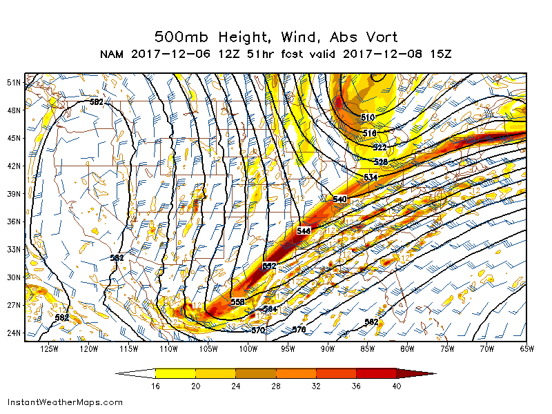
Yea guys unfortunately thus far I see nothing meaningful that would translate back to the 12z run. That was pretty epic. Trough axis is still positively tilted. I’m out to 26
-
Nam run should be initializing soon. The thing that killed us today was that darn bowling ball that drops out of Minnesota. I believe HKY and myself caught this around the 57-66 hr Mark. Keep an eye on that as to how telling the run will be for tonight’s 0z run, along with the orientation of the trough axis. Two indicators if this thing goes the right or wrong way on us.
-
 2
2
-
-
4 minutes ago, Wow said:
21z SREF looks like the 9z from today, which is good since the 15z was a step back. Still not CMC/UKMET level to say the least.
Bring the goods Wow! Talk to me.
-
1 minute ago, HKY_WX said:
Pay attention to that s/w coming due south into Minnesota. They trajectory on that is pretty intense N to S.
My lord. Its like a darn bowling ball dropping down. Much more pronounced then the last view runs of the NAM. Definitely adversely affected precip being able to stream more northward and shunted everything off to the east. Need that pesky thing to get out the way.
-
Still think this is gonna be one heck of a qpf run for someone. The trough axis or the orientation of it is slightly more positively tilted, however it is not that much difference when comparing the 60hr image from the 12z. Much more qpf noted too in MS/AL/GA this run.
Edit: Ahh I see now. The GL low has shifted significantly more southward, thus not allowing for the trough to tilt more neutral. There is a sizable difference noted in that aspect.
-
1
-
-
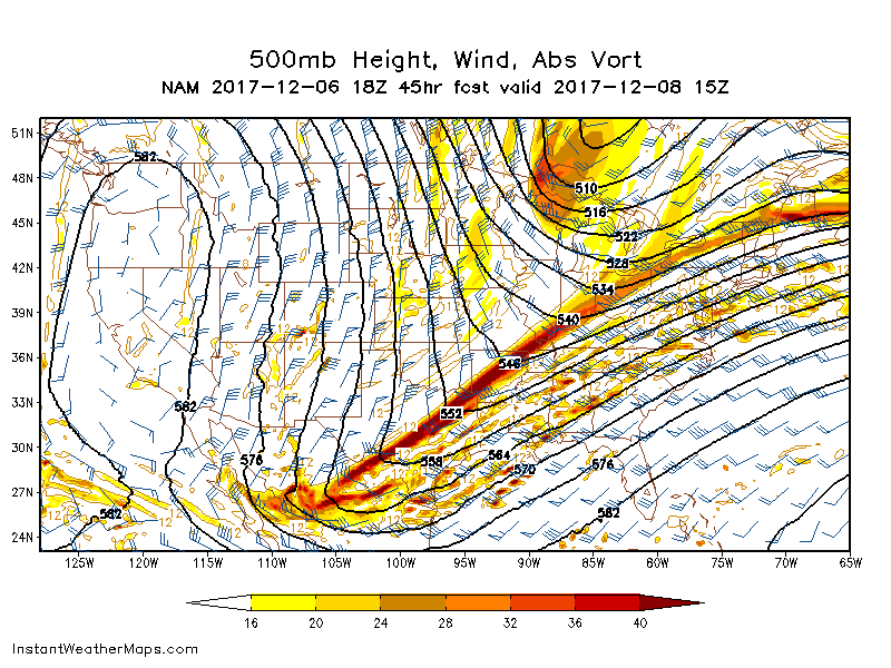
18Z Nam is showing me what I thought it should have looked like at 12z. Pooling of moisture evident over LA,MS and AL.
-
Here is the image I am looking at presently.
-
HR 42 the trough is extremely sharpened once again, albeit it has a slightly positive tilt to it. I still think this ends up somewhat similar to the 12z. Could be wrong though.
-
I just want to know what type of implication the base of the trough has, when comparing hour 33 to 39. How does that affect the tilt down the road in the upcoming frames? It looks even sharper than 12z and holding it back, but yet looks more positively tilted on the northern half.
-
1 minute ago, wncsnow said:
I expect the NAM to back off some from the weenie 12Z run, especially looking at the SREF (usually an indicator of the NAM)
At 25 it is wanting to hold the s/w back over the southwest more. Not sure how that translates down the road here.
-
Just now, SnowGoose69 said:
Through late Friday afternoon it appeared like it was going to possibly came way west but then thereafter that it appeared to be flatter and more east. It was definitely more west for AL/GA on the precip but areas further up the MA region it was more east and drier
Hmm thats interesting. Thanks for the clarification.
-
1 minute ago, SnowGoose69 said:
The new SREF definitely sort of hints what the Euro showed. Things looked better thru 54-57 then it wasn’t as good as the previous run after that especially more north
I am just slightly confused by this. So it is not as amped as last run? Or is the precip coverage better this go around?
-
4 minutes ago, CaryWx said:
The only reason I asked is because Salem and Apex are wicked far from each other in terms of winter climo
When is not a good spot for Salem,Va in SE winter snow forecasting? July??
")
Lolllllllllllll... for some god unknown reason, I had high point in my head. That’s great. Sorry on the confusion!
-
3 minutes ago, CaryWx said:
Buddy, are you in Salem VA??
Yes I am.
-
12 minutes ago, packbacker said:
At 48-60 hours? This should be in its wheelhouse now. I would be surprised if the EPS is much further west and would expect spread to decrease. I also think the snow axis will shift west as the precip will be further west I bet and eastern side wide will be warmer.
I consider you and I, along with the western folks to be in a good spot right now.
-
1
-
-
11 minutes ago, wncsnow said:
Yea, EURO still doesnt look like UKMET or CMC... Its a little bit of a compromise between those 2 and GFS
Snowmap shows Coldrain jackpot over 6 inches lol
I still believe we will see a system leaning toward the more amped versions. This has been an evolving thing the last couple of days, whereas the models are playing catchup with the strength of the trough and with the continuation of moving the GL further north, northeast.
-
Just now, packbacker said:
ColdRain and I can smell the snow on the CMC...we got that going for us. And this isn't even close to being done yet...

The finger of glory! Trough axis perfect to advect moisture for western areas and one could say for the Triad as well.
-
1 minute ago, wncsnow said:
Yea, the GFS looks pretty bad, really thought it would start trending to a stronger system
Ive seen it do this garbage so many times. It stays southeast, and then within 48 hours it will support the camps that are all in general agreement.
Canadian and CMC will be telling. UKIE will be a precursor to the EURO imo.
-
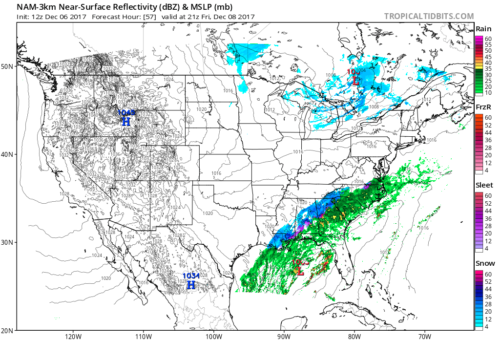
GFS and NAM are night and day at 57. Much more progressive on the side of GFS, with positive tilt almost exclusively the entire time. More keying on the 1st wave noted on the GFS. I really feel like its still on an island in respect to the other models.
-
I think the general theme so far I see out of the 12z gfs is that it too is trying to really sharpen the base of the trough in the same location as the nam did, in and around central OK. May be a sign of caving coming from the model.
-
NAM and GFS through 27 not too far apart from one another at 5h. Trough is a little more positively tilted comparing it to the nam at the same timeframe.
Edit: More noticeable with the positive tilt at 30.
-
1 minute ago, tramadoc said:
Is it a NW trend or is the precipitation field expanding NW? That is the question.
Both. I think future frames will correlate and show with the Gulf wide open the way it is progged that in turn there will be more moisture influx. The tilt of the trough really helps and benefits the trend NW.
-
1
-
-
From Bob Chill in mid atlantic forum: Jan 2000?

The December to Remember 7th-8th blue turd winter threat thread.
in Southeastern States
Posted
I believe the 6z Nam and Gfs may have made me want to look at another run or two before I give in. That’s one hell of a qpf field to my east. Any more trends west and I could be looking at something a little more than I expected.