

Buddy1987
-
Posts
3,952 -
Joined
-
Last visited
Content Type
Profiles
Blogs
Forums
American Weather
Media Demo
Store
Gallery
Posts posted by Buddy1987
-
-
1 minute ago, Blue_Ridge_Escarpment said:
Very interesting. Pretty much like the majority of previous euro runs, just 75 miles north.
You beat me to it brother. All have taken a big step toward the Euro tonight, minus the wonky OP GFS.
-
 1
1
-
-
1 minute ago, FallsLake said:
This will be a case where you want to be as far northeast as possible (it's usually NW). Durham or Wake Forest could get more than Greensboro. Model runs will be interesting today.
Man I’m surprised by NWS Blacksburg on this one. Very conservative thus far and only issuing winter storm watches up this way for the mountains only. Almost every short and long term model I have reviewed this morning shows 6” or more potentially for my area and even to the southwest. Still plenty of time I guess.
-
Never got a chance to report on last nights storm. Ended up with 8” in ROA. Very impressed with last nights and even more impressed for this weekends.
-
2
-
-
6 minutes ago, Northern Foothills Snowman said:
Looking g at radar you are covered in blue. What's the temperature Down to?
We’re sitting at 33 but it is snowing so hard it is just overcoming any type of air above freezing.
-
3 minutes ago, wncsnow said:
Thunder sleet in Danville and 35!
I just picked up an inch of snow in 10 min lolllll. Roads highways everything are destroyed right now and it continues to just pour down like a summertime thunderstorm.
-
1
-
 1
1
-
-
Just now, WeatherHawk said:
Yep, dark dark blue over Salem and my old spot of Fincastle and Natural Bridge
I am literally nerding out. I can’t even tell you how hard it’s snowing right now and the size of the flakes. It looks like it’s raining outside.
-
These dark blue returns over us are LITERALLY INSANEEE!! Just had what looked like a transformer blew outside and a crack of thunder that rocked the whole house. It is snowing the biggest flakes I have ever seen in my life and I have been through some crazy blizzards when I lived in the northeast. Amazingness!!
-
7
-
-
Morning guys. Looks like another good storm up my way here. Most models pivot a band of very heavy snow overhead tonight for SW VA and into Wed morning. Pretty impressive snowfall totals for the area. Will send pics and what not for everyone.
-
3 minutes ago, tavwtby said:
Sun is trying to make it through now...wow two hours ago i was ripping 2"/hr, now it's like a nice spring day..10.5" official report.
Looks like another band of light snow trying to build once again over the hills. Depending on what it does, you could potentially add to the total.
-
Days and days of snow for Downeast Maine. What a radar shot.
-
I am amazed by that band over Windham county. Unreal there the last couple hours. Looking forward to reports out of the county later.
-
5 minutes ago, tavwtby said:
I've tried everything to post pics, sending to myself and resizing, but it's still too large... any suggestions?
Post it to youtube and then copy the link and it'll work. Had the same problem yesterday myself.
@RUNNAWAYICEBERG bro it has got to be dumping over you right now. Nexrad is bright yellow in and around you guys.
-
That band stretching from Lindenhurst Long Island to southeastern Litchfield County, CT looks legitimate. The band stretching from eastern Long Island into southeastern CT has also gained traction and is moving westward at a quicker pace. Gonna be interesting to see where they set up shop for awhile. Meanwhile, to the east of all this looks like complete domination. Unreal snowbands pivoting off the Atlantic.
-
The central CT subsidence looks to be slowly fading away, viewing the wunderground Nexrad radar. The band also looks to be building ever so slightly to the east as well. Should be good times for the CT peeps here shortly.
-
1
-
-
3 minutes ago, RUNNAWAYICEBERG said:
3 but just flurries now while Spanky is sitting under the bandie, he should clean up.
I didn't realize last storm you missed the good band. We ended up with 18'' in Thomaston on that one. Hopefully she pivots or back builds for you in a little.
-
35 minutes ago, USCAPEWEATHERAF said:
Cranky means well, he is just slanted this storm because he guessed wrong, the storm is not moving east, if anything it is slowing down to a crawl currently as modeled way south of the benchmark, bands are already on our doorstep but we have pretty high dew point depressions to overcome before snow starts around 12am, latest GFS all snow, the latest HRRR is all snow to start a little mix with rain at the brunt of the storm passing to our east. This is a cold storm, a cold atmosphere, everywhere I look the 850mb temps are around -6C to -12C, 925mb a little warmer than that, but the boundary layer issues will be overcome in the first few hours of heavy snows, as they occur before sunrise and planting a nice sound foundation of snow on the pavement will offset the warm sun angle non sense in March. Also heavy snowfall rates could exceed 2"/hour maybe eclipse the Blizzard of 2005 in terms of heavy snowfall rates we received on Cape in that blizzard, and longevity of the bands could rival the 2015 Blizzard, in terms of ferocity, this storm will beat out those two any day of the week, with a pressure as low as 962mb in some regards to modeling as it passes east of Chatham, MA we could be looking at feet of snow accumulating over the Cape Cod and Dukes county. Blizzard warning, I think NWS is conservative still, latest 18z GFS had no problems in my estimation, it brought almost 30" of snow to Cape Cod, with the 40-60" max just east of the Outer Cape. Hurricane force wind gust likely 70-80mph is likely on the outer Cape and Nantucket. This is the beast we measure all our snow by, the benchmark storm is coming, I can feel it in the air outside the house, it is rocking from the ENE and the air is cooling rapidly along with moistening rapidly
These are the type of write-ups that make a weather Jimmy a weather Jimmy. I am overly excited to see pics and videos coming out of the Cape come tomorrow. I used to frequent South Yarmouth several times a year when I was younger. The whole Cape is a wonderful place to frequent. You guys are long overdue for a big boy. Good luck out there!
-
LMAO!! 19'' for Kevin on the 18z 3K
-
@RUNNAWAYICEBERG I wouldn't give up on this one yet bro. Could easily see you guys getting 6-8''. That'd be a win in my book. Radar looks sweet southwest of you. We picked up 5'' in VA just from a dying ULL that was the original primary.
-
1 minute ago, CoastalWx said:
Pretty large DGZ and good lift too.
Just when the last storm didn't maybe perform to your standards, you are in line to get crushed with this one.
-
Just now, JC-CT said:
There is some nice banding across the center of CT that run.
You look to be in an awesome spot on this one. You and Kev. What an absolute snow bomb for the Cape. Tremendous QPF out that way.
-
Coming down this morning in western VA.
-
1
-
-
Rooting for you guys once again! Just got home a little while ago here. Winter Storm Warning for us down here. 4-8''. Cannot believe I get in on the ULL and some form of help from the coastal, while the Mid Atlantic gets skipped.
-
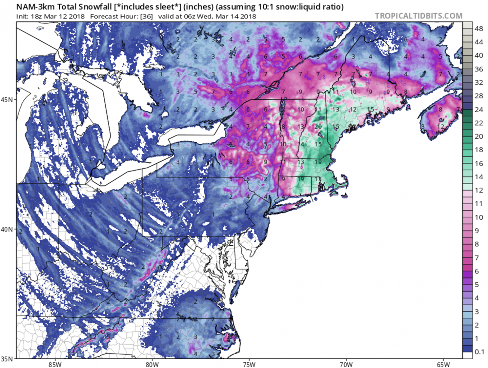
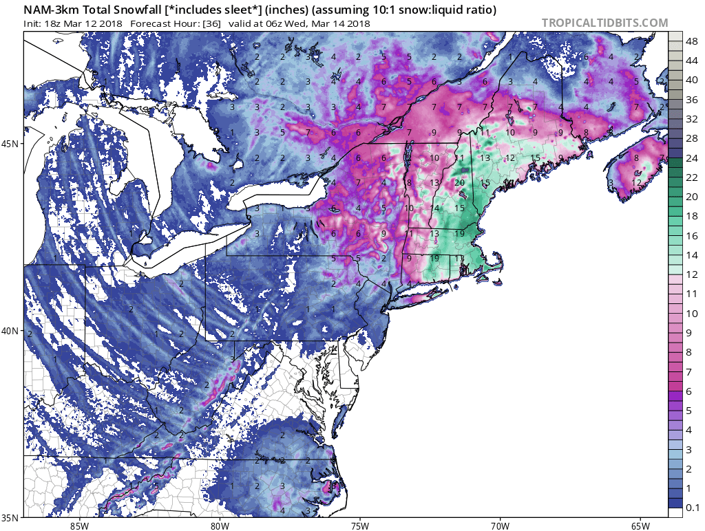
18z 3k Nam and gfs look awesome for southern VA. Looking to reel this storm in. Primary low takes a perfect track for our area for a deform band to pivot through.
-
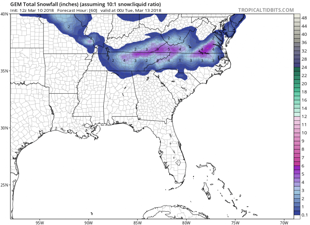
12Z GGEM

Major Hurricane Florence: STORM MODE THREAD
in Tropical Headquarters
Posted
To one of the pros that frequent the board. This is for VA/NC mountains. If the system stalled let’s say over south central SC, wouldn’t that still create a ton of lift and add to a southeast component streaming straight from the Atlantic? Long story short would some of the QPF be under-modeled potentially along the spine of the Blue Ridge?