

Buddy1987
-
Posts
3,952 -
Joined
-
Last visited
Content Type
Profiles
Blogs
Forums
American Weather
Media Demo
Store
Gallery
Posts posted by Buddy1987
-
-
5h is a thing of beauty at 33 on the gfs.
-
Gfs qpf looks extra healthy at 18 already. .25” showing up in foothills/mts of NC and SC
-
Just now, CaryWx said:
Doesn't the NAM have a tendency to overdue precip.?
Yes. That’s why it is somewhat confusing when you have the physics I mentioned above that it wouldn’t paint a better picture than what it is portraying precip wise. A lot of things are coming together and then to throw gulf moisture in there.. I think the 18z gfs did a great job portraying what reality might look like.
-
Just now, wncsnow said:
Think the HiRes Nam has right idea.

I think you have the right idea my man. You have to think we are in the right rear quadrant in this instance, which is going to lead to some pretty decent ascent and lift for moisture to get rung out. Nam is too dry imo at 0z. Not wishcasting but from a physics standpoint the hires Nam is much more “real” looking.
-
 2
2
-
-
Nam absolutely refuses to build the northwestern edge of precip like some of the other models. It is drier this go around for the mountains and foothills. Doesn’t even have anything measurable for sw va.
-
5 minutes ago, franklin NCwx said:
Sref is more amped than the 15z run.
Nam looking to follow already just looking at the layout on 5h at hr 10.
-
10 minutes ago, SnowDeac said:
Always funny watching the S VA folks root for the NW trend that crushes the dreams of 97% of this board. Posts like "epic run of the GFS", just twist the knife.
10 minutes ago, griteater said:I mean, it basically always ends up this way right? Frosty, Jonathon, and Big Frosty sad and moping, saying they can't buy QPF, and they end up with the good stuff.....ha, all in fun Buddy - good luck your way!
I’m sorry guys I don’t mean to be an a-hole. Just very passionate about winter time storms. Huge snow guy. I always root for you guys but if it happens for us I definitely take it.
")
-
3
-
-
GREAT RUN for S VA folks wow!!
-
1
-
-
One of the well respected Mets in the mid atlantic forum, MillvilleWX: "The better jet alignment over the NE will probably lead to another 40-50 mile shift in the overall QPF shield. I’ll let it play out, but if you want a better expansion of precip on the NW side, this is exactly what you want to see. Atmosphere is slowed a touch with the more amplified look East of the Rockies."
-
2
-
-
1 minute ago, Wow said:
NAM slower but juiced up!
Looking at the setup at 5H, I always look for the trough to be over north central Arkansas for the big dogs for the foothills and southern VA and that is exactly what it is showing right now. I really expect a good presentation on the 850 maps upcoming.
-
I think a big run is coming from the NAM looking at 24hr panel. Much higher qpf totals into northern AL/MS.
-
NAM at 18 already tilting moreso to the northwest once again. I look for increased qpf along the western side once again as the frames advance.
-
1
-
-
1 minute ago, packfan98 said:

Very nice Pack. Tucked right in off Hatteras. Mountains will do well just by looking at this 5h map.
-
Anyone on the foreign models for 12z?
-
1 minute ago, wncsnow said:
EURO will be interesting, really wish this weak ridge would go away and the cold air could fully entrench itself on the East side of the Apps
GFS run was way more impressive than what I thought when I clicked past hr 39. Man, has it snowing even up my way. Huge trends so far today and I don't think it is done when it usually starts.
-
3 minutes ago, wncsnow said:
Mt. Mitchell looks good
")

Man dude you're killing it on the 12z runs! Nice.
-
So in the end, the Nam is literally about 6 hrs too late with making a big difference for the Foothills and up into S VA imo. There is definitely room for improvement here. Good run to start off the day.
-
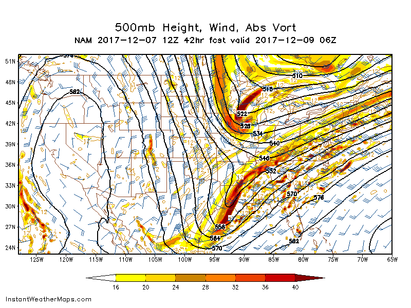
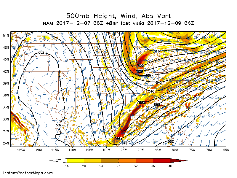
Here is 5h at 42 at 12z and 48 at 6z. Noticeable difference with the base.
-
2 minutes ago, wncsnow said:
Precip still struggling to make it into VA, better though for WNC
Yea precip just dries completely up, even with the gulf connection.
Edit: Tell you what though, this is a continuing trend here. We are still somewhere around 2 days away. Keeps trying to tilt the trough more and there may be a surprise in the cards.
-
Nam at 36 has some light precip showing up in eastern TN now. The base of the trough is really trying to take a swing here now.
-
3 minutes ago, FLweather said:
I agree looking at WV loop. That one Tiny piece of Shortwave energy diving southwest from CO to NM to AZ may help keep the energy more consolidated. Not ATM outwest shows a major wrapped up closed h5 from TX to NC. But maybe stronger in sense. Last few frames looks like its wetter maybe more NW push of moisture over TX and NM
The northern energy diving out of Canada this run is not impinging as much on the trough, allowing it to bend back some. This run has that energy a little more northwest of where it was on 6z. Interesting to see what affect this has in upcoming frames.
-
Lol the NAM is trying again at 30 to tilt the trough more neutral. Don't know if it will manage in time to have any meaningful affect for all of us.
Edit: Much better expansion of qpf in western and northwestern MS/AL
-
10 minutes ago, packbacker said:
To bad...if that piece of energy diving in over Wisconsin was diving in over Minn it might be different.
I still think that the "digginess" involved with the northern stream energy is somewhat stronger than progged and may have some type of adverse affect on the tilt of the trough. It seems to be responding to that energy if you examine 5h closely.
-
1
-
-
11 minutes ago, packbacker said:
GEFS still in the slow down and closer to coast mode...

Man crazy to watch the trough take a bend backward in the last frame there, in an attempt to try and go neutral.


The December to Remember 7th-8th blue turd winter threat thread.
in Southeastern States
Posted
Wncsnow #crushedson!