Buddy1987
-
Posts
4,178 -
Joined
-
Last visited
Content Type
Profiles
Blogs
Forums
American Weather
Media Demo
Store
Gallery
Posts posted by Buddy1987
-
-
The low on 3k is jumping around like crazy between hr37-40. I’m guessing it has to do with the convection and dynamics and what not.
Hr 42 has the low over Tallahassee, whereas 12z had it southeast of MYR
-
Just now, SimeonNC said:
Rock Hill, Ballantyne, Pineville, etc. all get clobbered with ice.
Ice is def nuts this go around down that way. Stay safe if it comes to fruition.
-
-
NAM scrapes the coastline this go around and has the low subsequently go from CHS at 48 to MYR at 51 and then a position JUST south of the outer banks at 54. Better track for the foothills and mountains of NC/VA. Gonna be some good weenie maps.
-
 1
1
-
-
Precip is much more expansive at 48 into eastern KY. Gonna be a great run for northern areas that are close to the fringe line this go around. RIC to ROA and down to the NC mountains are getting smoked! Low is literally JUST south of CHS, whereas 12z already had it e/se of Wilmington.
-
Just now, franklin NCwx said:
This is gonna be one of those nam runs of the past!!
Couldn’t agree more getting me giddy seeing the precip to my west and southwest on that run. Maybe this is the time frame Grit, myself and a lot of other people mentioned the precip shield correctly portraying this beast.
-
Just now, burgertime said:
This run of the NAM looks like it's slower with the LP system as well. Def a lot less wet for the I-85 corridor out to 27.
Burg, if the system is slower does that help the n/s turn it more negative or is that negligible at this point?
-
3 minutes ago, NCSNOW said:
They from the same family of programers
Ahhhh so I see! I did not know that.
-
12 minutes ago, olafminesaw said:
I never know quite what to make of the RGEM. It always seems to have strange convective blobs.
Is it known to be amped?? I know it can tend to have a cold bias.
-
4 minutes ago, burrel2 said:
Don't believe I've ever seen the RGEM so far off from other model guidance at 48hrs. It has the primary low still back in alabama while every other model already has the primary transfered to the georgia coast line.
Hopefully it's on crack, but it's much warmer than other modeling as a result.
Yea the RGEM is straight nuts Burrell. Huge squall line modeled along with much more northern extension of snow with it. Lends credence to CMC that it may not be completely on crack. Kind of nuts with how close the event is now.
-
4 minutes ago, wncsnow said:
The 12Z runs have al nudged the precip back north some which is good for some in VA like me
@Disc @wncsnow @BornAgain13 Got to like the trends here at 12z. The RGEM is straight sexy! Has a completely different solution though. End of the 48hr run it tries to do some type of transfer with the low over Alabama. Big snows look like they would reach up here. Plus that is one hell of a squall line approaching northwestern FL. Goes to show the dynamics with this system. RGEM/3K/ICON/CMC ftw!!
Euro looks improved as well!
-
 1
1
-
-
Just now, CentralNC said:
CMC is out to lunch. No way this storm goes that far north
I will say the 3k nam is not that far off from it, at least up this way. Never say never it’s nailed these things several times before.
-
18 minutes ago, BornAgain13 said:
Both Old and New GFS continues the trend south... also the new 06z GEFS follows south into NC , waving back at VA saying see you another time.
James,
6z Canadian still looks really good for us. Let me know if the link worked
-
Canadian looks more like nam. Precip shield is more expansive on the northern side. I’d love to post images but my dumb a** forgot my password for American Wx site.

-
 1
1
-
-
Just now, wncsnow said:
.5 moisture makes it to VA state line thats it
 Just now, BornAgain13 said:
Wow that is a huge shift south on the 0z GFS...
I don’t believe the gfs for one second, unless everything starts doing this. Not wishcasting but the low is really not that far off from the same time frame on the 18z panel. Obv I worry about dry air intrusion from the HP up to our north and have worried about it all week but I just don’t see it being a final solution. Crazier things have happened.
-
1 minute ago, beanskip said:
0z GFS basically just shifting every feature (cold air/precip/low pressure center) south throughout the run.
Do you believe it Bean? I cannot believe how much it made the northern precip vanish.
-
GFS looks north at 36 see if it adjusts here.
Edit: Looks similar at 42 now LP wise.
-
2 minutes ago, tarheelwx said:
I thought RGEM was excellent for temps in CAD situations. Anybody confirm?
TW
It has a bias to be too cold.
-
 1
1
-
-
1 minute ago, wncsnow said:
This is a great run for my neck of the woods over to Boone. Maybe the nam is overamping things?
The nam has a mind if it’s own. No amp in it at all until now. I don’t think it’s amping tho as some alluded to it’s simply expanding the qpf shield like most thought it would as it got closer to game time.
-
Wow the NAM absolutely ravages southern VA on this run. The clown maps are going to be ridiculous. I’m getting the laptop fired up so I can post images tonight.
-
Does anyone have any correlation to what “weaker” lows have with a significant and untapped potential regarding tropical connected moisture from the Baja vs lows that bomb out and almost make there own moisture flux say from the gulf? I read some interesting things on what @olafminesaw posted on that hamster link and I feel like after reading that this may be one of the “big” ones for the lower mid Atlantic and the southeast. That tropical connection, along with pwats, waa and subsequent atmospheric processes should lead to some serious rates of snow and in my opinion one heck of an expansive qpf shield, maybe more so than what the models are predicting. Wanted to get an opinion from a met or a pro in regards to this, if there was any studies done or anything like this. This southern low is traveling a long ways and picking up immense moisture along its path.
-
 2
2
-
-
1 minute ago, BornAgain13 said:
Out of everything I've seen so far on the 12z Data, what concerns me the most is the reduction in the GEFS
We still end up with like 1.50-1.75” nothing to be pissed about. Even if we got an inch we’d still be looking at close to a foot. We’ll have winter storm watches as well with this afternoons package guaranteed. Look at the positives here. FV3, Canadian and the GEFS moved the low closer to the SC coast this run. Qpf shield will respond for us. All is trending well right now imo.
-
-
1 minute ago, burrel2 said:
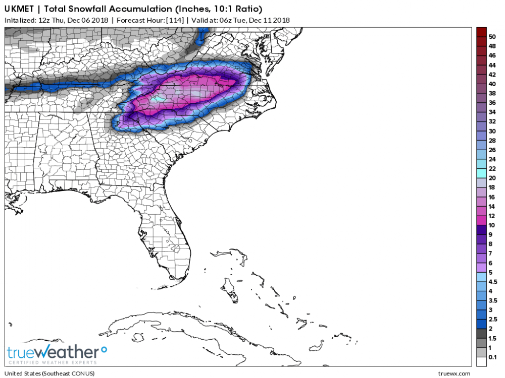
comparing hours 60 to 72 of precip panels with last nights ukmet and the 12z. The precip shield is definitely more suppressed, the high pressure is a good bit farther to the east, and the low pressure is a little slower. All good trends it appears.
Yup. Two camps setting up here. Ukmet and Euro vs FV3, to an extent GFS and the Canadian. Suppressed vs more north
-
 1
1
-

.thumb.png.c091e247523fb1b8be759f6bca0e8d3f.png)

December 8-10, 2018 Winter Storm
in Southeastern States
Posted
Yup. Plus to maximize accrual you’d want to have temps in the upper 20s to have it stick to everything. Antecedent conditions will obv help as well with the cold weather of late.