

Buddy1987
-
Posts
4,178 -
Joined
-
Last visited
Content Type
Profiles
Blogs
Forums
American Weather
Media Demo
Store
Gallery
Posts posted by Buddy1987
-
-
@psuhoffman I have a question and Idk if it is beyond your or Bob's pay grade. So with my very limited knowledge the Model For Prediction Across Scales (MPAS) is supposed to help be able to help smooth things over top of TPVs and be able to more accurately predict these things beyond 6 days as that is the bar per say on where forecasting almost becomes a crap shoot per say for predicting these things. Do Rossby waves also have an effect on them to where you end up with a Euro or Gfs solution, both being polar opposites of an outcome imo? Basically very long story short what would ultimately cause the TPV to elongate or remain intact per say and do you feel like this is what is going to cause the ultimate outcome in the H5 pattern to get us a MECS or a heatwave for dec standards?
-
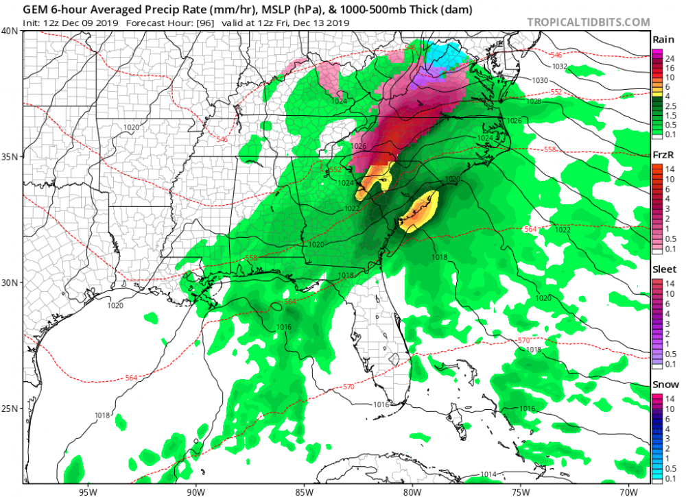
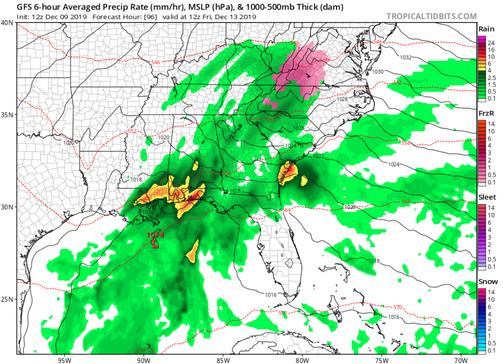
To note for Wow and Grits posts we need the TPV to not elongate along the Canadian border and consolidate the bowling ball of 50/50 blocking up un eastern Canada otherwise it's a torch instead of a HECS. Not asking for a lot but with the law of physics I dont think anyone really knows the answer until we are at least 7 days in as to what H5 may actually look like. 12z GFS really showed us what COULD happen if the stars align while Euro shows what our doom and gloom has been this early in the season for years on end. Both models are about as far as you can get for polar opposites. Euro basically feeds a western trough with east coast ridging and the GFS feeds the TPV into the 50/50 while also having a banana high type structure and producing a textbook miller A for us.
-
4 minutes ago, Ralph Wiggum said:
It probably wouldn't take much separation with the NAO trying to build-in to force things South. The ens spread between sliders and cutters verifies this. As many have alluded to, best case is a thump to meh scenario. The direct hit/in between look is unlikely.
Plenty of chances moving forward though. I feel like we have been tracking for well over a month already and it isnt mid December just yet. I know there isnt a whole lot to show for it but we are off to an early start and the recent years' Dec fail patterns are non existent. Give us chances....we will score.
Anyone who would contemplate complaining about a front end thump would be off their rockers. I would be more than happy to get something that is of the frozen variety. Long way to go with all this but as many alluded to many positive signs both short medium and long term.
-
 1
1
-
-
1 hour ago, Wow said:
I think the time period beginning 10-12 days from now has some promise
Nice to see you post. Speaks on the potential. Takes a near perfect track for the northern viewing area. Low tracks from Columbia to Richmond. Near perfect track climitologically speaking for a massive snow storm for I40 north coupled with a HP anchored up around the Toronto area supplying us some fresh cold air from Canadian origins. God I hope that comes to fruition. I always feel like these long range precursors from multiple model suites have some type of legitimacy behind them and signal that some of the biggest storms for the area have a rhyme and reason behind them.
-
1
-
-
46 minutes ago, mackerel_sky said:
Hug the NAM
Mack you win man. Nam caving in my opinion. Brief onset in places but even up here 3 to maybe 6 hours of freezing rain and then transition. HP just getting booted way too fast. Next week def looks interesting but then again that always happens and then as we get closer some dumb northern great lakes low or something impedes and squashes our chances. Good to see consistency between the GFS and Euro at this stage. Sometimes big signals are a tell tale sign of things to come.
-
11 minutes ago, mackerel_sky said:
Hug the NAM
Hug the Canadian lolll
-
9 minutes ago, Weatherzim said:
What's the nam saying
Sent from my SM-N975U using Tapatalk
Only out to hr 35.
-
Just now, mackerel_sky said:
In situ wedging. Precip evaporating forms kind of it’s own high pressure, locks in cold, with high already gone
I get that but the 2m dews are a solid 6-7 degrees cooler up this way and a good several degrees cooler over western NC
-
Can someone explain to me with a little more knowledge how we end up with cooler 2m temps in southern va and a good chunk of west central NC with the high exiting stage right compared to 18z? Is there some sort of meso high that's not on the map I am missing allowing damming?
-
12 minutes ago, AsheCounty48 said:
0z should be interesting, roll the footage!!
Looks like 0z Nam has the high hauling ass out of there compared to 18z. Pretty pronounced too whereas toward the latter portion of the run 0z has it nova Scotia while 18z still had it in southern new England. Waiting for 2m temps to catch up as the frames are still back at 57hrs
-
2 hours ago, lilj4425 said:
Oh you shouldn’t have.
 I would love the honor. I bring mojo.
I say go for it for 0z runs
-
1
-
-
26 minutes ago, mackerel_sky said:
I’d be willing to bet it closer to reality than the NAM!
I'll wager non event for you moderate event for me! Winner gets....???
-
 1
1
-
-
25 minutes ago, mackerel_sky said:
GFS is still 90% rain, for everybody! A non even
GFS is garbage with storms like this. I dont buy it for a second. Take it with a grain of salt. Its built more for medium to long range
-
1 hour ago, Disc said:
Speaking more for southern VA here... The is a very dense arctic airmass that is moving across the northern parts of the CONUS. This airmass will obviously moderate some, but it will still be very dry and will be hard to scour out once the precipitation begins to fall into it. I've seen some of the best CAD favored areas hang onto below freezing temperatures for an entire duration of an event even with a retreating high. While yes, ZR is self-limiting and the high is transient, these mountain valleys are incredibly hard to "warm" once the low-level cold is locked in with precip falling.
The lighter precipitation at the start with temps in the mid-20s is very much a concern. 6-8hrs of that and you have a mess. Like usual, I'd be most concerned about the Blue Ridge and areas just to the east.
Only concern I have and that directly revolves around the fact of whether or not someone actually enjoys ice storms is the placement of the HP and where it is parked. If you're looking for optimal placement you'd like to see Schoharie Valley/Upstate NY for optimal funneling out of the St Lawrence Valley. In contrast NAM has it placed in eastern NY and CT sliding toward SE CT and RI. Although it's not in "optimal position" a 1043 is plenty a strong to supply what is needed before we all warm up. As you alluded to the dense nature of it spells trouble to me as you see 2m temps in SW VA around 10 degrees or so and even low 20s into SW NC mountains. I've been through plenty of these when I lived in CT therefore anytime the models start to show a continued theme of low level cold air being pumped into the area one should take notice. A high that strong can and does over perform to lock in that air.
-
9 minutes ago, osfan24 said:
To each their own, but I've never understood the fascination with freezing rain. It's just incredibly dangerous. I guess it can look really pretty if it really accumulates? Also have to worry about power issues. Also hate those storms where you can the initial thump of snow to rain. Kinda pointless when it literally washes away in a few hours.
I just more or less appreciate something other than rain to where it's some form of winter weather. Guess it helps a lot of my power is all ran underground in new development lol but still just a genuine winter enthusiast.
-
10 minutes ago, NorthHillsWx said:
I would agree with you there. Salem looks to be one area I'd flag as still having the potential for a significant event here. Just because it may be more localized and fewer posters on this forum will see much of anything, it does not mean some areas could receive a significant storm.
12z gfs trended faster and also more in line with low trajectory closer to coast then a cutter so there's that..
-
@WinterWxLuvr wasn't really sure where to post this as there's no dedicated header to post under but I thought for folks like yourself and up the 81 corridor would have some interest in the Fri timeframe. Canadian and Nam are spitting out some pretty crazy freezing rain potential. 12z looks ominous even if it's only half the amount.
-
10 minutes ago, ams30721us said:
Timing is going to be big as usual with this type of setup. The past few days, most models were delaying the onset of precipitation till during the day Friday, and into Saturday.
Just noting the early 12z data today, has shifted back to an earlier onset, Thursday evening, leading to a colder/drier airmass, and allowing for a slightly better signal for some icy concerns by Friday morning.
Also, the GFS seems to become quite amped up with an inland tracking surface low up closer to the Apps, while the other guidance is indicating a low tracking further east along the coast.
In the end, this may not matter much as the high slides out during the day, Friday leading to a narrow window of opportunity.
Just a few thoughts to monitor in the future trends.
Appreciate your input. My concern is I'm in a rock and a hard place because I could qualify per say for both SE forum and Mid Atlantic with my geography. A lot of times more of the concern in this sub forum is for Raleigh/Charlotte and I-40 and south. Dewpoints up my way are single numbers to low teens signaling this could be more than a nuisance or minor as you cross the NC/VA border with potential for prolonged icing.
-
1
-
-
52 minutes ago, burrel2 said:
84hr NAM appears to be setting up a crippling ice storm.
Nam and Canadian a dangerous combo when they show this. I put zero stock into the GFS at this juncture as it "sucks" calling a spade a spade at depicting low level cold. Friday becoming more ominous in my opinion. Yea I know its 84 hr nam but hard to discount when both computer models that have a superiority in that department spit out some of the freezing rain output. Time will tell
-
38 minutes ago, mackerel_sky said:
GFS 18z all rain, even for N.C., I’m shocked!
31 minutes ago, RT1980 said:I thought you said frozen north of 40? I’m shocked!
18z Canadian is still ice ice baby! I would lend more credence to depiction of high from Canadian. Not the easiest to dislodge low 1040s HP.
-
39 minutes ago, Iceagewhereartthou said:
Meh... it's the Canadian, we're safe.
I always assume cut the totals in half with qpf output. Even still crippling if it came to fruition.
-
23 minutes ago, msuwx said:Canadian often does pretty well with CAD, especially its regional model.Here's the deal though....all models, operational and ensemble, essentially show there will be an arctic high moving from the Great Lakes through the Northeast US and then out into the Atlantic late in the work week. Thursday through Friday afternoon appears to be the time when the high will be in very favorable cold air damming position.The trend later yesterday and overnight was for most of the models to hold the most significant precipitation off until just after that prime CAD time range, when the high is slipping out into the Atlantic.It would only take a subtle change in timing for there to be significant ice concerns in the normally-favored cold air damming regions. The Canadian solution is not terribly unlike its previous runs...just a little more defined and slightly quicker with its 500mb feature, thus resulting in precip exploding while the high is still in prime CAD position.Bottom line, most likely the timing won't work out for significant ice problems, but it certainly remains within the realm of possibility.
For me last year the Canadian scored some pretty big coups in my opinion. I wouldn't discount it whatsoever for this, albeit I havent looked at model verification to see how it's been performing since last winter so my theory could be flawed. Anyhow this event in particular isn't so much in my opinion the cold source it's more as to whether or not the precip can get in here while damming is still prevalent. CMC and NAM perform best when verifying strength of cad therefore we just need the precip to behave (that is if you personally like ice events). This has been an ever changing synoptic setup and has swung pretty wildly since I started tracking a week ago when models started to hint at the possibility.
-
Snowing down in Roanoke. Nice to see flakes this early. Good luck to the DC crew up that way.
-
1
-
-
Snowing in Roanoke. Nice to see flakes this early. Hopefully the precip shield will get a bump here by mid morning from the vort.
-
1
-


Mid to Long Term Discussion 2019
in Southeastern States
Posted
Very weird evolution where the low is super "jumpy" I still believe it's a threat tho. Need that stout HP to help the storm say suppressed compared to what the storms have been doing lately.