

Buddy1987
-
Posts
4,511 -
Joined
-
Last visited
Content Type
Profiles
Blogs
Forums
American Weather
Media Demo
Store
Gallery
Everything posted by Buddy1987
-
Ice Time? Dec. 16ish Possible CAD Event
Buddy1987 replied to Tar Heel Snow's topic in Southeastern States
18z nam coming in colder at least for northern areas. Trying to start off as all snow up this way and icy mix further south -
Ice Time? Dec. 16ish Possible CAD Event
Buddy1987 replied to Tar Heel Snow's topic in Southeastern States
Damn it’s way colder up this way.. I would not want to be Blacksburg for this one. Lose lose IMO -
Ice Time? Dec. 16ish Possible CAD Event
Buddy1987 replied to Tar Heel Snow's topic in Southeastern States
What did 12z euro show? I have limited access because of work. -
Ice Time? Dec. 16ish Possible CAD Event
Buddy1987 replied to Tar Heel Snow's topic in Southeastern States
Welp.. after seeing 12z gfs this is now the theme. Maybe we can get lucky and eek out 1-2” quick but looks to be a predominantly icy event here. -
Ice Time? Dec. 16ish Possible CAD Event
Buddy1987 replied to Tar Heel Snow's topic in Southeastern States
Regardless 12z nam does not look fun wrt ZR potential. Right around .60 so even half of that would be pretty bad. Would say it’s kind of weird to see the nam so much warmer than gfs but reality is nam is super amped and gfs is more progressive in nature. Tough forecast at least for my area. If I were a betting man I’d probably go 2-4” then .15-.30 glaze -
Alright ladies and gents. About T minus 0. The most important run of our weenie lives. I’ve heard all the big boys and girls talk about 0z Monday being thee run to be ready for, as sampling etc would be available to our main player. Here’s to getting destroyed on the upcoming model runs!
-
Usually starts running at about 1020pm or so
-
Anyone have a simulated radar from start to finish?
-
Ice Time? Dec. 16ish Possible CAD Event
Buddy1987 replied to Tar Heel Snow's topic in Southeastern States
Yea man that’s the problem with it being mid December. I-40 south it’s just not time yet in my opinion. Usually takes a lot even up my way (1038mb) high pressure. I will post some pics for you guys with whatever happens. The long range looks pretty damn good. There will be another medium range threat that pops up. I will bet on it. -
@clskinsfan P17 you and I can go ahead and shake on. I’ll take my foot plus so you can have your two foot plus. Man that’s a BECS
-
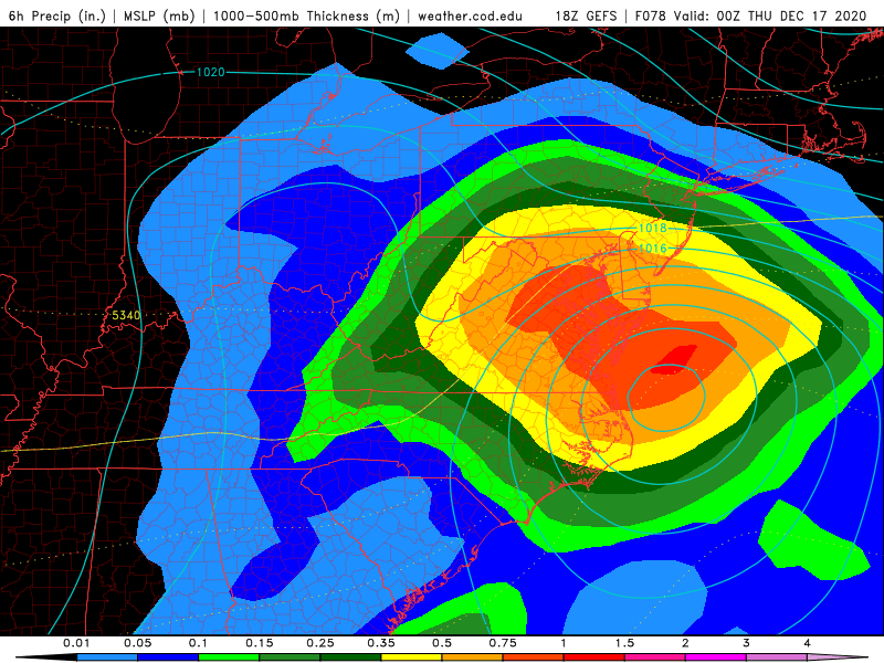
Man that is just crazy from the GEFS with banding expectancy.
-
@BornAgain13 you never flip to plain rain on 18z gfs and it is trying damn hard to predominantly snow up this way. Maybe some sleet mixing in at end of the storm basing it off cod website.
-
Wow hell of a run! That deform band is just dumb from 78 on. GFS has been very consistent now for multiple runs overall.
-
72 looks ever so slightly more progressive as low placement is already NE of Wilmington while 12z was just off MYR
-
IMO even more pronounced at 60. You can see the lines wedged down into GA bend further south/southwest.
-
To my eye 42 looks pretty good thus far at 5h. Energy is a little further south in the plains. I’m hoping it translates downstream as the run plays out. Confluence looks fairly unchanged.
-
That model is hot garbage. Worse than even the model Nogaps back in the day, wayyy worse
-
Icon looks like it has better wedging at 18z vs 12z around hr54
-
Big Bills fan. Love seeing MIA get their ass kicked I realize we’re not going to catch KC for best record AFC
-
Ice Time? Dec. 16ish Possible CAD Event
Buddy1987 replied to Tar Heel Snow's topic in Southeastern States
If you think the GFS is right even you don’t flip down that way. You can put GGEM in that grouping as well. I’m talking about plain rain let me be specific. I think you may start and end freezing rain and have a significant amount at that. -
Ice Time? Dec. 16ish Possible CAD Event
Buddy1987 replied to Tar Heel Snow's topic in Southeastern States
I still think you’re gonna hang onto 0 850’s for awhile longer than what’s modeled. 1038 high or so will be no joke -
Ice Time? Dec. 16ish Possible CAD Event
Buddy1987 replied to Tar Heel Snow's topic in Southeastern States
@Blue_Ridge_Escarpment @griteater how are you guys feeling about northern NC mountains up to this are and south of I-64 in general? My goalpost was for 3 or more inches I’d be beyond belated. I think at least for my specific area I can achieve that before zr/pl kick in. Looks close to 1” liquid from my area and to the north/northeast. -
Much colder! Don’t even need to look back to see I’m -4 out this way at 1pm when I was flirting with 0/-1. That’s a plus for others at that point too.
-
Ladies and gents track ain’t gonna get much better than this here. This will make everyone extremely happy for the most part.
-
I think Cape nailed it perfectly. We want to root for a more progressive system rather than allow it time to amp back over the plains and lower Mississippi otherwise the low track will not appease everyone.


