heavy_wx
-
Posts
1,628 -
Joined
-
Last visited
About heavy_wx

Recent Profile Visitors
4,270 profile views


-

Feb 22nd/23rd "There's no way..." Obs Thread
heavy_wx replied to Maestrobjwa's topic in Mid Atlantic
Measured just over 2" of snow depth on my car in North Bethesda. There's still some light snow coming down but I don't expect any more measurable accumulation. -
Feb 22nd/23rd "There's no way..." Obs Thread
heavy_wx replied to Maestrobjwa's topic in Mid Atlantic
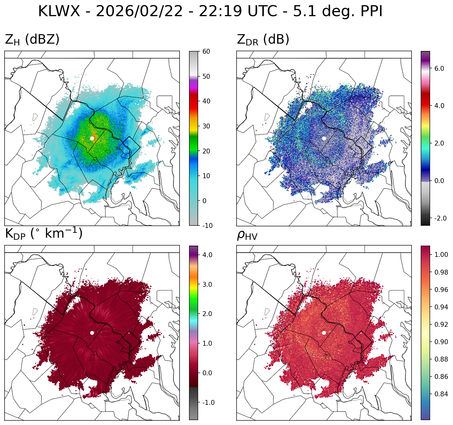
There's some indication of a dendritic growth zone signature in the polarimetric radar observations from KLWX. The ring of enhanced ZDR and KDP align roughly where the radial gradient in reflectivity is greatest, indicating rapid growth of ice crystals through vapor deposition and aggregation. These crystals tend to stick together efficiently and help produce large aggregates. Temperatures near freezing at the surface also favor larger particles.
-
Feb 22nd/23rd "There's no way..." Obs Thread
heavy_wx replied to Maestrobjwa's topic in Mid Atlantic
We're getting noticeably bigger aggregates now with this band of ~30-dBZ reflectivity moving through MoCo. -
Feb 22nd/23rd "There's no way..." Obs Thread
heavy_wx replied to Maestrobjwa's topic in Mid Atlantic
All snow in North Bethesda with small/moderate-sized aggregates. -
Feb 22nd/23rd "There's no way..." Obs Thread
heavy_wx replied to Maestrobjwa's topic in Mid Atlantic
Rain with a few partially melted snowflakes mixed in here in North Bethesda. -
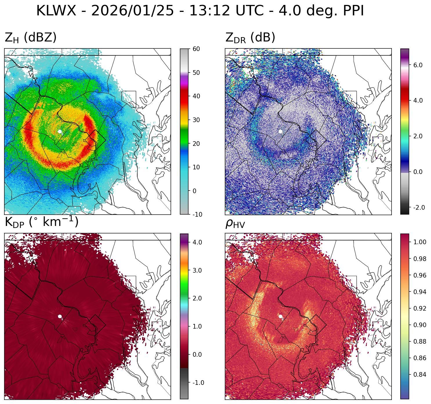
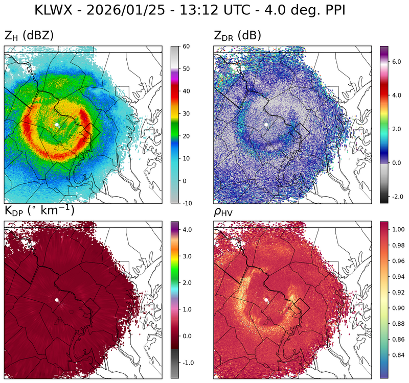
The transition to sleet here in southern MoCo lines up pretty well with the low RhoHV and high reflectivity on the 4-degree PPI scan from LWX.
-
Just changed over to sleet here in North Bethesda.
-
There is likely some partial melting of the aggregates, ahead of the more visible reduction in correlation coefficient, causing the ice particles at the surface to become more compact. A mix of fully melted liquid drops and partially melted ice particles is typically needed to produce the observed reductions in correlation coefficient within the melting layer.
-
I measured just over 4" of snow here in North Bethesda with moderate snow falling currently. The aggregates are mostly compact indicating less than optimal snow growth at temperatures > -10C and possibly some riming. I did see a few dendrites mixed in so there is still some growth occurring at temperatures < -12C.
-
Measured about 5" of accumulation here. There are currently some large aggregates falling within the region of 30+dBZ reflectivity in southern MoCo.
-
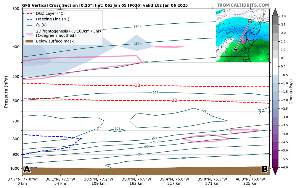
Interesting signature for banding in the 06z GFS (and 06z 3-km NAM) around 12z-18z Monday, just as the dry air starts to work in above 600 mb. This dry air above the lower-level moisture produces convective instability above the frontal surface between 750-650 mb south of the frontogenesis max around 800 mb. This instability would favor vertical motion and ice crystal generating cells just to the north of the approaching dry air. Given the temperatures > -12C and the likely presence of supercooled water, graupel is a definite possibility within this area of precipitation.
-
We are within the ~25-dBZ reflectivity band here and getting steady light snow with mostly small aggregates.
-
We're getting some flurries here now.
-
Saw the bright pink colors here in southern MoCo.
-
Getting some melting snow here in the heavier bursts of precip.