Windspeed
-
Posts
4,613 -
Joined
-
Last visited
Content Type
Profiles
Blogs
Forums
American Weather
Media Demo
Store
Gallery
Everything posted by Windspeed
-
 Very clean microwave during landfall. Distinct concentric features with an ERC in early stages. Two wind maxima were probably experienced in Tinian and Saipan with the larger outter band and insanely intense inner eyewall. Infared can be deceiving for exact path of the wall over those islands as well. The Himawari satellite is positioned at a plane of lower latitude and at an acute angle south of the typhoon. IR images reflect colder cloud tops that only start to resolve at the mid-to-upper level of the eye. You must account for the height of the eyewall cylinder down to the surface at that distance. A visible image with sunlight at the same angle will show the lower-level circulation, closer to the surface, at the bottom of the eyewall cylinder. It's frustrating we don't have observable radar for a US territory besides, but it is what it is. Luckily we did have the clean microwave scan at landfall. And perhaps the airport/military will have some closed network remote sensing before all hell broke lose; and hopefully some instrumentation survived for pressure distribution.
 -
Yowza! I probably over use maximum potential even if there are cases where the environment isn't perfect. But in Yutu's case, it is definitely maxing out. Almost looks as insane as Haiyan. Almost... I am noticing a subtle bend back towards a more westward component in the extended loop. Not sure if that is merely short term, but hopefully that allows Yutu's intense core to miss Tinian/Saipan or any other population centers for that matter.
-
An issue for any vertical city is wind funneling. You may have 70 kt sustained at the airport, but in downtown with skyscrapers, off the bay, etc., wind will have greater effect and look more intense.
-
The GFS continues to be annoyingly overblown on intensity modeling. Jebi at 918 mb just off the coast while imbedded in strong SW mid level flow? No...
-
Updated track and intensity guidance for Jebi.
-
Be careful with use of that word imminent in describing an increased probability of a significant earthquake. Though there has been research that has tried to link small and prolonged seismic signals to tidal stresses, there has yet to be any substantial evidence correlating a single large seismic event based on the tidal influences and lower atmospheric surface pressures of a tropical cyclone. Simply put, there is yet no known mechanism to forecast failure of a fault based on a single weather event such as a tropical cyclone. The stresses of rock deformation, elastic and isostatic rebound are many factors exponentially greater on scale than to that of any atmospheric pressure influence by a single weather event. We also have too many examples of strong typhoons hitting Japan with little or negligible large seismic event observed. There is simply no evidence to support such a precursor, much less a prediction. However, Japan is always under threat of a strong seismic event simply due to the many active thrust faults there besides. So a threat is always high compared to other populated geographic locations regardless of what is occurring in the atmosphere. The same strong mid-level trough responsible for steering Jebi towards Honshu may also phase it. This will be a timing issue but I agree that Jebi has a good chance of being a significant strike. There may be mid-level shear impeding upon Jebi as it approaches landfall, but SSTs are still running 27-28°C off the coast there, so though I do expect quite a bit of weakening, it could still be packing 100+ kts. Could be a damaging event. Those folks are seasoned to handle it, however, though I am certainly not downplaying the threat.
-
JTWC now has Jebi classified a Super Typhoon at 140 kts.
-
The setup for early-to-mid May could be a volatile one for strong storms for the Mississippi and Tennessee Valley. Potent shortwaves enhanced by southwesterly jet out of Mexico, cooler than normal upper levels in May, advancing dry lines out of Texas, strong bulk shear, etc.; it only takes one of those surface lows to come in line to make for a memorable event. Yes, obviously not wanting to overhype so far in advance. Yes, it's Spring and there shall be storms with increasing juicy Gulf moisture as per the norm, but the atmosphere may very well be conducive for at least one strong Southern outbreak.
-
Summary on the Jacksonville, AL tornado that was rated an EF3. Considering the area it passed through, it's amazing there were no deaths and greater numbers of injured. https://www.weather.gov/bmx/event_03192018_jacksonville
-
Haha nice work, Josh! I headbanged a little. Good luck on your chases this year. May they be as successful as 2017, though hopefully less witnessing to devestation of densely populated areas. Edit: *2017
-
Marcus is traversing cooler waters and weakening as expected. Without respite, however, another cyclone is intensifying rapidly out of the Torres Strait and moving into the Gulf of Carpentaria. Cyclone Nora already has a clearing eye surrounded by -80°C tops and is on the way to becoming severe. The system is moving through an increasingly favorable environment for significant intensification and could interact with land as an intense cyclone. A more unfavorable environment late on the forecast period and slow movement may allow weakening prior to landfall of the cyclone's core. But that same slow movement may exacerbate flooding.
-
Marcus will definitely be among the most powerful tropical cyclones of 2018:
-
Severe Cyclone Marcus is a Category 5 on the Australian scale. It would probably be a Cat 5 on the US and Japan scales at some point as well. The cyclone looks to have completed an ERC and the eye that was partially covered in cloud debris appears to be clearing again. Dvorak is closing on AdjT#7 and 135 kts. The CDO is symmetrical with a thick ring of -80°C tops and MW representive of an intense eyewall. Here's the current Aus Met advisory:
-
That was likely a violent long-tracker unfortunately.
-
I was referring to the cell between Cullman / Good Hope i65 and Arley, AL. Though the rotation has weakened now.
-
Cell ENE of Arley, AL probably about to be tornado warned.
-
Cullman cell is intense. Looks like they are getting rocked with possible 2-3" hail over downtown.
-
The strong cell / updraft SE of Addison, AL looks like it may be on the verge of producing. Signs of a couplet forming.
-
Cell near the state line is bearing down on i-65. Looks more and more impressive. Will pass very near Ardmore.
-
That's an impressive donut meso on the state line cell...
-
That cell near the AL/TN line may be trying...
-
This was earlier as the couplet was moving through Russellville.
-
Tight couplet west of Russellville, AL.
-
That is a nasty hail core on the super cell near Belmont in Tishomingo County, MS.
-
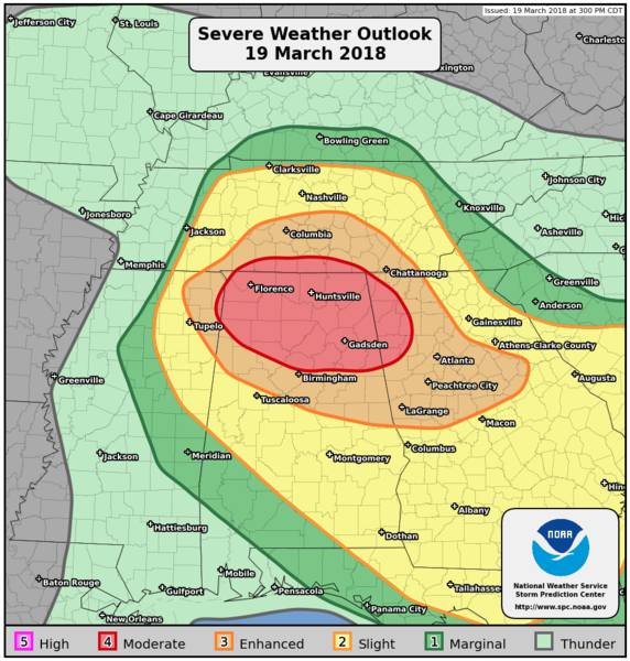
Today's SPC PWO risk graphic for posterity.