-
Posts
4,734 -
Joined
-
Last visited
Content Type
Profiles
Blogs
Forums
American Weather
Media Demo
Store
Gallery
Everything posted by Windspeed
-
2024 Atlantic Hurricane Season
Windspeed replied to Stormchaserchuck1's topic in Tropical Headquarters
Dr. Jeff Masters and Bob Henson break down the much-discussed quiet August period of the 2024 Atlantic hurricane season: Where are the hurricanes? The Atlantic’s late-August nap may lead into a stormy September -
I'm not convinced that westerly shear is the culprit for weakening here. I think the problem a TC experiences in its current location is downsloping off of Kyushu's mountainous terrain. About 12 hours ago, there was a pass that showed significant deformation in the eyewall and a replacement cycle in progress. Then, the entire western band disintegrated as the northern circulation moved over the greater Kyushu landmass. If you watch satellite and radar animation through the same timeframe, it's rather neat to see the landmass of Kyushu having effects on Shanshan's structure. I agree we're looking at a Cat 1-2 in windspeeds, most likely. But in hindsight, this is a massive typhoon and large circulation. A dangerous situation is unfolding if it continues to crawl at a slow pace through landfall and progresses slowly over the Kagoshima prefecture. Precipitation amounts may lead to a historical event, unfortunately.
-
Shanshan is now a Category 4 typhoon. The storm is crawling, but its large symmetrical eye is maintaining a very stable and steady state. It is churning up deeper water, but not feeling its own effects of upwelling due to the 26°C isotherm being over 100 meters deep currently in that part of the NW Pacific. High TCHP is critical for slow-moving large TCs to maintain such intensity for long durations.
-

2024 Atlantic Hurricane Season
Windspeed replied to Stormchaserchuck1's topic in Tropical Headquarters
A vigorous AEW should be exiting south of the Cabo Verdes by Wednesday. This disturbance is at a lower latitude and has intensified over the past 24 hours. The cyclonic spin is quite noticeable beyond a typical mesoscale feature and may already have an organized low. Based on its look and latitude, it has my attention. Note that the image was sourced from Meteosat and not GOES to get a better perspective of the wave at 5°W to avoid distortion. -
Shanshan completed an ERC and now has a larger diameter eye. For now, it looks like the Kagoshima Prefecture will take the brunt of landfall. There is also potential for a stall inland over Kyushu before moving back out over open water. Modeling has not performed the greatest with Shanshan up to this point, however, not handling the steering layer well around large features such as the typhoon's interaction with the mid-to-upper cutoff and weak steering flow with a potential block to the north.
-

2024 Atlantic Hurricane Season
Windspeed replied to Stormchaserchuck1's topic in Tropical Headquarters
Excellent thread by Kaylan Patel covering the quiet August stretch. He includes the abnormally strong monsoonal trough latitudinally displacing WAM/ITCZ like we have also discussed and also mentions a stable upper troposphere over the MDR. He mentions the +NAO and SPH placement tapping SAL. But I do like his play-by-play of the resulting pattern here: He also alludes to the EPS and GEFS showing the monsoonal trough weakening. These are all topics we've covered above but a nice succinct thread here. Just to show a lot of discussion ongoing across SM by the pros and further implications that the quiet period may be closing. -

2024 Atlantic Hurricane Season
Windspeed replied to Stormchaserchuck1's topic in Tropical Headquarters
Yes. lol, interestingly enough, the sudden drop in the meridional and equatorial Atlantic doesn't seem to have weakened the WAM at all in July. In fact, WAM did the opposite and dominated. Perhaps one of the strongest in decades, influencing above normal precip across Sub-Saharan, Sahel. But it must be noted that precipitation has been above normal from the Arabian Peninsula to Morocco. So it's not just West African. Something else is going on, but it does look as if WAM is finally weakening or backing off into a more supportive state for lower latitudinal AEWs. Edit: I should also clarify that if you want MDR TCs during ASO, you actually want there to be an active WAM in June and July but does not go completely away. If you have no WAM, AEWs are significantly limited in frequency and organization to limit MDR TC production. However, as we have seen this past month, an overly aggressive or potent WAM allows AEWs to gain too much latitude. SPH placement still pulls SAL into that region North of the CVs, not to mention cooler SSTs for thermal support. -

2024 Atlantic Hurricane Season
Windspeed replied to Stormchaserchuck1's topic in Tropical Headquarters
That is referring to the equatorial and meridional Atlantic Niño/Niña SSTa oscillation. Generally, AN SSTs enhance the WAM and ITCZ. BN tends to weaken them. There is a paper on this if you're interested. An Atlantic Niño can enhance the MDR where as a Atlantic Niña can limit the spawn of AEWs. But it's not as impactful versus ENSO's influence and other factors. You can still get an active MDR if meridional SSTs are BN. Atlantic Niño can enhance in combination with -ENSO, but certainly won't counter a moderate +ENSO. https://cpaess.ucar.edu/meetings/2021/pirata-24/abstracts/atlantic-ni%C3%B1oni%C3%B1a-influences-atlantic-tropical-cyclone-activity I should also add that the article you posted above isn't also referring to the SSTs across the North Atlantic basin. They are still very much above normal. -
Shanshan has positioned itself in a more favorable environment now for rapid intensification. The features that were holding it in check are now aiding in ventilation. Over the past few hours, intense convection has wrapped the core of the typhoon. Hopefully, the TC doesn't go too crazy and become a super typhoon prior to landfall.
-

2024 Atlantic Hurricane Season
Windspeed replied to Stormchaserchuck1's topic in Tropical Headquarters
Your only criteria for an "active MDR" only ever appears to be when we have a major hurricane in progress, and your posts are uncoincidentally absent. Only the 2021 season lacked a classifed TC in the MDR that failed to become a hurricane. 2023 saw four, one becoming a Category 5 while still in the MDR. The MDR is not going to produce long-tracking major hurricanes every season. Yes, we all know this. I'm not even sure why I bothered a response. Perhaps for everyone else who doesn't know your history and might become misinformed. -

2024 Atlantic Hurricane Season
Windspeed replied to Stormchaserchuck1's topic in Tropical Headquarters
LOL, nice try. We had a Category 5 hurricane in the MDR last year. We've already had a Category 5 hurricane that developed out of the MDR this year. -

2024 Atlantic Hurricane Season
Windspeed replied to Stormchaserchuck1's topic in Tropical Headquarters
WAM intensified and gained significant latitude in late July. The Sub-Saharan region, even portions of the Sahara have seen significant precipitation the past month. But if you recall, the ITCZ was at a low latitude and very active in June before WAM intensified. We have seen record downpours from the Arabian Peninsula to Morocco over the past month. Additionally, we've seen enhanced SAL plumes due to SPH placement across the central Atlantic. You may also recall that the AEWs that became Debby and Ernesto did not become convectively dominate until they reached the WATL. Both systems were choked of stable airmass. They eventually did moderate and develop, but only after mixing out SAL. -

2024 Atlantic Hurricane Season
Windspeed replied to Stormchaserchuck1's topic in Tropical Headquarters
Mike, where have you been? Lol... There's been plenty of discussion about the West African Monsoon and latitudinal placement. AEWs do not, or at least rarely, develop north of the CVs when they exit there. That being said, the WAM is losing steam, and it is modeled to do so. ITCZ placement should drop in latitude by September, and the SPH will shift into a more climatogical steering flow for MDR TCs. I actually think it is somewhat amusing that TC enthusiasts and pro tropical climatologists are all scrambling due to the approaching peak with limited model support. This is mostly due to varying ranges of significantly high named storms numbers. I think forecasting 25+ named storms is a huge risk to take in any year no matter the long-range ECMWF+UKMET superblends, climo patterns, or AMO or ENSO states. Too many caveats and anomolies can occur when all things look extreme. WAM placement and East Atlantic Nino being a perfect example this year. I should stress, however, that WAM will weaken, even if it is abnormally strong. You want some monsoonal enhancement to favor AEWs with a low-latitude ITCZ if you want MDR TCs. We're still going to get that the bulk of September. Sure, NS numbers may not hit all these crazy forecasts, but we will get active, and we will see intense TCs out of the MDR during that stretch. Back to the present, though the wave south of the CV looks good, modeling support is pretty limited. However, it doesn't look too bad right now, and bears watching. As it moves into the western MDR this coming week, the MJO may time just right to enhance development. Even if limited, some EPS support is there, and that could increase as we get into midweek. -
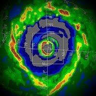
Hone has clearly organized further overnight and now has a clearing eye with multiple CBs rotating around it. Radar is also telling. The hurricane appears to have intensified. It will be interesting to see how the flow over the Big Island affects and influences Hone's structure. The Lee side of Mauna Loa and Mauna Kea's massifs will most likely have some type of deformation on the core as the hurricane positions SW of the island. In fact, that may already be occurring as the eyewall appears pinched in the NW quadrant. Also, keep in mind that the radar beam is blocked to the SW to N due to Mauna Loa.
-
NE quadrant was weaker than the previous NW pass. Interestingly, the NW quadrant of the eyewall had the most intense echoes. Not sure if this will be enough for any upgrade. Again, it's borderline. We'll see if they do a south to N for their final pass.
-
If officially upgraded, it will be, yes. With the current radar presentation and in situ recon data, CPHC may issue a special advisory, though they may wait on the NE pass to the reconfirm before releasing it. Edit: Latest VDM:
-
64 kt SFMR in the NW quadrant. Hone is probably a minimal hurricane now. We'll see what the next pass through the NE quadrant shows.
-
Improvement in structure on IR and radar due to persistent convective bursting that has occurred since the last recon mission. We'll see if this translates to any deepening via the recon mission currently in progress. Should have a new VDM within the hour.
-
So far, so good. Hone has failed to intensify further. Environmental conditons are managing to keep the TC in check.
-
Shanshan's mid-level vortex is being stretched due to close proximity to the mid-to-upper cutoff, which is now an intensifying ULL. The ULL has been evolving while imparting substantial shear across the TC the past few days. Interestingly, though shear has a negative impact in preventing Shanshan's core from developing a stable eyewall, strong diffluence (spreading wind vectors) around the ULL has already been aiding in strong convective bursting to keep the low-level vortex vigorously organized, and it is exactly this phenomenon that favors future rapid intensification. As the ULL retrogrades to the WSW and gains separation from Shanshan, it will flip from unfavorable to exceptionally favorable in mid-to-upper flow. The 400-200 hPa jet pivots away to create a mass sink to evacuate air. Diffluence remains, but you now have divergence aloft with poleward and westward channels. Simultaneously, Shanshan moves over relatively untouched SSTs with deep heat potential. So we're all looking at this thing with apprehension because, based on the evolving and modeled steering layer, this TC has the potential to be the most powerful typhoon to make landfall in Japan in decades. I am not saying it will. But you may still be dismissive of the high-end modeling (which is probably overdoing it) and are certainly justified to worry of an intense and destructive landfall.
-
Little change in intensity is expected in the next 12 to 18 hours, followed intensification Saturday and Sunday. Easterly winds aloft, which have inhibited outflow in all but the south and southwest quadrants, will relax tonight and Saturday as a weakness develops in the upper level ridge north of the cyclone. Sea surface temperatures will remain around 26-27C, which will be sufficient for intensification, possibly to hurricane strength, later in the weekend. By Monday, westerly vertical wind shear increases sharply, and some drier mid-level air appears to begin entraining into the system. This should result in steady weakening. The intensity forecast was changed little from the prior package and lies near the IVCN between the stronger dynamical guidance and the weaker statistical guidance. Easterly mid-to-upper flow has kept the core of the Hone rather devoid of convection today. The CPHC is forecasting that flow to relax on Saturday, which should allow convection to rebuild around the core. At any rate, this is the reasoning behind Hone's delay in intensification, and it isn't forecast to approach hurricane strength until positioned south of the island chain, having already bypassed the Big Island. In the last few hours, a new burst of convection is trying to wrap upshear.
-
The disturbance that may threaten Hawaii would be approaching from a direction that typically is not conducive for strong hurricanes. However, currently, SSTs are marginally supportive SE of Hawaiʻi Island (the Big Island) if our hypothetical TC can get going and establish an inner core. The shallow 26-27°C layer might provide just enough thermal support for a minimal hurricane that maintains a steady rate of motion. A compact structure may also aid in intensity. Hopefully, any potential TC, regardless of TS or minimal 'cane, would remain far enough south to lessen impacts, perhaps only to provide some beneficial rains.
-

2024 Atlantic Hurricane Season
Windspeed replied to Stormchaserchuck1's topic in Tropical Headquarters
One of the larger WAM-anchored disturbances that I can recall in recent years will be moving off of WA. It will be interesting to see how modeling picks up on this feature late week. Does the low-latitude portion of the surface trough axis persist or the northern low that appears to be waning in convection? -
Not every hurricane is going to rapidly intensify. In fact, most do not. We've just had so many hurricanes to go through RI over the past three decades during ASO that we've come to expect it to occur when TC/SHIPs modeling sniff out any potential. This year, so far, our three hurricanes all originated from tropical waves/disturbances that traversed the MDR during the portion of the season that is climatologically less favorable. June into the first half of August is notorious for ~700 hPa jet and easterly SAL expulsions that cross the sub-tropical Atlantic. I can not stress this enough. Sure, every two to three years, we get an early MDR TC form. But they most always fizzle out or become shredded by shear in the ECARIB graveyard. 2024 has been an anomaly like 2005 in that we have had multiple MDR waves already form into TCs and go on to become hurricanes. That doesn't mean they won't still struggle or have issues with plumes of stable airmass. Only Beryl was able to rapidly intensify because it formed at such a low latitude. Even though climatological deterrents were still in place (SAL and shear), it managed to be positioned just perfectly for those factors to be lessened. I can remember a time when you simply did not look at the MDR for threats before August. June and July hurricanes came from the tail-end of stalled frontal boundaries in the GOM, WATL surface troughs, or WCARIB CAG/disturbance systems. Generally, the WAM, SPH and wave placement is unfavorable until the last week of August. It's therefore no surprise that we usually see an abrupt ramp up in activity just a few weeks before early September peak. Once the pattern flips for the MDR during an active season, TCs begin developing with much higher frequency and under favorable atmospheric setups for a higher chance of rapid intensification to occur. Large waves due to temporary WAM placement will moderate/moisten the MDR, and then as the SPH shifts and WAM breaks down, ITCZ placement and tropical waves around 10-15°N latitude should have a more favorable MDR to traverse. SAL is never fully eliminated but significantly lessened. I will finish by mentioning the first time that I ever learned about SAL. The person discussing it was named John Hope. The tropical wave he was analyzing on TV was a very healthy one that eventually became a hurricane. Not just any hurricane, mind you, but Hugo. Yes, 1989, Hugo had dry air north of its circulation within its envelope. I can also recall, many years later, the early development of Isabel mixing out SAL in its rather large circulation. My point is that SAL is an environmental characteristic of the Atlantic Basin. When it's strong, it suppresses. When it is weak, it's just not as much a factor.
-
Ernesto is giving us a final grunt before moving over cooler SSTs. The satellite presentation, even if short-lived, is the best it has looked since its initial intensification north of the Antilles. As such, ADT numbers are spiking upwards. The current trend may not persist until the 11AM AST advisory package to see any official upgrade in category, but clearly, the hurricane has got its act together this morning. There's even lightning showing up in the eastern eyewall.

