mitchnick
-
Posts
28,636 -
Joined
Content Type
Profiles
Blogs
Forums
American Weather
Media Demo
Store
Gallery
Everything posted by mitchnick
-
The Jan 31 Potential: Stormtracker Failure or 'Tracker Trouncing
mitchnick replied to stormtracker's topic in Mid Atlantic
We oughta' give up more often. -
The Jan 31 Potential: Stormtracker Failure or 'Tracker Trouncing
mitchnick replied to stormtracker's topic in Mid Atlantic
No, to the Icon, Ukie, and Canadian (for its last 2 or 3 runs.) -
The Jan 31 Potential: Stormtracker Failure or 'Tracker Trouncing
mitchnick replied to stormtracker's topic in Mid Atlantic
Last 4 gfs runs. Keep an eye on the system north of the Dakotas and how the closer it gets, the further east our storm goes -
The Jan 31 Potential: Stormtracker Failure or 'Tracker Trouncing
mitchnick replied to stormtracker's topic in Mid Atlantic
Gotta get home! They don't plow snow down there very well. Lol -
The Jan 31 Potential: Stormtracker Failure or 'Tracker Trouncing
mitchnick replied to stormtracker's topic in Mid Atlantic
This place is nice and a shorter trip by an hour +. It's got a decent restaurant for hotel food, including a great breakfast buffet, and close (within walking distance) to other restaurants too. https://hiltongardeninn.bookonline.com/hotel/hilton-garden-inn-outer-banks-kitty-hawk?id2=127615453378&gad_source=1&gad_campaignid=14388994732&gbraid=0AAAAABov2PZhb7oN0KEuhIv9VsotO2Q5Q&gclid=Cj0KCQiAhOfLBhCCARIsAJPiopPfC_Fxoni12uQ9_oO7O_MVFtOK11mhIAuqbrNFfuKtEo8LUyZhQ48aAmUpEALw_wcB -
The Jan 31 Potential: Stormtracker Failure or 'Tracker Trouncing
mitchnick replied to stormtracker's topic in Mid Atlantic
Way ots -
The Jan 31 Potential: Stormtracker Failure or 'Tracker Trouncing
mitchnick replied to stormtracker's topic in Mid Atlantic
And I would venture to say that it's because of the historic cold pressing that it is south. There are a few of our major snowstorms that were proceeded by historic cold, but 90%+ were not as overwhelming as this air mass. -
The Jan 31 Potential: Stormtracker Failure or 'Tracker Trouncing
mitchnick replied to stormtracker's topic in Mid Atlantic
Helluva block -
The Jan 31 Potential: Stormtracker Failure or 'Tracker Trouncing
mitchnick replied to stormtracker's topic in Mid Atlantic
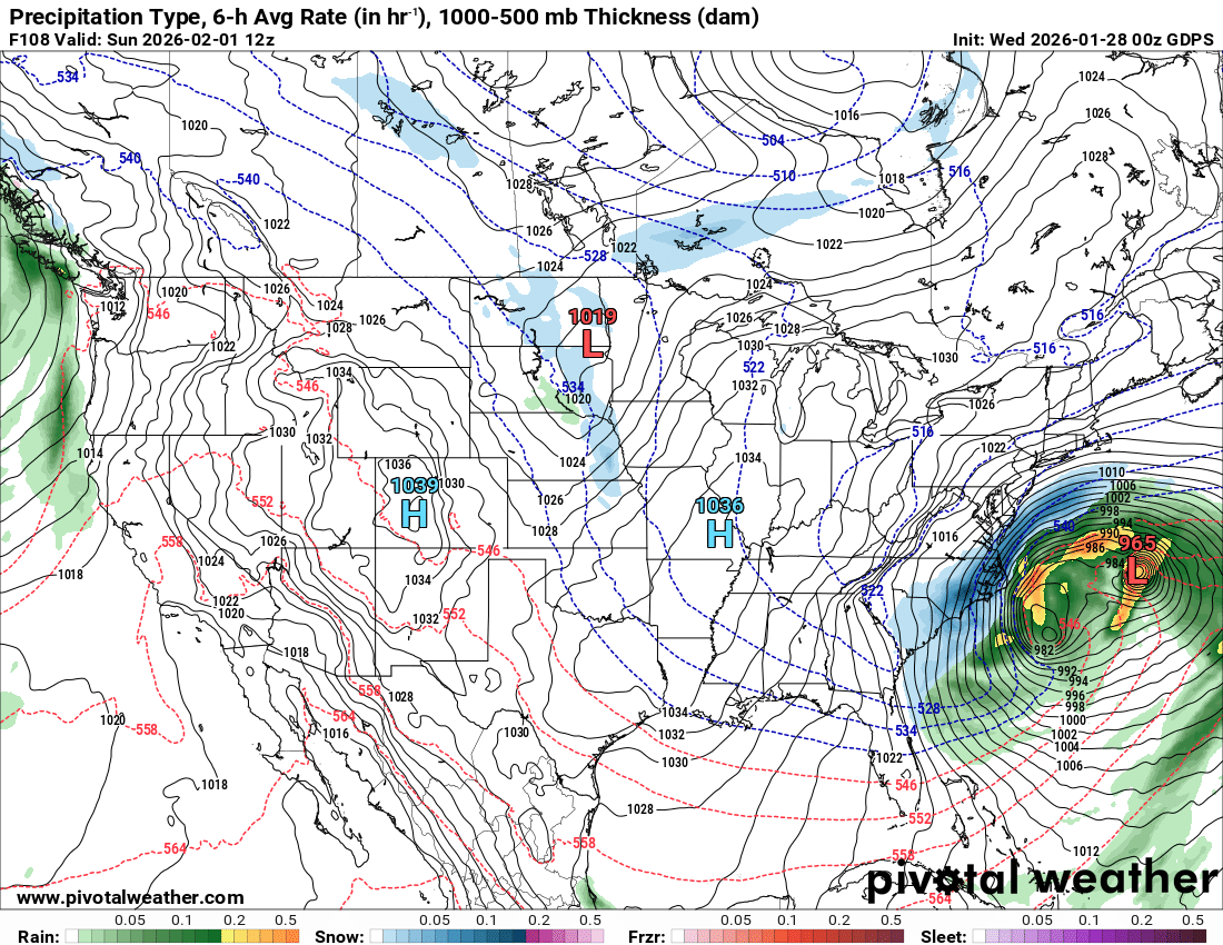
If you run this 500mb vort prog in motion you can see around the Great Lakes the trough pushing a ridge overtop that's shoving our system SE. I think this is fairly representative of all the models. https://www.tropicaltidbits.com/analysis/models/?model=namconus®ion=us&pkg=z500_vort&runtime=2026012812&fh=1 -
The Jan 31 Potential: Stormtracker Failure or 'Tracker Trouncing
mitchnick replied to stormtracker's topic in Mid Atlantic
Yeah...you still rub me the wrong way though! -
The Jan 31 Potential: Stormtracker Failure or 'Tracker Trouncing
mitchnick replied to stormtracker's topic in Mid Atlantic
In northern AA County, every once and a while little would would start to fall steadily, then dwindle to flurries, only to rub salt in the wound. -
The Jan 31 Potential: Stormtracker Failure or 'Tracker Trouncing
mitchnick replied to stormtracker's topic in Mid Atlantic
And therein lies the rub. -
The Jan 31 Potential: Stormtracker Failure or 'Tracker Trouncing
mitchnick replied to stormtracker's topic in Mid Atlantic
For those of us west of the Bay, Boxing day was even closer than what is depicted here. -
The Jan 31 Potential: Stormtracker Failure or 'Tracker Trouncing
mitchnick replied to stormtracker's topic in Mid Atlantic
Fwiw, if you compare 0z Nam to 6z, you can see that it took has taken on the precip shield as Gfs and Euro at 84hrs vs the "headed north" look of 0z. -
The Jan 31 Potential: Stormtracker Failure or 'Tracker Trouncing
mitchnick replied to stormtracker's topic in Mid Atlantic
This has had Boston's name all over it from the start with the way it extends east. -
The Jan 31 Potential: Stormtracker Failure or 'Tracker Trouncing
mitchnick replied to stormtracker's topic in Mid Atlantic
Here comes the northern stream energy to kick it east. -
The Jan 31 Potential: Stormtracker Failure or 'Tracker Trouncing
mitchnick replied to stormtracker's topic in Mid Atlantic
That's snow depth measuring what's already on the ground that isn't melting. -
The Jan 31 Potential: Stormtracker Failure or 'Tracker Trouncing
mitchnick replied to stormtracker's topic in Mid Atlantic
Just like the Gem, it's got the northern stream system coming out of the Dakotas. Gfs has essentially nothing of consequences on the map. -
The Jan 31 Potential: Stormtracker Failure or 'Tracker Trouncing
mitchnick replied to stormtracker's topic in Mid Atlantic
Could see it coming. That kicker in the upper Midwest came flying south out of Canada.
-
The Jan 31 Potential: Stormtracker Failure or 'Tracker Trouncing
mitchnick replied to stormtracker's topic in Mid Atlantic
Watch out for that kicker on the Gem. -
The Jan 31 Potential: Stormtracker Failure or 'Tracker Trouncing
mitchnick replied to stormtracker's topic in Mid Atlantic
Not quite as good 0z. -
Surface looks "busy." https://meteocentre.com/numerical-weather-prediction/map-explorer.php?lang=en&map=na&run=18&mod=cmc_gdps&stn=PNMPR&comp=1&run2=18&mod2=cmc_gdps&stn2=PNMPR&hh2=000&fixhh=1&stn2_type=prog&mode=latest&yyyy=latest&mm=latest&dd=latest&hh=084
-
18Z GGEM https://meteocentre.com/numerical-weather-prediction/map-explorer.php?lang=en&map=na&run=18&mod=cmc_gdps&stn=PNM&comp=1&run2=18&mod2=cmc_gdps&stn2=PNM&hh2=000&fixhh=1&stn2_type=prog&mode=latest&yyyy=latest&mm=latest&dd=latest&hh=084
-
Actually, cut snowfall in half from 12z for mby, BWI, DCA and even SBY.
-