

mitchnick
-
Posts
27,049 -
Joined
Content Type
Profiles
Blogs
Forums
American Weather
Media Demo
Store
Gallery
Everything posted by mitchnick
-
Eps snowfall on day 14, which obviously includes 13, is attsched. Nothing of consequence. Pure scattering of nothing.
-
Might as well pile on with the bad news. I also said the stronger ridge to the east would warm things up than thought. Top map is 12z and bottom map 18z.
-
Ughh. Just what I feared. My earlier post mentioned that the ensembles, especially the Eps and Geps, had a broad, oval ridge out west poking into the TN Valley approaching the MA, fearing it would suppress precip. Well, like clockwork, the 18z Gefs succumb to the Eps and Gefs. The top 2 maps are off the 12z with the 5H anomalies and 6-hour precip at the end of the run. Bottom 2 are off the 18z for the same time as 12z. Look how the ridge in the west is now stronger and pushing much further east and looks a lot like the 12z Eps and Geps (assuming you bothered to look at them.) Now look at the precip map...weaker and much further south thanks to the pancake ridge blocking the flow from the Gulf of Mexico. It's cr@p like this that is absolutely maddening because those "perfect" maps, at least in recent years, continue to degrade ascwe approach crunch time. And before some knucklehead jumps in and claims it, it has nothing to do with CC. It's just lousy modeling and even worse luck than was thought possible. Now this doesn't mean I am saying no change to cold or that this can't morph into something good or great past current models runs. I am saying, however, don't trust any model that shows a snowy or perfect pattern no matter how certain or clear it looks to be on modeling.
-
Where's that?
-
I edited the above post as I mistakenly posted n/s trough instead of ridge.
-
I'm sorry, I do not like at all that broad, oval ridge in the west that's poking itself into the TN Valley approaching the Mid Atlantic, most pronounced on the Eps and Geps, less so on the Gefs. If that keeps expanding (go look at all 3 ensembles days 12 to end), that will suppress southern systems imho and eventually provide a warmup before the next uneventful cold front moves south. I certainly hope I'm wrong, but it will throw a monkey wrench into our pattern vs a needed n/s oriented ridge.
-
It was a Flop... February 2024 Disco. Thread
mitchnick replied to Prismshine Productions's topic in New England
Bwi reported 28.2" over a 4 day period. The controversy was whether it was correct to report as one storm the snow that fell Friday night thru and including Monday as there 2 lulls. I remember getting into an argument with somebody on Usenet (I think) from NE who called me a liar when I gave the total. He was around 20 and he said BWI can't get much snow ever because he just figured our 9" in 00/01 and 4" in 01/02 was climo. Young punk! Lol -
It was a Flop... February 2024 Disco. Thread
mitchnick replied to Prismshine Productions's topic in New England
PDI was great at BWI too. Woke up at 3am to 2-3"/hr. Ended with 18-19". -
It was a Flop... February 2024 Disco. Thread
mitchnick replied to Prismshine Productions's topic in New England
As you should know, the cause for the warming has been the current MJO wave. It's been on the models for at least 8 days as evidenced by the attached Eps 850 wind anomaly forecast from 1/25. It's been on the models longer than that, but I don't have anything else handy to attach. And considering the Eps have been showing the upcoming pattern change since before 1/25, I think it's fair to say the models have figured it into their forecasts. So to quote a well-respected wx enthusiast, "no changes." Moreover, it's the strong MJO wave that's prompting the threat of a SSW. After this equatorial warming event, the Niño is toast.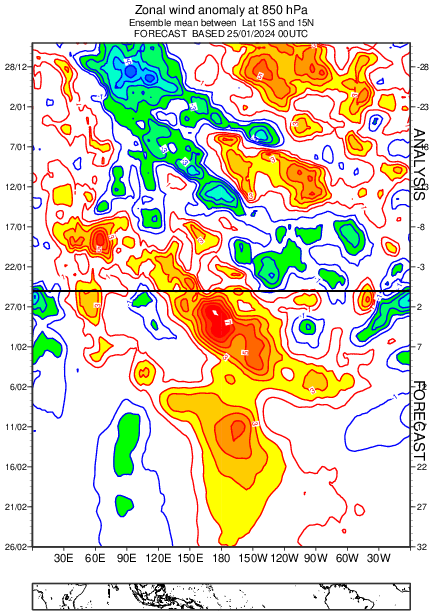
-
It was a Flop... February 2024 Disco. Thread
mitchnick replied to Prismshine Productions's topic in New England
-
It was a Flop... February 2024 Disco. Thread
mitchnick replied to Prismshine Productions's topic in New England
Once cold is established by the Eps, these are the next 3 weeks' precip anomalies starting with week ending 2/26 off yesterday's run. -
Thanks for the reminder. I remember the day when old people were a protected class...sonny.
-
Can't believe they filmed me without my consent.
-
Is it just as green on your side of the fence?
-
My concern is precip. All long range guidance I've seen shows a great trough in the east, +PNA, -NAO and dry. I believe it gets cold, but does it precipitate? I don't think we can just assume the stj continues to aim precip at us since the whole pattern will be changed from what we've had and looks stable thru early March. I'm not forecasting it will be dry, but nothing I've seen has AN precip for us and some guidance is well BN precip. Always something.
-
Screw em?....a tiny moth? You been talking to my wife?
-
Moths need a home too ya' know.
-
The fact that there are 3, if not more, sources for ssta numbers is absurd imho.
-
There is support!
-
Only if you promise to never post climo data. Lol
-
The sacred "pattern" advertised by long range modeling for weeks has medium range modeling advertising the "fruits" of the pattern now within the medium range.
-
Crushes it instead of phasing. Carry on...nothing to see here. Lol
-
Fwiw, Canadian looks a bit more interesting with the 5th early on with the northern stream headed SE. How much it can pull the southern stream north tbd.
-
They got one a couple weeks before PDII.
-
Doubt it's right, but 0z Icon is entertaining if nothing else.


