

mitchnick
-
Posts
28,569 -
Joined
Content Type
Profiles
Blogs
Forums
American Weather
Media Demo
Store
Gallery
Everything posted by mitchnick
-
It'll drift south over the coming days.
-
Central PA Spring 2026 Discussion/Obs Thread
mitchnick replied to Voyager's topic in Upstate New York/Pennsylvania
Euro lost the threat, but it's AI cousin has it. -
Central PA Spring 2026 Discussion/Obs Thread
mitchnick replied to Voyager's topic in Upstate New York/Pennsylvania
I was through your quaint little town yesterday. I got rear-ended in York last week with $11K+ in damages. At first the insurance company was going to pay to repair but more work was probably needed so they totalled it. Not happy. Anyway, near identical car to mine was for sale at a dealer in Selinsgrove, so I went up there and got it. Accidents suck, but fortunately my wife and I weren't hurt because the jeep that hit us slid above the bumper and crinkled the body lessening the impact, but causing more damage. I gotta shlep up there next week to pick it up and pay. I'll wave as I come through. -
All 3 ensemble snowfall forecasts are pretty decent for any time of the year, and especially for mid March. The only issue for consideration is that the ensembles are 10:1 and Kuchera on the operationals is less than 10:1 in varying degrees depending on surface temps.
-
2026-2027 El Nino
mitchnick replied to Stormchaserchuck1's topic in Weather Forecasting and Discussion
Nobody and no model can accurately predict the strength of Niños or Niñas the first week of March for the following winter. Anything to try to be the first and for clicks. -
Outta gas and Outta Time: Early March Winter Storm finale
mitchnick replied to Ji's topic in Mid Atlantic
In a little town of Aldie no doubt? Lol -
That week is probably our last legit shot until next year.
-
You could say today's Euro weeklies cooled down a bit starting week 3. Lol https://charts.ecmwf.int/products/extended-anomaly-2t?base_time=202603020000&projection=opencharts_north_america&valid_time=202603230000 It ain't over until we say it is!
-
Click bait in the sense it's sensationalized. I know Webb is legit, but the need for clicks is never ending it seems.
-
Too early to declare strength of Niño imho. Just click bait.
-
2026-2027 El Nino
mitchnick replied to Stormchaserchuck1's topic in Weather Forecasting and Discussion
Don't know where to put this, but here it is. New Cansips pretty sweet for next year. This is a link to December, 2026. Scrolling thru to February shows lots of blocking. https://www.tropicaltidbits.com/analysis/models/?model=cansips®ion=nhem&pkg=z500a&runtime=2026030100&fh=9 Here's a link to SSTA map starting December. Looks solid moderate Niño. https://www.tropicaltidbits.com/analysis/models/?model=cansips®ion=global&pkg=ssta_noice&runtime=2026030100&fh=9 Here's a link to surface temps starting December. https://www.tropicaltidbits.com/analysis/models/?model=cansips®ion=eus&pkg=T2ma&runtime=2026030100&fh=9 Here's a link to precip starting December. https://www.tropicaltidbits.com/analysis/models/?model=cansips®ion=eus&pkg=apcpna_month&runtime=2026030100&fh=9 -
Yeah, I screwed up putting it inbthus thread. I'll delete my post here and repost it. Then your post will make better sense.
-
Don't know where to put this, but here it is. New Cansips pretty sweet for next year. This is a link to December, 2026. Scrolling thru to February shows lots of blocking. https://www.tropicaltidbits.com/analysis/models/?model=cansips®ion=nhem&pkg=z500a&runtime=2026030100&fh=9 Here's a link to SSTA map starting December. Looks solid moderate Niño. https://www.tropicaltidbits.com/analysis/models/?model=cansips®ion=global&pkg=ssta_noice&runtime=2026030100&fh=9 Here's a link to surface temps starting December. https://www.tropicaltidbits.com/analysis/models/?model=cansips®ion=eus&pkg=T2ma&runtime=2026030100&fh=9 Here's a link to precip starting December. https://www.tropicaltidbits.com/analysis/models/?model=cansips®ion=eus&pkg=apcpna_month&runtime=2026030100&fh=9
-
*MOVED TO NINO 26/27 THREAD* New cansips pretty sweet for next year.
-
Beautiful day for a ride to York and get rear-ended big time.
-
Geps big time, with a developing-NAO.
.thumb.png.37a0f4097ec5aa32f8506a3b98931c8e.png)
-
The same model that a few days ago gave me 15" on Monday? Ok
-
So sue me!
-
Looked and felt like a real winter, but definitely not enough snowfall.
-
This is what I've been thinking too. But NE will, of course, be favored. Plus, we've had how many BN months in a row? Has to change at some point, but I'm not sure a fading Niña will do it.
-
Euro does have cold looming to our NW at the end of its run. Whether it gets to us is the question.
.thumb.png.b4978c8828e9c5f25306749e7e5e2e0a.png)
-
Absolutely...but whether it'll be in my lifetime is all I care about.
-
30 and freezing fog imby. York Airport, notoriously cold with its temp gauge in a low spot, at 22 degrees with freezing fog. They are right on Rt. 30 with a speed limit around 50mph. Wouldn't want to be driving there this morning.
-
Outta gas and Outta Time: Early March Winter Storm finale
mitchnick replied to Ji's topic in Mid Atlantic
I know it's not much, but Eps came around 30 miles south from 12z. Modest as it is, there still is plenty of time with this.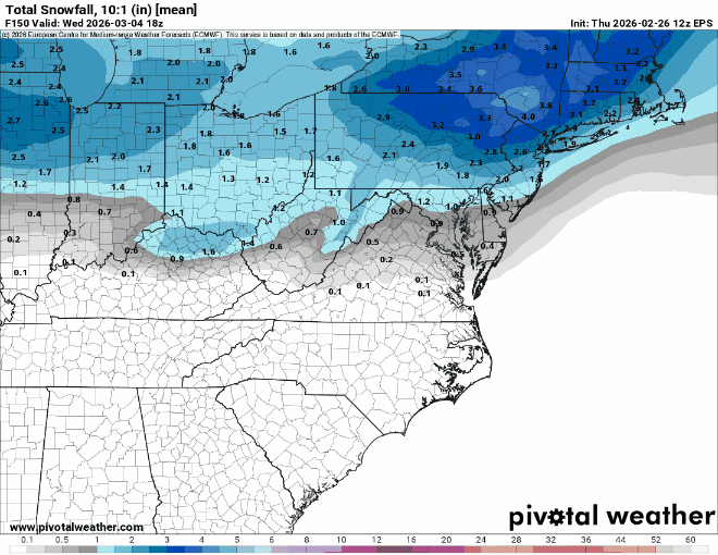
-
Oh no...I guess I'll be stuck just scratching dry skin.


.png.7110388d608c7fff5ffa8fe0f9860aa5.png)

.png.9cebcdc04f6570bcdc49969db92373d9.png)