mitchnick
-
Posts
28,735 -
Joined
Content Type
Profiles
Blogs
Forums
American Weather
Media Demo
Store
Gallery
Everything posted by mitchnick
-
2026-2027 Super El Nino
mitchnick replied to Stormchaserchuck1's topic in Weather Forecasting and Discussion
Yes, but the real chances, if they come, would likely be in the 1/15-3/15 period. Barring a miracle, December will likely disappoint if you're looking for snow outside of the higher elevations imho. -
2026-2027 Super El Nino
mitchnick replied to Stormchaserchuck1's topic in Weather Forecasting and Discussion
Which, according to Usetobe (retired met from LWX), is exactly where we want it (just east of the DL) come winter. Can the mean forcing hold there come winter is, course, the question. We'll see. -
That's because going east would put them over Stephens City, VA!!
-
Updated July NMME holds June forecast in the east except for slightly warmer in NNE and cooler in the SE for December-February. Precip AN in the east again with an increased shield and rate over June forecast. Monthly temp forecast beginning December. https://www.tropicaltidbits.com/analysis/models/?model=nmme®ion=us&pkg=T2ma_nmme&runtime=2026070800&fh=5
-
2026-2027 Super El Nino
mitchnick replied to Stormchaserchuck1's topic in Weather Forecasting and Discussion
Updated July NMME holds June forecast in the east except for slightly warmer in NNE and cooler in the SE (Congrats Larry!) for December-February. Precip AN in the east again with an increased shield and rate over June forecast. Monthly temp link starting December: https://www.tropicaltidbits.com/analysis/models/?model=nmme®ion=us&pkg=T2ma_nmme&runtime=2026070800&fh=5 -
2026-2027 Super El Nino
mitchnick replied to Stormchaserchuck1's topic in Weather Forecasting and Discussion
Where'd that come from? Lol Just be happy with the 1-2C+ the Euro is showing for the NE and hope for warmer next time. -
2026-2027 Super El Nino
mitchnick replied to Stormchaserchuck1's topic in Weather Forecasting and Discussion
Come on man. Google is your friend. Lol -
2026-2027 Super El Nino
mitchnick replied to Stormchaserchuck1's topic in Weather Forecasting and Discussion
Like I said, I agree seasonal models are generally inaccurate. We know this. But using a model prog from 3 years ago as a basis has no relevance especially considering upgrades have been made and without statistical proof that the current version has particular biases in Niños. And since there have been no Niños since 2023, that ain't happening. -
2026-2027 Super El Nino
mitchnick replied to Stormchaserchuck1's topic in Weather Forecasting and Discussion
From my recollection, you comment on seasonal models as much as everyone else. If you want to say commenting doesn't have anthing to do with belief in them, then ok. But I don't think anyonevon this Board believes seasonal modeling is gospel, especially at 5+ months. You misunderstand the surrogate intent and obviously deflect. -
2026-2027 Super El Nino
mitchnick replied to Stormchaserchuck1's topic in Weather Forecasting and Discussion
Then why use older temp forecasts to argue for warmer conditions? Be honest. If the Euro came in this month, or does in future months, that the NE will be a torch this winter, I suspect you, or one of your surrogates, will be all over it. -
2026-2027 Super El Nino
mitchnick replied to Stormchaserchuck1's topic in Weather Forecasting and Discussion
If your point is that seasonal models are generally inaccurate, I agree. But they do offer guidance and leave it up to pros and weenies to put whatever weight they choose. But what we're seeing this year so far is a "rough" consensus similar to this month's Euro. At this point, that consensus is encouraging unless one is hoping for a national/worldwide torch. -
2026-2027 Super El Nino
mitchnick replied to Stormchaserchuck1's topic in Weather Forecasting and Discussion
And don't forget that the last 2 winters the Euro seasonal was too warm in the NE. And since it is impossible to have statistical data that supports the notion that the current Euro seasonal is inherently biased too cool for Niños in its current upgraded version (and I don't see that being possible since there have been upgrades since the 2023 season), I honestly don't see the relevance of prior year forecasts. All we can take away, imho, is that the Euro seasonal has been inaccurate with its winter temp forecasts in the NE 3 out of the last 3 years, twice being too warm and once being too cool. Edit: And let's not forget this month's forecast looks very similar to other seasonal modeling. -
Just a WAG, but I think this week marks the beginning of a transition to legit Niño conditions i.e. wetter and cooler than normal. We'll see.
-
2026-2027 Super El Nino
mitchnick replied to Stormchaserchuck1's topic in Weather Forecasting and Discussion
Just a WAG, but I'd day there's a 5-10% chance the winter (DJF) north of MD/PA border will average BN, but a 50/50 chance 1 month could end up BN with February being the best chance. Fwiw, I think March has a 60-70% chance of BN, though only slightly. -
Same here in Hanover and 1.28" at York airport 8-9 miles to my ENE. 6." Saturday night.
-
Getting crushed in Hanover. Yay...I'll get to mow sooner.
-
2026-2027 Super El Nino
mitchnick replied to Stormchaserchuck1's topic in Weather Forecasting and Discussion
Individual monthly December and January Euro seasonal maps courtesy Weather Will in the MA forum. https://www.americanwx.com/bb/topic/62735-winter-2026-2027-historic-potential/?do=findComment&comment=8107554 -
Get that ridge max in SE Canada 100 miles further north than progged and we'll be fat city.
-
2026-2027 Super El Nino
mitchnick replied to Stormchaserchuck1's topic in Weather Forecasting and Discussion
Surprisingly, Euro seasonal still not very impressed with ACE forecast.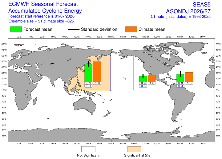
-
New Euro seasonal has potential written all over it. Very wet with coastal storms clearly favored. Temps look to cooperate (only a little AN Nov-Jan) more than one may have thought with s Niño as strong as advertised. Here's a link to the free parameters. Unfortunately, they only go out to January, but if what it's showing holds for next month's forecast, Feb (March too?) should be rockin'. https://charts.ecmwf.int/?facets={"Product type"%3A["Experimental%3A AIFS"]%2C"Parameters"%3A[]%2C"Type"%3A[]%2C"Range"%3A["Seasonal"]} How's this for a mean Surface pressure Nov-Jan?
-
2026-2027 Super El Nino
mitchnick replied to Stormchaserchuck1's topic in Weather Forecasting and Discussion
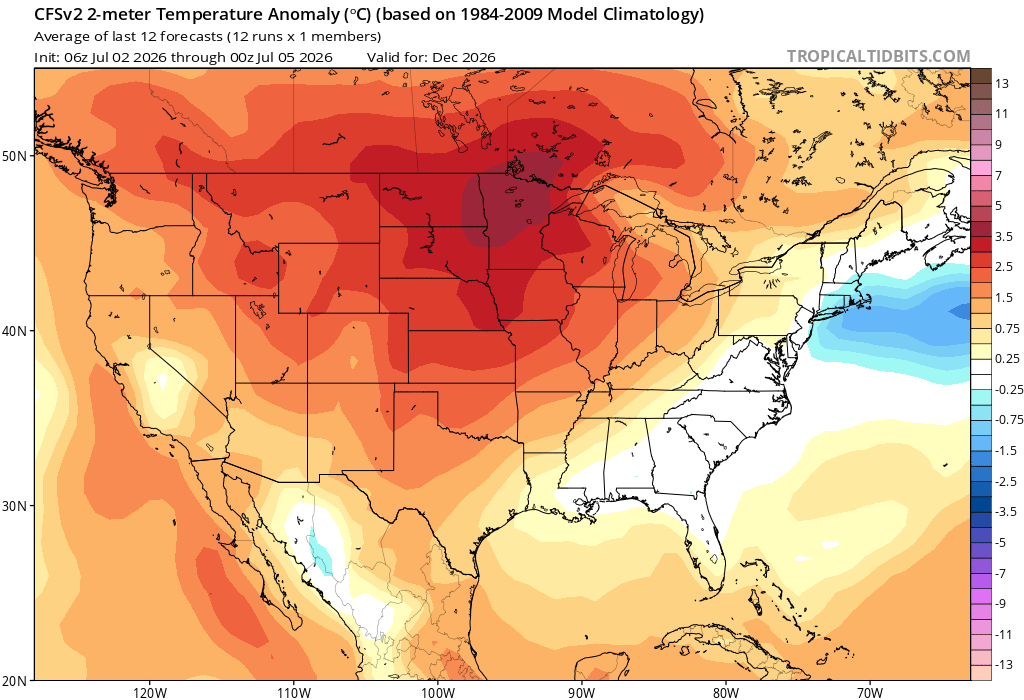
I started to say I agree, but I just couldn't get myself to do it. Lol j/k So, the latest Cfs2 for December! Lol
-
2026-2027 Super El Nino
mitchnick replied to Stormchaserchuck1's topic in Weather Forecasting and Discussion
Couldn't agree more. It tells me that the other seasonal models aren't far off with their progs of a winter offering legit chances for snow and cold, obviously interspersed with AN periods that will push the mean to only a little AN. Of course, without seeing the monthly maps, there's a but of speculation on my part. -
2026-2027 Super El Nino
mitchnick replied to Stormchaserchuck1's topic in Weather Forecasting and Discussion
Euro seasonal temps and precip thru January don't look bad to me in the east. Very wet with surface temps dropping as we head into winter. I bet February would look great, but the free maps stop at January. H5 looks reasonably tasty too imho. Naysayers, have at it. Lol Link to free parameters. https://charts.ecmwf.int/?facets={"Product type"%3A["Experimental%3A AIFS"]%2C"Parameters"%3A[]%2C"Type"%3A[]%2C"Range"%3A["Seasonal"]} -
I thought this whole thread was a fallacy! Lol
-
2026-2027 Super El Nino
mitchnick replied to Stormchaserchuck1's topic in Weather Forecasting and Discussion
Now you've done it. Just wait for all those 246hr Gfs snowstorm maps this winter from us weenies.