TheDreamTraveler
Members-
Posts
880 -
Joined
-
Last visited
Content Type
Profiles
Blogs
Forums
American Weather
Media Demo
Store
Gallery
Everything posted by TheDreamTraveler
-
Bigger hurricanes aren't always more immune to negative environmental factors. Sometimes it can be a detriment to their health allowing them to suck in more dry air and experience shear just due to how big they are. Smaller hurricanes can sometimes weasel their ways into smaller more favorable pocketed environments if they're lucky enough.
-
The GFS is just insistent on Milton striking a bit north of Tampa. Every run has had it either north or striking directly so far.
-
The west coast of Florida just can't catch a break the past 3 years with Ian, Idalia, Helene and now Milton. Though Idalia was definitely a lot weaker than people originally thought at landfall at least. I wouldn't bank on any sure intensity ideas until we're a day or two from landfall. Hurricane intensity is the hardest part of forecasting a hurricane.
-
Of course they're only going to go to 155mph lol. Would be pretty wild to see two category 5's this year. Beryl being the earliest that far east and Kirk being the strongest this far east this late in the season
-
2024 Atlantic Hurricane Season
TheDreamTraveler replied to Stormchaserchuck1's topic in Tropical Headquarters
The GFS sure seems adamant on another hurricane landfalling in the same location as Helene multiple runs in a row. Would be absolutely awful if it ends up anywhere close to there. Then take into account Idalia hitting near that same area last year? Crazy. -
Basically the worst case scenario is unfolding and we still have a few more hours to go.
-
-
I feel like people forget that Helene will still be a strong storm just due to its monster size. Hurricane Ike looked like was a lot 'weaker' when it made landfall but it caused much more damage just due to its huge size compared to a smaller storm of its strength. Helene will be more destructive than a typical smaller hurricane at this category. Just because the wind speeds aren't super high the low pressure and large size/wind field are going to cause much more damage. I feel like people focus way too much on the max wind speed and what category the storm is when there's more that factor into its power and damage overall.
-
The wind field on this thing is absolutely massive. This thing is gonna be a beast in size once it gets built up.
-
2024 Atlantic Hurricane Season
TheDreamTraveler replied to Stormchaserchuck1's topic in Tropical Headquarters
When was the last time we saw a September this inactive, 2014? We still have half of the month to go but things aren't looking too good. Still could change come end of September into October but I'm really starting to doubt a sudden uptick happening anymore -
2024 Atlantic Hurricane Season
TheDreamTraveler replied to Stormchaserchuck1's topic in Tropical Headquarters
Definitely one of the more interesting seasons we've had in a long time. A record breaking category 5 at the beginning of July that smashed basically every single record known to us and then...nothing. Even into the peak of the season where we were forecast to have a very hyperactive season. I'd love to know all the ins and outs in depth of why this is happening. I've read some thoughts on it but I'm sure there's more things. I swear I see people say "oh the waters are warm its gonna be active!!" even though you can have a dead season with record warm waters if other factors don't line up. The atlantic hurricane mechanisms are very deep and varied. -
2024 Atlantic Hurricane Season
TheDreamTraveler replied to Stormchaserchuck1's topic in Tropical Headquarters
It wouldn't be hurricane season without him cancelling the season before it even really starts. -
2024 Atlantic Hurricane Season
TheDreamTraveler replied to Stormchaserchuck1's topic in Tropical Headquarters
These are the same type of people that declare a season dead by the end of July when most storms don't even start forming until mid-late August. The season is not supposed to be super active right now even in a very hyperactive season. They look at the models showing nothing for weeks and declare it dead every single year. It's like people forget seasons can ramp up massively in August. -
2024 Atlantic Hurricane Season
TheDreamTraveler replied to Stormchaserchuck1's topic in Tropical Headquarters
Even the hyperactive record breaking seasons of 2020 and 2021 didn't have what's trying to happen right now with a major hurricane and another trying to form right behind it this far east heading into the Caribbean at the same time in late June/early July. This definitely provokes 2005 and a little bit of 1933 which were massive anomalies. Maybe the ECMWF wasn't hallucinating when it was predicting the most active hurricane season ever since it first went online back in the early 90s -
Central PA Winter 23/24
TheDreamTraveler replied to Voyager's topic in Upstate New York/Pennsylvania
They gave me that exact same time estimation when my power went out a few hours ago. Hoping yours comes back sooner than later. -
Central PA Winter 23/24
TheDreamTraveler replied to Voyager's topic in Upstate New York/Pennsylvania
Lost power here for an hour. Had it flickering off and on repeatedly and I kept hearing a electrical buzzing outside each time it happened. Thank god it came back on just now I was ready for it to be out for a while lol. That snow looks heavy af -
Central PA Winter 23/24
TheDreamTraveler replied to Voyager's topic in Upstate New York/Pennsylvania
You doing okay? -
Central PA Winter 23/24
TheDreamTraveler replied to Voyager's topic in Upstate New York/Pennsylvania
Got a little bit of snow cover here but it's melting really fast. Cars covered and some of the grass is covered. -
Central PA Autumn 2023
TheDreamTraveler replied to Itstrainingtime's topic in Upstate New York/Pennsylvania
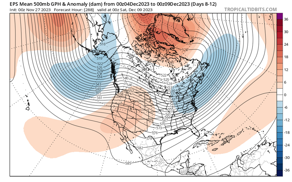
Maybe we'll luck out with some snow 2nd week in December? Still hard to know this far out but the chance of some colder than average temperatures might be on the menu -
Central PA Autumn 2023
TheDreamTraveler replied to Itstrainingtime's topic in Upstate New York/Pennsylvania
Maybe I'm dumb but isn't that a good thing for snow chances? lmao. Literally why I posted it here since there's so much doom and gloom about this winter from some -
Central PA Autumn 2023
TheDreamTraveler replied to Itstrainingtime's topic in Upstate New York/Pennsylvania
Some slightly good snow news for winter potentially -
Central PA Autumn 2023
TheDreamTraveler replied to Itstrainingtime's topic in Upstate New York/Pennsylvania
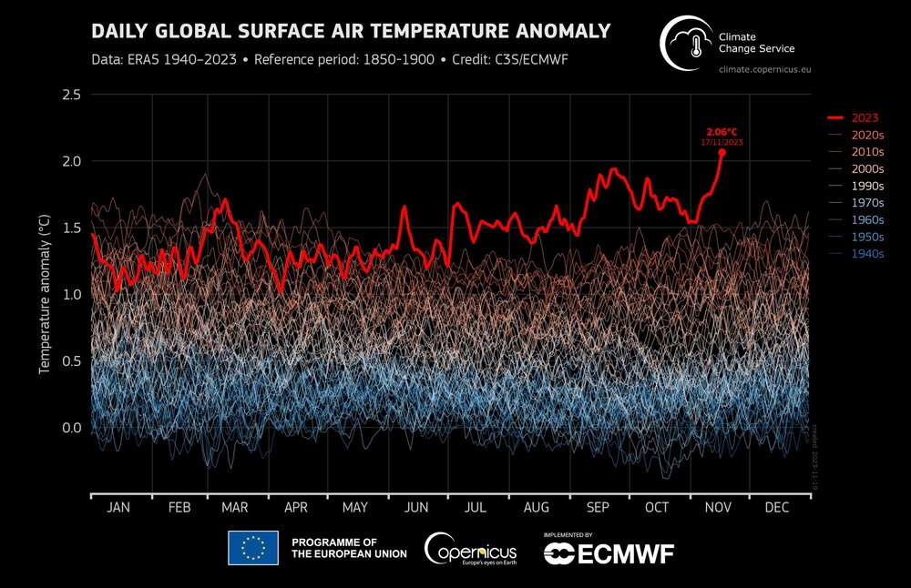
If you're wondering why I don't see us getting much snow again this year this is why. Obviously there are still parts of the globe that are colder than average but this has been an unprecedented increase in global temps since June. I was really curious if this insane heat would survive until winter and well...looks like it still is. This only serves to reduce our chances of getting snow this winter. Not that we CAN'T get lots of snow this winter it's just all the extra heat really throws a wrench into our normal chances. I legitimately thought the insanely hot temps would have gone back down by now but it hasn't. Obviously things depend on local weather patterns and how storms and cold air align. My main point here is this type of global heat just reduces snow chances for many places. Maybe we'll luck out this year who knows. Oh and the most mindblowing part about this heat? Most of this heat hasn't had much of an impact from the El Nino yet. The lag period we'll eventually feel from the heat globally from El Nino won't happen until 2024 lol so it's only going to get hotter -
Central PA Autumn 2023
TheDreamTraveler replied to Itstrainingtime's topic in Upstate New York/Pennsylvania
25 here right now. Waaay too chilly for me for November lol -
Central PA Autumn 2023
TheDreamTraveler replied to Itstrainingtime's topic in Upstate New York/Pennsylvania
Every generation always says that about the previous generation and we usually end up fine lol. Also Twitter sustains itself off of negative reactions and outrage which is why the site always pushes things to people that make them mad or upset since it makes the most money. It also helps create this false perspective of how the real world really is hence the intense polarization that has developed over the years. I started using the site years ago and only recently noticed just how much mental harm it had done to me recently which is true of almost all social media. Seriously that site is so bad for your mental health if you don't know how to curate things and stay away from the unhealthy stuff. Especially after Musk's blunder buying the site the amount of misinformation and disinformation is the worst I have ever seen it to the point I actively stay away from all trending tabs now. And that doesn't even scratch the service of the site being flooded with so many AI bots that are now so real it is practically impossible to tell who's real or fake on that site anymore leading to malicious folks having immense power to manipulate society however they see fit. My point is social media is bad for you lol -
Central PA Autumn 2023
TheDreamTraveler replied to Itstrainingtime's topic in Upstate New York/Pennsylvania
Already 61 today. Another beautiful autumn day


