

Heisy
-
Posts
8,369 -
Joined
-
Last visited
Content Type
Profiles
Blogs
Forums
American Weather
Media Demo
Store
Gallery
Posts posted by Heisy
-
-
Nice trend with 6z euro. Much sharper shortwave. This is a nice surprise let’s keep it going at 12z
-
 1
1
-
-
5 hours ago, Newman said:
The threat to watch out for is around Feb 13-15. @Wentzadelphia, take a look at the Para-GFS. It tries to pull a 96' with the vortex escaping into the 50/50 region, and a PNA spike bringing down another piece of energy that closes off in the center of the country. The only problem with this 12z run was it amps up way too early. Regardless, I'm on board with your February 10-17 call. It'll likely be centered around the 14th or 15th..


Yep I’ll be hyping this up until it fails, but 18z gfs pretty much progressed exactly how I’ve been talking about. Hope eps starts honing in next few days. We always have our opportunity for big ones after block has fully retrograded and tpv moves east into 50/50 region
-
2 minutes ago, Stormfly said:
1994, remember that well too! Burned through about half of my vacation time because it was impossible to get up the hill from our home!
Lots of ice, rain on top of snow, froze solid, snow on top of it. Felt sorry for anyone that had to dig, even the big excavators couldn't move around. And if you fell on a slight incline, better hold on because you were going all the way down! Lots of humming at night, eerie blue-green flashes all around and poof! Spending lots of my younger times at sea I was accustomed to the humming of two stroke diesels so I had no problem sleeping during the long outages. I do prefer the throb of the prime movers though and pity those depending on 3600 rpm natural gas gennies to keep their freezers humming in the south when the big canes tear the overheads down as far as the eye can see.
1977, lived just outside of the beltway (between Carney and Parkville) and remember the freezing over of the inner harbor and Chesapeake Bay! Holy Moly if there is a winter that could be called a mini ice age that was it! People were driving across the harbor!
In April we went down to our beach home on Nabbs Creek to be greeted by ice over 5" thick! The air bubblers weren't able to keep up and the dock was in moderately poor shape with lots of heaved pilings.I was only 8 years old but I remember missing a lot of school & ice skating ON THE GRASS with my mom in our backyard up in Philly hah. Which is crazy if you think about in today’s climo
-
2
-
-
51 minutes ago, psuhoffman said:
just messing with ya, it was a good piece of pattern recognition by you. I agree that there is an elevated threat of a storm there
You can see the nice trend on the eps today as well. Hopefully we see eps start honing in on it more over the next few days. Gfs also had that quick spike in the pna which allowed that wave to dig as far as it did. Seeing slightly better pna ridging today hopefully that continues. HA event potentially. That 50/50 region is hawt. Just need spacing to work out


-
I love how the 18z gfs formed a storm at day 10-11 in the exact same way I’ve been talking about
")
-
1 hour ago, Amped said:

Thanks SE ridge
That’s the risk with AO blocks retrograding west. Forces ULL sit west of lakes which increases ridging on the EC. Then you get HP off the EC. You have to hope the ULL is strong enough to get the gradient south enough
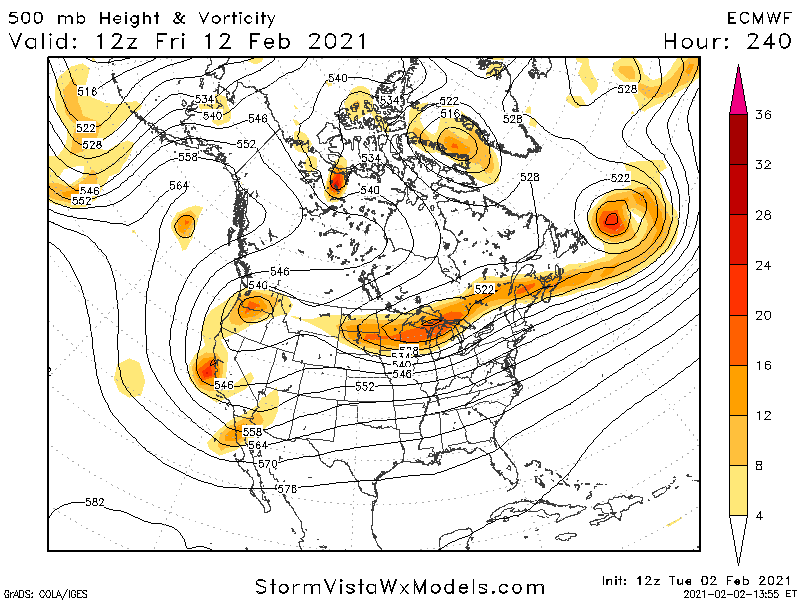
This is why I’m more excited in the Day 10+ time frame. Look at end of euro run you have an elongated PV in 50/50 location with confluence draped behind it. A rising PNA. If a shortwave can form between the two it’s a perfect setup * note the HP sitting in a great spot at the end of the run.
im still not dismissing anything until then I just like the potential towards feb 11-17 more
-
3
-
-
1 minute ago, MJO812 said:
Eps shows a Miller b next weekend
Problem is the Tpv is west of lakes this will make it tough for any low to track south of NYC. Think the gradient will be very close to NYC though but I’d favor SNE and NNE right now. Looks more like a SWFE to me. HP is not in an idea location because of the ULL positioning.
-
1
-
-
Been hyping it, but IMO it’s after the block is done retrograding and low heights head into 50/50 region that I think a big event is possible. Look at the end of the euro run. Elongated tpv with HP behind it. PNA ridge building, if any wave in between there is strong enough it would be perfect
-
2
-
-
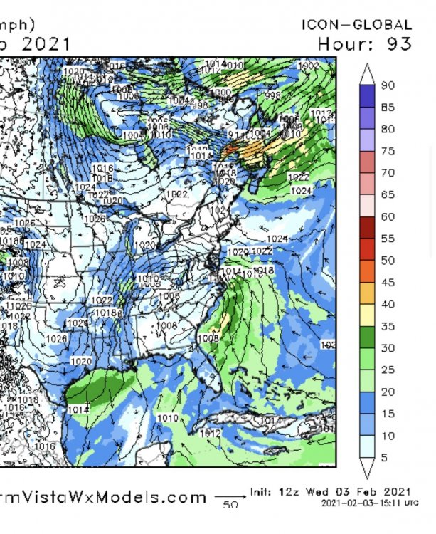
Icon continues having a strong low for Sunday.
-
1
-
-
Icon brings the LP sub 980 on the gulf of Maine
-
12z icon looks amped again
-
1
-
-
Just now, MJO812 said:
Yes you do
Weenies care about snow
Wouldn’t sweat it, if Sunday fails a few days later there’s a threat, and it’ll continue for a few weeks.
-
38 minutes ago, CoastalWx said:
GFS made a better move. Definitely still in play. EPS mean had some hints of it.
Should be many threats as the tpv keeps rotating south under the block, just need a little luck with the configuration.
-
1 hour ago, RedSky said:
I will investigate tomorrow an inquiry to be launched
It’s not impossible though, where I was in NJ a band parked itself on me. I was literally probably 10 miles away from being too far S

-
1
-
-
It’s still snowing outside NE Philly, crazy
-
1
-
-
I ninja’d MJO for once ;). Ukie also looks like it might have done something similar to LR cmc as well
-
1
-
 1
1
-
-
-
9 hours ago, CLIMATE PREDICT said:
As a lover of weather, you owe it to yourself to invest in other things, other than gamestock
 One way to get your feet weight using your love of weather is by trading commodity ETF's such as natural gas. They can be traded at your brokerage firm like Fidelity, etc. For example, since I started telling clients 2 weeks ago about the Polar Vortex, natural gas prices have rallied some 13% in two days; that's not bad considering keeping your money in cash or a money market makes less than 1/2 of 1%
Another major snowstorm is coming to the eastern U.S. this weekend and due to the negative Arctic Oscillation Index. This report here talks a bit more about that and why February and potentially March will be cold https://www.bestweatherinc.com/commodities/how-we-predicted-the-arctic-pig-for-february-setting-the-energy-markets-on-fire/
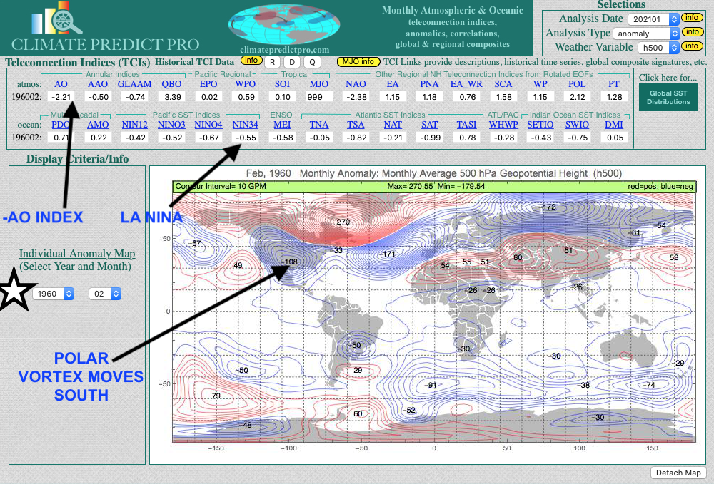
Funny story I told my dad to buy natural gas. He went to his broker and the guy told him when it comes to that areas he listens to joe bastardi. My dads calls me back, hes like, my broker mentioned some guy named Joe bastard or something do you know of him? I loled. This was back in early Jan when the SSW happened. I bet this continues to rise.
-
26 minutes ago, JakkelWx said:
John pretty much summed up in one tweet what I couldn’t in 58 posts, but yeah, elongate the PV, puts low heights in 50/50 region, hp builds in and roll the dice. Still need to time the branches good as always. Doesn’t garuantee anything, but like playing poker you put your chips in when ahead and should do well in the long run. I told my friend 2 weeks ago that if Philly didn’t get an inch of snow in the next 3 weeks I’d go streaking down Broad Street. I’m not there yet for a similar proclamation, but only because it’ll be a lot colder over the next few weeks and no one wants frozen nips
-
2
-
-
2 minutes ago, psuhoffman said:
I am not putting the kibosh on the Sunday storm, it’s tricky but could happen, but the period after that is a more classic way we score. There will be a pretty extended window after the block retrogrades again and the tpv shifts through the 50/50 to get something to amplify the trough. I would say like 4-5 days. That’s enough time for multiple SWs to have a shot at it. Just need one to break off the tail of the trough and dig into the east to link up with the STJ.
Bingo.
-
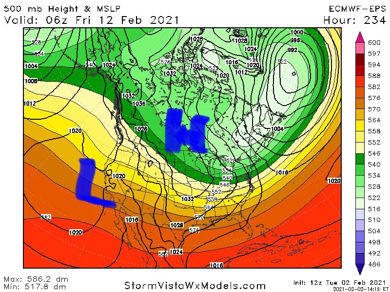
2 minutes ago, frd said:
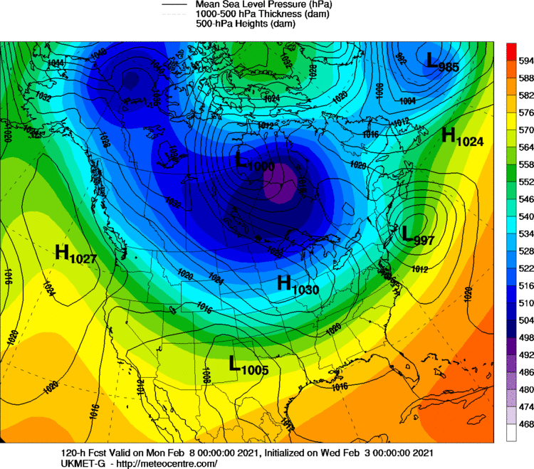
Did you see the almost 1060 High pressure system above Montana at 240 hours in the Euro HI - Res ?
Yes here is eps at same time showing that HP starting to build in. So basically what I’d hope would unfold here is you can see hints of a split flow on the west coast. As the ULL around the lakes head east into 50/50 region it gives room for the Hp to build behind it. Then you have cold airmass in place for whatever comes out west underneath the Rex block. I can’t explain it as well as psu or others but def keep an eye on this time frame. Until then there def a few waves we could score a modest event out of.
-
4 minutes ago, frd said:
Interesting, look out West as well.

Yeah that’s the Rex block under the -EPO. With a full finished retrograding block. Verbatim the euro has a wave down south there pressed under the NS tpv, but at this range not worried about details. Once that big ULL over lakes would move east if that split flow is modeled right and spacing is good. It’s game on. It’s exactly how blizzard of 96 formed.
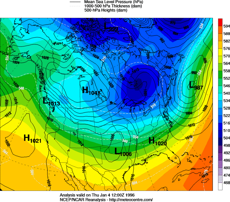
does this map look familiar to anyone??
4-5 days before the blizzard of 96
-
5 minutes ago, leesburg 04 said:
Wentz just canceled the back half of February

Haha sorry guys lol. There’s plenty of opportunities before that it just seems this winter the big ones happen at the end of the pattern as -AO relaxes. The fun part is we can rebuilding the -AO.
-
We’ll have multiple shots as the block retrogrades and then a HECS opportunity once the block diminishes for Archambault event feb 10-17. The retrograded block forces low heights out over 50/50 region with potential split flow underneath -epo. This month could be epic if things break right
-
1
-


February the climo snow month
in New England
Posted
I think it very well could be. There are some deep lows on those individuals. This is a sensitive setup where if you just neg tilt that wave a little bit more kaboom.