

Heisy
-
Posts
8,369 -
Joined
-
Last visited
Content Type
Profiles
Blogs
Forums
American Weather
Media Demo
Store
Gallery
Posts posted by Heisy
-
-
Hey all! I storm chased up to Dover NJ. Finally got lucky, band stalled over this region all afternoon. Total anywhere from 24-28”, and I’m sure there is isolated 30 spots. Just wanted to see 2 feet somewhere this year and it happened, the rest is gravy.
anywhere, onto the LR
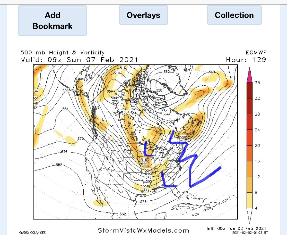
Sunday, the issue with this potential event is that the wave is just an extension of the tpv. This unfortunately could allow HP to slide off the EC and put a low in the lakes. This could still work if the two vorts dive farther SE & with the block this could very well happen.
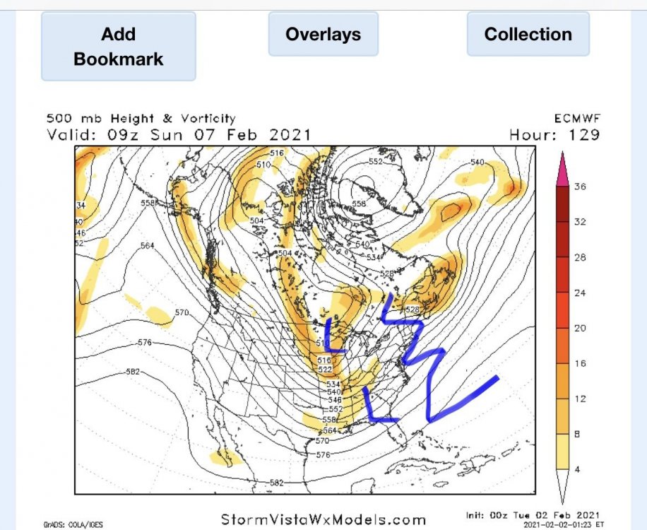
I am highly interested in the day 10-15 time frame. We usually cash as things break down or relax a bit. On this map you can see the block has retrograded. This has allowed a huge 50/50 ULL to form. There’s bit of a split flow out west. What would be important here is if the block retrograded more southwest than due west. If the NS cooperates this has big time potential.
-
 5
5
-
-
30 minutes ago, ForestHillWx said:
I wrote in the interior page, bluewave linked a tweet yesterday from a spotter who measured 24.5” at 4:00 pm. I was finding averages of 22.5” at that time. Since then probably another 2.5-3” with snow falling. Great storm.
Yeah just a complete guess dover id say 25-27 makes sense fallen (maybe more). Otg probably less since overnight with the weight. Those bands currently are just to my west.
-
1
-
-
2 minutes ago, TheSnowman said:
The guy who took the picture in Mendham, NJ with 30”, is a Compact total! Not 6 hours. And that was 8 Hours ago at 7:40pm! It’s been snowing since!
I’m 25 minute drive NNE from there in Dover. I don’t measure so just going off official obs. At 7pm a place 15 mins southwest of me had 25.8. I’m guessing we finish 28-32” here. It’s been snowing lightly all night. This region jackpotted because of a nearly stationary band between like 2pm-6pm
-
26 minutes ago, Ralph Wiggum said:
Snow has not stopped here in Warminster. Had another heavy batch roll thru over the past 90 mins. We are closing in on 12" now. 12k NAM has an additional 2-5" here in Bucks today. Wouldn't be shocked to see that verify. Radar has more backbuilding into the area.
Damn my dad is up near warminster near Davisville/street. Nice hit
-
1
-
-
9 hours ago, Violentweatherfan said:
All I can say is damn is it must be frustrating to be a paid met. Everything was there, how can you go against what the "model consensus"? I'm bummed but not gonna rail against those that share what they learned over the years and posted for us to read that a huge Milller B was gonna shellac us and didn't.
I think a lesson learned for myself and others is h7 pass. Anytime you see the models have an h7 low on top of us you should expect a warm layer to exist. Need it to be farther SE
-
1
-
-
On 1/30/2021 at 1:47 AM, Rjay said:
2nd post in this thread too. Shame we missed the 10 year anniversary.
This is also one of my favorite storms down in Philly. Waa snows overachieved and surprised in the first part and while the gap kind of sucked the main show was incredible with white out conditions for a few hours.
-
Sweet vort pass on last nights euro. Other models sort of backed off a bit but not enough to not be interested. This has a SNE up through NNE look to it. Issue I have with setup is the trough is kind of hooked up back towards Canada. Kind of an extension of the tpv. Would probably be a fast mover but a crusher if this verified.

-
Anyone near dover have latest official measurement? Looks like we will have light snow with moderate bursts through most of the day. My guess is we could get another 1-3” , regardless it’ll make for a very scenic day with 2ft+ on the ground
-
1
-
-
Just now, jm1220 said:
Gravity wave bands SE of Long Island. This one's definitely legit.
I’m legitimately thinking I have a shot to hit 3 feet here. It’ll depend what happens late tonight and Tom if we can add on like 2-3” after this band fades... it’ll be the most snow I’ve ever seen
-
2
-
-
Just now, ForestHillWx said:
Most we’ve had since 2016; it’ll be close if we break it. I had 32.5” in that one. I’m over 25” now. Dover-Chester Road, about 7 miles between the towns.
Keep me posted on our official total. I think this band has a few more hours in it. Then late tonight into tomorrow probably wind whipped light snow so will be close! I’m at the Hilton Dover Rockaway
-
1
-
-
2 minutes ago, jdt said:
I was over 25” two hours ago in Sparta. There will definitely be a 30” total somewhere and perhaps 36”.
The band just reignited, Jesus this Is nuts!
-
Hey guys, I finally may jackpot a chase, or close to it. Currently in Dover NJ. I’ve been sitting in the south end of this band all day. It refused to move west of me. It’s been 8 years coming since I made my first chase up to MA for feb 2013. With what’s left has to be a chance for 30-35” I just don’t know what type of rates we see overnight/tomorrow. I also don’t measure so just going off official nws measurements.

-
3
-
 1
1
-
-
I’ve been getting a stalled ccb band train through here all afternoon. I left Allentown late day yesterday to come to Dover. Probably wouldn’t have mattered, but I may end up over 30”
-
21 minutes ago, NJwx85 said:
It’s been unreal here, dover. I’ll be stuck here until Wednesday afternoon
-
2
-
-
That band over dover region has just been training all day. Not letting up. For once I got lucky on a chase lol. Probably end up between 23-27 all said and done
-
1
-
-
This band over dover NJ is just locked in at this spot. Thought it was gonna go west it’s actually sunk south. It hasn’t left in over 2 hours I have just enough latitude. Have to have close to 20. Anyone live near dover that has a official total?

-
Just now, ADKNYCPA said:
13 inches in Allentown, PA - 29 degrees and still very heavy snow
I left Abe for Dover nj late yesterday after the late model trends, will be curious who gets more haha
-
-
I may sleet all the way up here in dover nj, well not before up to 2 feet, but shows how far n and undermodeled it is
-
I imagine this line just moves with the back edge of precip so it doesn’t really matter

-
Just now, omo_yankee said:
worried we sleet for a bit
The mixing radar has it moving n steadily fyi
-
Here in Dover 30 looks more of a reality than 20, radar looks unbelievable
-
2
-
-
Anyone near dover have anofficial measurement? Curious what I have I’d guess close to a foot but idk. Getting close to the epic stuff
-
Just now, nesussxwx said:
We still have a long way to go up here, no worry about a slot either. Should hit 25"
Oh I’m in heaven ha was just speculating. Radar rep kind of reminds me of a farther southwest nemo, cough, feb 2013 lol
-
2
-
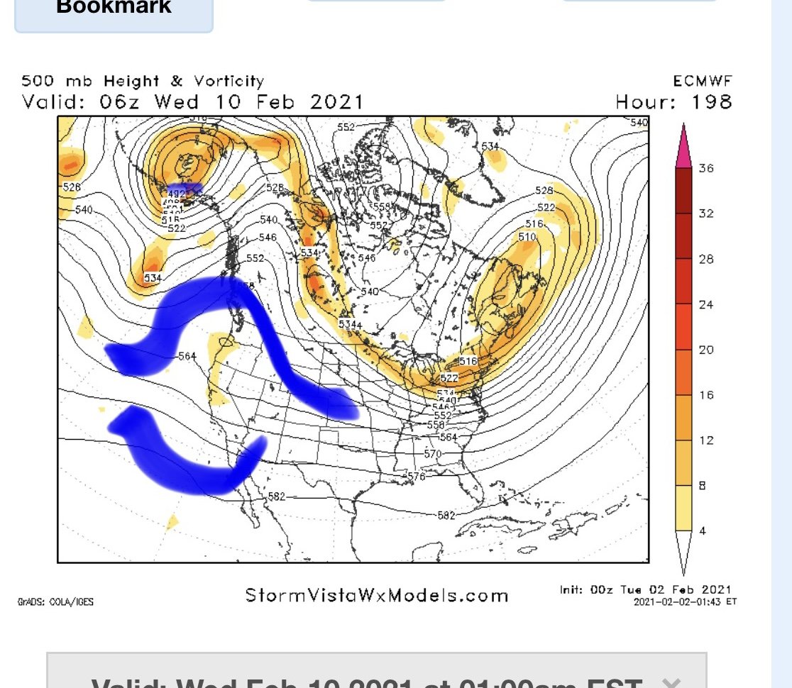


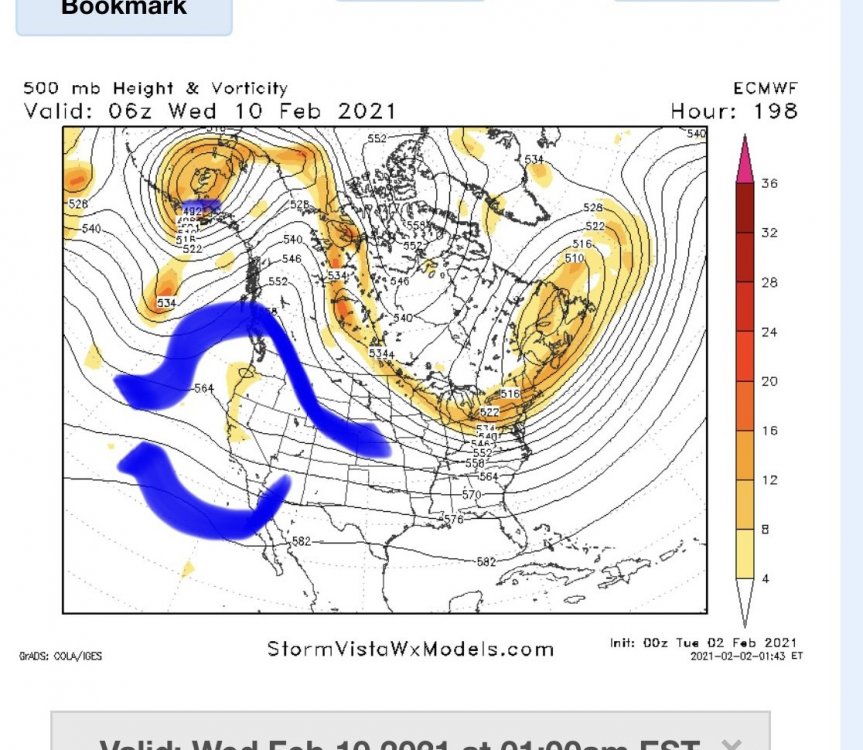
Feb Long Range Discussion (Day 3 and beyond) - MERGED
in Mid Atlantic
Posted
I’m telling you guys whatever happens over next 10 days is gravy. The pattern at the end of euro is HECS potential. We do well at the end of the pattern when it’s about to break down. There’s a split flow setup with lower heights all pressed east into 50/50 region. At this range timing and placement of features is crap, it’s the overall idea you look at. We’re way too far out to know the details but feb 10-17 should have a legit shot at another major event for EC.