

Heisy
-
Posts
8,369 -
Joined
-
Last visited
Content Type
Profiles
Blogs
Forums
American Weather
Media Demo
Store
Gallery
Posts posted by Heisy
-
-
5 minutes ago, jm1220 said:
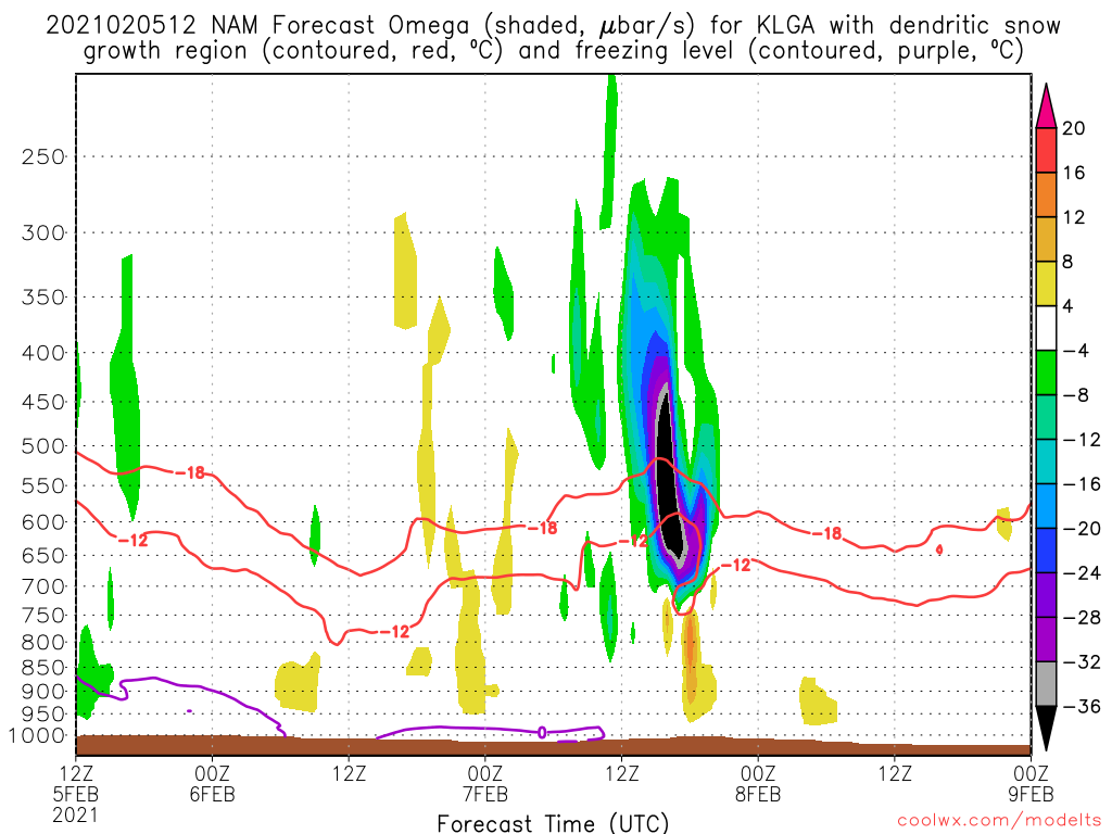
If this is right, short lived but very heavy rates and lift squarely in the -12 to -18C part pf the column. For LGA:

Hey man, where can I find these charts? Would like to see them centered for philly
-
10 minutes ago, bluewave said:
It will be interesting to see if we can get thunder snow with this one.

Man I hope that verifies. should be a very convective looking radar, nice
-
 1
1
-
-
Just now, WinterWxLuvr said:
What time do the gefs come out? I know it used to be around 12:30 but I think some of you post them a lot earlier now
They’ve been out. I’d actually say they ticked SE oddly enough
-
Nice hit on 12z uncle
-
1
-
 1
1
-
-
Yikes on the 12z cmc. Has front ender same time period as icon and then has wave after wave with CAD stuck all the way down into the southeast. Verbatim would be an historic ice event
-
1
-
-
Love how cmc/gfs all trending towards icons progression with an arctic/stalled front. Now the exact position of the tpv is gonna determine what happens. Need as Far East as possible or stretched out
-
Cmc crush job as expected with rgem being good

-
Gfs, getting there, keeps getting better every run

-
4 minutes ago, LP08 said:
Verbatim is Snow/mix/snow for the I-95 crowd. NW is a very big hit. Temps never out of the 20's.
Yea SV snow maps accum snow for sleet. But surface is plenty cold
-
The new king, the icon

-
-
Huge hit on icon day 6-8
-
Holy crap check out icon day 6-8
-
 1
1
-
-
2 minutes ago, wdrag said:
I saw the 12z/5 NAM. I sure hope RGEM/GGEM CATCH UP... nice storm, no matter whether warnable or just advisable. NAM is definitely on the higher side and consistently so.
Will review details for myself at 330P and then check back.
Rgem did catch up Walt, finally heh
-
 2
2
-
-
Icon is the new king, all hail the king
-
4 minutes ago, JMcCaughey42 said:
I'm going to be in Ocean City this weekend...rough commute home on Sunday morning?
I would certainly stay tuned as sunday am is the heaviest part of the event. It’s a heavy wet snow so might have issues sticking to the roads at first, but if it’s heavy enough it WILl stick and the large snowflakes we’ll see should stick fast once the column cools. Could make things very slippery, of course main roads always better. You’ll know once you wake up Sunday if it’s worth it
-
1
-
-
Just now, Ji said:
has anyone seen the NAM3k Temps during the height of the storm. 32-34. This has like an 80s wetsnow vibe too it @psuhoffman
I love those types. Accumulates quickly on cold surfaces, gradually covers roads, it’ll be a winter wonderland hopefully and then we drip
-
1
-
-
1 minute ago, Ralph Wiggum said:
It will be a quick mover. These are one of our most common setups for snow around here. Wave forms along baroclinic wave left behind from this AM's departing system. Not saying it can't overachiever but in general thru the years I've seen these trailing waves drop a solid thump with the f gen banding then usually just lightly accumulating snow behind that also zips out quickly.
These systems are textbook...minor warning event. The very high end is probably a 5-10" for whoever gets under the best lift and has ratios....which will be a challenge in and along I 95. Just figuring out the snow axis still seems the challenge moving forward.
I’d favor just SE of the city right now for the isolated 8-9” pops but that could change if this trend continues
-
1 minute ago, VA Mad Man said:
I'd imagine NWS will hold off on issuing a WSW until after the 12Z suite?
My guess would be after Euro. In the afternoon.
-
Wow, you can see how stronger the shortwave trended here...squint hard enough

-
1
-
-
Rgem looks really good curious where it goes from there heh
-
-
18 minutes ago, adelphi_sky said:
On Channel 5 News this morning they were saying 1 - 2 inches with a mix ending as rain this Sunday. I'm confused. They didn't even indicate that totals could be higher.
Because there is still a question of how Far East the storm forms etc. models keep trending better though
-
I’d ignore the 12km and stick with the 3km, that being said it’s still a very good hit for a progressive system. If that fgen band forms as the NAM says someone inside the max axis would have a shot at 8” of heavy wet snow as it should promote heavy rates and good snow growth


Feb Long Range Discussion (Day 3 and beyond) - MERGED
in Mid Atlantic
Posted
Big changes on euro so far, should be a similar progression to the rest of the globals today. Well see if it stays cold enough