

Heisy
-
Posts
8,369 -
Joined
-
Last visited
Content Type
Profiles
Blogs
Forums
American Weather
Media Demo
Store
Gallery
Posts posted by Heisy
-
-
5 minutes ago, ORH_wxman said:
06z GFS tickled NW. interesting set of trends in the last 12 hours. Some models going SE and others coming NW.
Threat definitely still alive but need to narrow these goalposts.
Quite the difference between 3km NAM and 12km heh....before last event tony (rainshadow) posted the model that’s supposed to be replacing the NAM eventually. It did a decent job. I’ll see if he can post it later today for this event
-
Just now, BristowWx said:
Looks nice to me at 54
Yea great run. Not quite, but starting to get bit of a consensus here.

-
6z gfs slightly improved, bit more ridging thru 51hrs
-
 1
1
-
-
27 minutes ago, WxMan1 said:
06Z NAM Nest for Sat night-Sunday. Definitely juicy. This is with the Ferrier rime correction (capped at 10-1). If it's all snow w/o rimed flakes and a >10-1 SLR, we would get more.
The NAM Nest Ferrier snow maps did a pretty good job in the DC area for the WAA phase in the last event (on Sunday).
Before the last event on our Philly forum Tony (rainshadow) posted the model that’s supposed to be replacing the NAM soon. I forget what it’s called, but it did an amazing job. I think it begins with a C but idk lol. I’ll see if I can get a snow map off its recent run.
I found it...
so supposedly this will be the model replacing the NAM. This was its forecast before the last event

-
3
-
-
The 00z eps is back to progressing the pattern the way I originally mentioned. Where the TPV heads east and the main low is behind that instead of being a front out ahead of it. This is a juicy mean for this time frame. Legit.

-
1
-
-
10 minutes ago, WxMan1 said:
06Z NAM Nest for Sat night-Sunday. Definitely juicy. This is with the Ferrier rime correction (capped at 10-1). If it's all snow w/o rimed flakes and a >10-1 SLR, we would get more.
The NAM Nest Ferrier snow maps did a pretty good job in the DC area for the WAA phase in the last event (on Sunday).
What is the NAM nest? Like an ensemble of all the different resolutions?
-
1
-
-
Icon is gonna have the day 7-8 overrunning beast event that the gfs has too FYI.
-
1 minute ago, psuhoffman said:
ICON looks slightly more amplified then 18z through 46 hours fwiw.
I have it out, it looks like NAM to a degree with that heavy stripe

-
1
-
-
1 minute ago, psuhoffman said:
RGEM is yuck. It has the next system right on its heels. That is not helping. It is way ahead of the progression on the NAM and GFS with that next wave and its way more amplified. I think that is kicking this thing more on the rgem and cmc.
Was really hoping to nab the cmc/rgem tonight. It’s not an all hope is lost type thing but it’s a big red flag
-
1
-
 1
1
-
-
Think this is just the NAM correcting to rest of guidance. It was obv a bit over amped. Once we get under 24-36 hours we can start seeing if the fronto band can get far enough N to get the heavier stuff into Philly/nyc.
-
1
-
-
-
6 minutes ago, WinterWxLuvr said:
The SREFS aren’t wetter. They may be better snowfall wise but the precip in our area is about the same and down in southeast Va they are drier. Also driernup the coast. Not what I wanted to see. I wanted wetter and more west basically. I’m looking at the 24 hour totals at 3 z Sunday night.
Idk this looks better to me ?

-
1
-
-
10 minutes ago, Buddy1987 said:
Idk man I think you would agree with this sentiment but the Euro hasn’t been itself as of late. Maybe I’m wrong or maybe there’s a compromise in between more amped models vs Euro/CMC combo but those developing winds at 250 just scream some awesome moisture transport so I think regardless we have some good advection and some good quality rates even if the storm is progressive in nature.
When it comes to the LR the euro will always be #1 imo. Frankly it sniffs these out much faster than other models. At this range though it is susceptible to ticks in either direction. Seems odd but happens. This really feels like an event where we see an uptick on the euro once inside 48 hours. Idk, just has that setup
-
21 minutes ago, MJO812 said:
Most likely late to the party. We will see.
Fairly confident we’ll see uptick on euro as we get closer.
-
1
-
-
1 minute ago, HVSnowLover said:
This isn’t likely to be 10+ it’s a fast mover
Agreed. This is more of a 3-6 with pops to 8-9 if full potential reached
-
1
-
-
26 minutes ago, jm1220 said:
18z and 6z runs also incorporate updated data. It’s a myth that somehow they just run off previous 12z or 0z data.
I think that’s a half truth. From what I understand they use 6hr data from the previous run, and add some new data. I might be explaining this wrong but I had a convo with a met on phillywx. Regardless off runs are still updated and worth taking serious
-
36 minutes ago, MillvilleWx said:
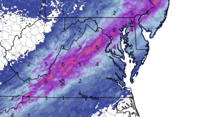
Well well well, looks like we have ourselves a nice little event on the horizon. As we've seen the model corrections back to the NW have been due to backing from the extreme cold scenarios that place the baroclinic zone further to the south, as well as the amplification of the southern wave that descends from the Rockies down into the south-central plains to the Tennessee Valley. A couple of things to point out so far with current model progs.
The first thing I wanted to touch on is how the trough behavior has been important in getting the precip field further to the NW and why there is still a bit more room for further westward expansion. Below is a gif of the 5H vort panels off the 18z GFS which now has the precip field well to the NW of where we were this time yesterday.

Notice the vort as it swings east of the Mississippi begins to take on a more neutral position with a slight negative tilt by the end of the gif as it enters VA. This is important as this places the best diffluent signature further to the north and east ahead of the amplifying wave. In turn, this promotes better mid-level lifting mechanisms to come further NW as the trough pivots east of a longitude of Nashville/Indianapolis.

Here's a look at the GFS 700mb frontogenic forcing for Sat night into Sunday morning. Notice the expansion of the lift further NW with SE to NW progression of the mid-level frontogen placement. This will allow for an expansion of the precip field, imo, to be a bit more pronounced to the NW, and maintains a strong lifting signature for Central MD over to the western portion of the eastern shore. This is why the GFS now has the max precip field bisecting the I-95 corridor to about 50 miles on either side. It will be important to maintain the current wave amplification in order to capitalize not just the precip field expansion, but promotion of the best forcing to the NW.
The NAM is fairly aggressive with the 7H frontogen as well. In fact, it's incredibly robust and should favor a period of 1-2"/hr rates within the northern periphery of the frontogen placement. Again, this is due to the negatively tilted trough axis as it pivots to the east. Check it out below:

Here's the trough axis during the prime time period of the incoming precip field....

The area in the box ahead is a strong diffluent signature that provide the sufficient lift ahead of the pivoting trough, leading to not only precip expansion, but also better lift to generate mesoscale banding structures with persistence as they trek to the north and northeast. One thing I haven't shown is a strengthening 25H jet signature to the northeast that amplifies and places the region right within the right entrance region of the jet. This is why the precip blossoms so quickly on the QPF side of guidance.
As long as we continue to keep the current 5H presentation, I think the stars will align for a progressive event, but will have thumping potential given the current lift progged. Lowest boundary layer is the primary concern at the moment, but a marginal setup overnight can absolutely score. I think a general 3-6" with max of 10" somewhere is well within reason considering the trends. A slight tick colder and we'd really be in business.
Amazing post! I’ve been looking at the fronto on the mesos. While out of range it highlights the potential. If this shortwave can neg tilt and the trough axis aligns perfectly this will be a classic heavy wet snow event for someone. Could be a lot of 30-35dbz type in the radar inside the max axis of the precip. Hope the trends continue because I love fat white out flakes
") regardless of how quick it moves
regardless of how quick it moves
-
4
-
-
You guys have the RPM frame or two prior to the one posted? I know wrong forum but I have no clue where to find the model. I need more happy hour love
-
This won’t verify, but is crazy to see

-
1
-
5
-
-
Just now, Always in Zugzwang said:
Well, you and PSU (and some others) kind of highlighted that time period, and it has been showing up for a bit in various forms...so credit where credit is due if we score!
Oh, and your phone needs a good charge again, LOL!!!
Haha yeah. Thing is it kind of happens not in the way I expected, but as long as it snows idc!
-
1
-
-
4 minutes ago, CAPE said:
This is a possible outcome with the sort of h5 look being advertised. I would sign up for that.
The only caveat is if the tpv end up too far west then it runs inland, but I think the day 6 wave helps push the boundary east.
-
Gfs crush job next week, wow what a run.

-
3
-
-
18z Gfs might have a big overrunning event this run. We’re going to see different placement each run of the TPV near the conus border. Where it sets up & how much breaks off on the day 6 wave will dictate what happens toward day 8-11
-
7 minutes ago, WxUSAF said:
I really like @psuhoffmans house as the jackpot
Forgot that! Also obv the elevated areas of va and nc could do really well too, but near the metro region I’d prefer to be in DE right now, thought I’d never say that.


Mid to Long Term Discussion 2021
in Southeastern States
Posted
That’s one of the beefiest means you’ll see at this range on the EPS for day 8-10