
Heisy
-
Posts
9,445 -
Joined
-
Last visited
Content Type
Profiles
Blogs
Forums
American Weather
Media Demo
Store
Gallery
Posts posted by Heisy
-
-
-

March 58, one time?-
 1
1
-
 1
1
-
-
The severe wx from this front will be fun Monday evening
-
1
-
-
Just saw the reporting of blizzard going to hit the Midwest Sunday with sever weather along the mid Atlantic
Snow maps a combination of a few waves. I’ll be living vicariously

-
-
Euro has an inch or so verbatim. Could be some flakes in the air.
6z euro is pretty darn good for dc Balt. -
Gfs is sweet for you guys. Factor in time of year, time of day, obvious factors. I do think if everything aligns it will rip in places for a few hours.


-
5
-
 1
1
-
 2
2
-
-
-
00z NAM should be better. Looks like more phasing with the southern wave. See what happens. Can’t believe I’m tracking this haha. A dude just scored 83 pts in an nba game, anything is possible
-
1
-
-
Looking forward to possible destructive storms tomorrow and colder air rushing in Thurs with the high being in the morning. I'm done with the current life threatening heat wave...
77F
Had a bee fly in my car today. Flash freeze all the insects -
We do well with anafront snows. Remember the Anafront storm of '21?
Neither do I.
The only one that I really recall up here in Philly was maybe March 2015. Dates might be mixed up though. -
FV has this line setting up directly over the city for a few hours
Is this an anafront? Or just a weak wave riding the boundary?
Looks like an Anafront to me
-
1
-
-
Kuchera probably more reasonable in a situation like this. Gotta see if this continues next few runs or if it was a random off run blip

-
1
-
-
GFS is fucking nuts lol. There was 'some' support earlier, but not now. If you read the local NWS AFDs, not even a mention of snow.
18z euro lol
-
4
-
2
-
 1
1
-
2
-
-
ITS ALIVE

The 18z euro jumped on board too fwiw-
2
-
-
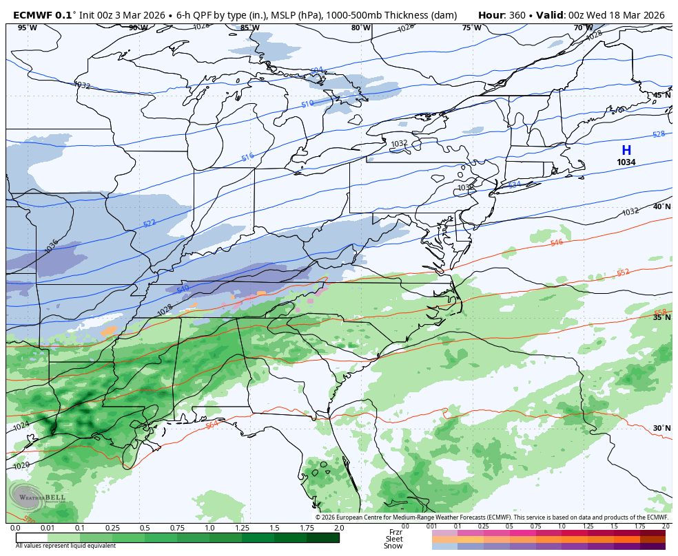
I’d pay big money to have the end of the cmc verify. That was about to be a spring hecs ha.
If we’re going to get a snowstorm it’ll probably be that wave around 18-19th.

-
2
-
 1
1
-
-
Winter 25-26. Never forget

Still getting rogue model runs of snow 17-20th range. Doubtful, but not impossible-
1
-
1
-
 1
1
-
1
-
-
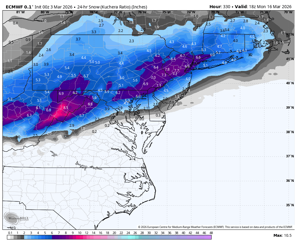
18z euro Ai semi close to a nice hit day 10-12. Euro def has some interest for this time period.

Here was the euro for the same time frame
-
3
-
-
18z euro Ai has 2 snow events in this range
-
 1
1
-
2
-
-
18z euro Ai has 2 snow events in this range
-
The second of those weeks could be our last trackable window, say 3/15-20.
eta: fantasy land caveats apply
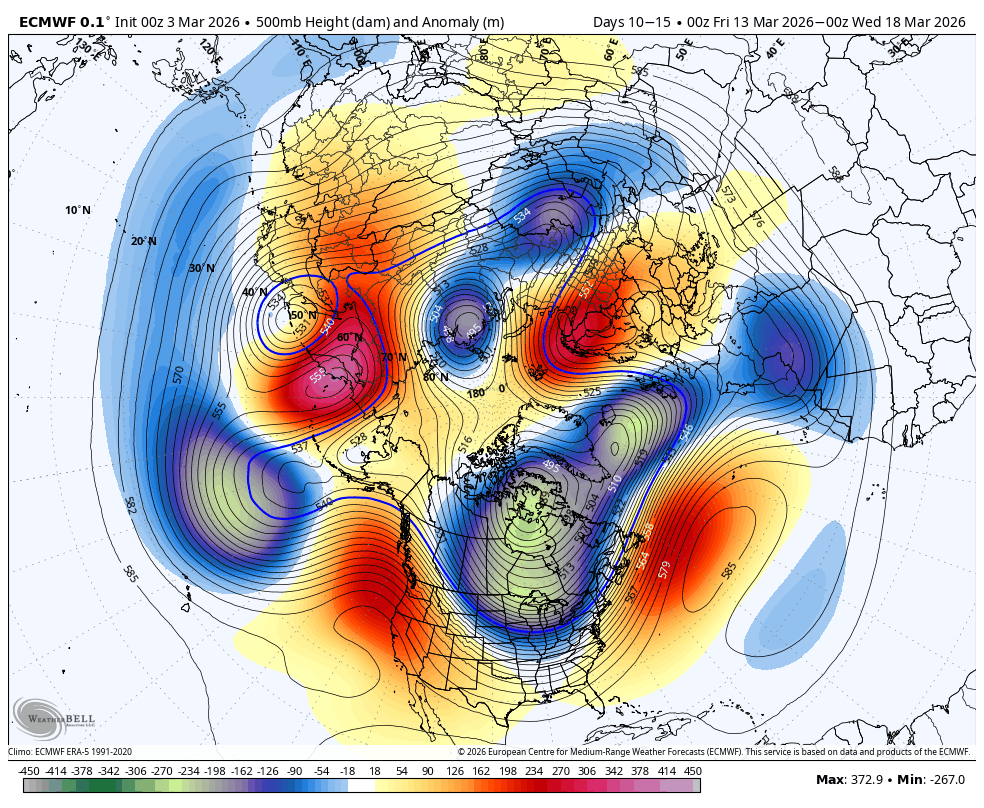
Signal for a nice +PNA growing on euro guidance. It’s more muted on GFS/GEFS. Without blocking though wed need well timed waves. Shortwaves timed right after a cold front. Significant snow likely a long shot, but we’re going to get some decent cold shots if this is legit.


-
WB 0Z EURO gives us two waves of digital snow to watch. Only 13 days of tracking to go.....


Just for fun, it’s March whatever ha, but this was about to be a massive nor’easter, and cold/frozen by the looks of it

-
3
-
2
-
-
This strong front keeps showing up on the euro Ai and euro to a degree. It’s also on the EPS. Around day 8-9. We saw the euro have that fantasy event. It was also loading up at the very end of the run. It’s a +PNA pattern, but not much blocking showing up so probably would have to time waves perfectly


-
Re-enforced by -PNA pattern though. We need that Pacific High pressure to change. Some lite signs of -NAO loading pattern setting up...
With the SSW event I suspect we’ll see some -NAO showing as we head towards mid month. Just a gut feeling. We’ll probably have BN period second half of month. If we’re lucky maybe even a freak frozen event. Never know


It's time to grade Winter 2025-26(now that it's actually over)
in Mid Atlantic
Posted
A- up here near Philly.
The NC storm was the biggest “what if” for me this year. If that storm had phased in sooner and came up the coast it turns into an almost perfect winter.