

Heisy
-
Posts
8,369 -
Joined
-
Last visited
Content Type
Profiles
Blogs
Forums
American Weather
Media Demo
Store
Gallery
Posts posted by Heisy
-
-
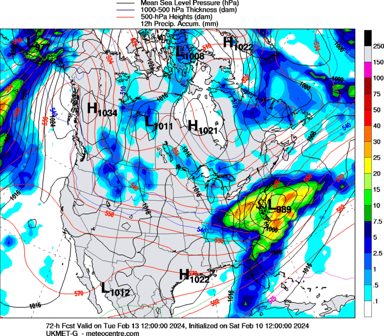
6z euro looks even flatter
. -
I would think euro will bump north some. But N&w burbs should do well with 3-6/4-8 & LV 6-12 & poconos 9-16
.
Agreed, I’m in Bensalem, maybe I can hang onto the ccb heavy precip later into the morning. Hoping for 1-3” of slush here we’ll see
. -
Insane shift on GFS and euro. Has to bump a touch N at 12z right?!
. -
-
-
I’d stick with the 3km NAM, not to be a downer, 12km just isn’t realistic

.-
 1
1
-
-
Storms like this are the reason I was always wanted to live in Mass. I love Philly, but man do we suck at snow. I’m almost 40 I gotta take the plunge soon. Enjoy it
.-
3
-
 1
1
-
 1
1
-
-
Pretty Similar to the 6z GFS
Yep,good sign. I mean personally I’m always aiming for a big dog but I’ll take a 2-5” event of course
. -
End of 6z control vs 00z… and slp/precip location. Def some significant changes to the H5 pattern. Pretty sure that was going to be small/significant hit there


.-
5
-
 1
1
-
-
If anyone wanted to know what EURO was going to do post day 10 take a look at the control run for sh*ts and giggles.. Some wild solutions are likely in the 10-15 day timeframe
Was about to post that, that was wacky fun to follow lol…
.-
1
-
-
Can we score during the
handlebar mustache pattern
.-
1
-
-
Ukie still south vs gfs/euro. Pretty wild model differences for this range
.-
1
-
-
Hope this is right and not the OP cmc

.-
1
-
-
Surprised no one posted the control, it’s 10:1 but is basically the extended euro.
This was a sick run for your region
.-
2
-
1
-
-
This run was likely going to clobber just Nw of Philly beyond 90 with ccb precip. Surprised down here, blip or real deal? Def a south push this run
. -
Yeah, we're shut out. Even Philly gets in on the action. And fuck NYC..it'll prob be warm there, so their gonna lose some of that accumulation on the models...like 8-10
I’m in Philly and i have major doubts we see anything either. GFS is horrid at snow forecasting. I’m also selling the cmc it’s been all over the place run to run. Seems to be playing catch-up. I gotta place in poconos I could potentially drive to if 15”+ is forecasted when we get close
. -
Better visible here. Look at the angle of the confluence. All because that darn piece diving in faster. Really annoyingly that close

. -
So now there's a northern stream vort that's in a different position vs 6z...more SE..looks slightly stronger also
That lobe is killing us. The runs from 00z and before kept it separate. Finally 6z caved and phases it a bit and it’s swinging the main low farther N
. -
Bet this comes farther N because GFS finally caved to other data and shows more interaction with the tpv lobe. Almost acts like a seesaw to swing it N
.-
 1
1
-
-
End of 6z control changed the pac pattern up a bit vs 00z euro run. Wonder if 12z can muster up anything with the STJ during 12z run

. -
It’s hard to say from one panel in a vacuum. It’s about a progression. But I think these two plots from last nights eps show what you are looking for.
The 18th here is a great “loading pattern” but it’s a look we want to see like 3-5 days before a big storm. It’s not a day of look.
The key here is that block 50/50 combo is going to press the boundary way south in the east. We want that because to get a big storm when a wave is on approach we need the boundary to our south. This sets us up. But look at the flow. Ridge axis is way too far east. The stj is way south. This is a suppressed look for this day. An STJ wave isn’t likely to amplify along the east coast under that.
But roll that forward to this. This is close to perfect.
the blocking is relaxing. The 50/50 Did its job but is now shifting east allowing room for amplification. The wave is centered in the TN valley. The ridge axis is in the mountain west. It’s subtle because all the pac waves will wash out a ridge at that range but it’s there.
If I wanted to be super picky I would still prefer that pac trough western ridge be a slight smudge west. But now I’m being really picky. That look there is close to the perfect storm look when taken in conjunction with the look ahead of it.
Blizzard of 24 24 has a better ring to it anyway
.-
1
-
-
It's 96-108 hours away, plenty of time for further adjustments. They had a completely different day of weather in Phoenix today from what their forecast said at 0800h. The weather girl on the PGA golf coverage set said she had no idea it was going to rain and didn't bring an umbrella. Of course in fairness, she probably doesn't have an umbrella.
Yeah, GEFS still looks decent fwiw
. -
Blocking still looks to peak around Feb 20. Making the PD storm unlikely unless a NS wave phases to buckle the flow. But my god I’ve never seen a signal this strong at this range before. As the block relaxes one of these pac waves will survive. A few days after the block peaks and starts to relax still makes sense.

Ha you beat me to it. Made my post before I saw yours. Now THIS is a map I want to see hang around. There’s actually room for amplification
.-
1
-
-
I’ve said since Jan I loved the sound of the 2/24/24 blizzard… well….
THIS to me looks more conducive for a classic storm than anything I see before imo, but we’ll see
It is wayyyy out there obviously

.-
6
-


Following a Miller A/B hybrid type coastal potential, Feb 13th ... As yet untapped potential and a higher ceiling with this one
in New England
Posted
6z euro looks even flatter so far
.