

Heisy
-
Posts
8,369 -
Joined
-
Last visited
Content Type
Profiles
Blogs
Forums
American Weather
Media Demo
Store
Gallery
Posts posted by Heisy
-
-
No change to pattern timing, but the “wait” just keeps getting warmer. Hopefully it’s just a product of sharpening the wave features leading up to the pattern change
It does seem early on the ridge out west looks more broad on the ensembles than it did previously , it does get there but there was a slight delay there over last few runs. Not a big deal yet. Still looking on track for the most part
.-
 1
1
-
-
Similar type progression as last nights euro could set the table mid month for an event. N/S energy advancing ahead for any left over energy in SW

. -
From our Philly forum…
00z 06 GFS show a PV split btw right around mid month. If we have some blocking at that time could even enhance everything. Ensembles just stretch it, just seems everything is lining up at just the right time.
.-
 4
4
-
-
Play that forward and the energy in 4 corners could work out depending on if the energy around the lakes is able to compress the flow a bit

.
By the way I was right. The 00z control turned that wave into a Mid Atlantic hit. Lala land but at least it’s an example of a more winter storm conducive pattern starting Feb 14-15
.-
6
-
-
Play that forward and the energy in 4 corners could work out depending on if the energy around the lakes is able to compress the flow a bit
.-
2
-
-
Eps Looks like what the cmc ensembles have been advertising for a few runs now. Pretty much all on board. How that actual pattern evolves to get here we’ll find out, may have a storm threat around 12-15 if there’s good sequence/timing of waves, but all the ensembles generally get to this point now

.-
5
-
-
We’re about 7 days away from tracking mode coming back.
. -
everything still looks on track for mid-month... MJO moving into favorable phases, equatorward Pacific jet extension will foster strong Aleutian low development, split flow, building -NAO via wave breaking in the N Atl. all ensembles are in really good agreement temporally and spatially
i'd like to give it another week to get this into a better range, but it looks good
Just need one big event and it’s a good winter in my book
.-
1
-
-
BECS 2'+?
Sent from my SM-S918U using Tapatalk
2 feet isn’t unheard of though so I wouldn’t consider that biblical. 3 feet plus imo. I’m an atheist though so what do I know haha
.-
1
-
 2
2
-
-
Even if it comes in pieces, we should do fine.. global precipitation is way above average, #2 was Jan 2016.
Too early to start a storm thread for Feb 17-18?
Chuck is hyped eh ha. I’ve had Feb 24 in my mind for some reason myself
. -
GEFS certainly on board. love the split flow showing up on all ENS
Yea hopefully any energy undercuts that ridge and heads east and doesn’t want to close off or form a Rex block or get stuck under there
. -
Yeah, the control will be the op and come out with the ensembles at 2pm next winter
I’d assume both the control and ensemble will have upgrades to them? Not sure what HRES meant in the tweet. Hires? Idk
. -
Yeah, the control will be the op and come out with the ensembles at 2pm next winter
I’d assume both the control and ensemble will have upgrades to them? Not sure what HRES meant in the tweet. Hires? Idk
. -
Wow, seems like that would be a big step backwards in resolution for short-term (1 - 5 days) forecasting.
I’d imagine the eps will be upgraded though
. -
What does this mean? Euro runs earlier and it’s just ensemble based?

Been told by Tom on our forum it means no more OP euro, it’ll only be the control and ensemble ran. Curious why they’d be doing this? Cost issues?
. -
Icon ftw? One time
. -
The 18z GfS is a step towards the progression the ensembles are showing. Epo ridge building, that western trough will eventually come E. We’re just in a waiting period and possibly a break your shorts out period until it does


.-
2
-
-
One thing we know how to do here is rain.
There’s really no mechanism to get it N. It’s just really based on how much latitude it has as it comes E. Terp is right our shot was if that ULL had trended West so that it could have phased. That’s not happening now. Outside the elevations of SE this one is likely a loser. It’s okay I’m gearing up for 2/24/24 blizzard
.-
1
-
-
Positives for LR I think… That western trough isn’t cutting off like 12z run, we want that to come East as fast as possible. There is probably going to be a solid 2-3 days warmup as the ridge moves through

.-
4
-
-
This doesn’t look like torch to me

.
Probably have a Rainer before the blues finally make it to us, but then we’ll likely have a favorable pattern 2nd half of Feb. would be nice to get a NAO
. -
This doesn’t look like torch to me
.-
1
-
 1
1
-
-
Pretty big shift with the ULL near NE on 6z eps. It gives us (especially mid Atlantic) a path to victory here if that thing can keep trending E. Wonder if we see some large scale changes at 12z today….

.-
4
-
-
That annoying Barney shot ULL needs to move east or west, where it’s at now on the euro won’t work. East could allow it to come N, W could allow it to phase better. Still in range where we could see large changes.
.-
1
-
-
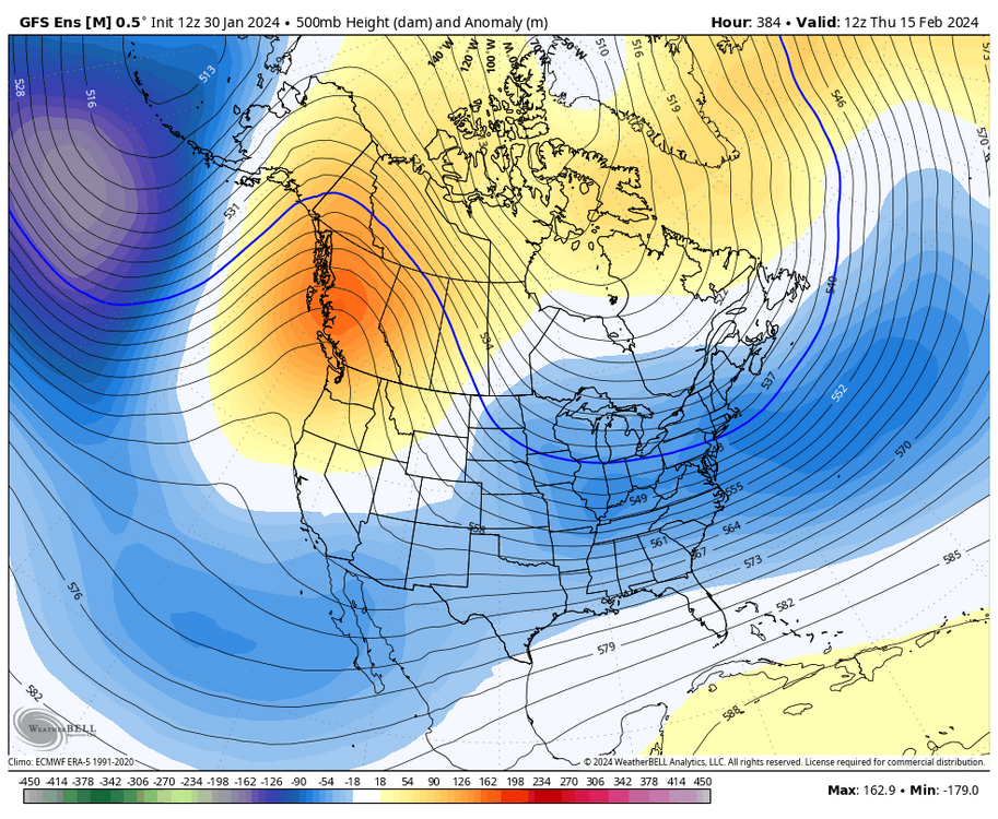
End of cmc ensembles finally get us to that weeklies look

.-
6
-
1
-
1
-
1
-

Mid/Late February will be rocking. (This year we mean it!) February long range discussion.
in Mid Atlantic
Posted
Not sure it was posted, this is just for fun with the range , but wow… that’s like a HECS setup cold dome over us and STJ gearing up.

.