

Heisy
-
Posts
8,369 -
Joined
-
Last visited
Content Type
Profiles
Blogs
Forums
American Weather
Media Demo
Store
Gallery
Posts posted by Heisy
-
-
6 minutes ago, ChasingFlakes said:
What year did this happen in the mid 2000s? I remember there being a 6ish inch event followed by so much ice that you could walk on top of the snowpack without breaking through. Made for some gnarly sledding carnage.
Valentine’s Day 2007 I believe
-
 2
2
-
 1
1
-
-
Weenie happy hour GFS run. Keeps confluence strong enough for wednesday night-Thursday. Might even be cold enough with next wave too
-
1
-
-
3 minutes ago, Amped said:
Going to be something huge for the middle of the country., we might be too far SE.
That’s an archambault event imo. Has a really good 50/50 & Hp early on but the trough is linked too far into the northwest and it takes too long to come east. Long way out
-
could be a pretty massive ice storm down in VA...
Also, Half inch of ice up near Allentown on top of all the snow they’ve had and will get sounds pretty terrible to me. That’d be wild.
-
4 minutes ago, The Iceman said:
Tt maps but I'm sure this includes some of the changeover. Would be very nasty! 3-6" thump then .025"-.5" of ice. Cmc also has a small event on Tuesday for the northern half of the forum. This week should be fun, I see 3 threats this week where we have a decent shot at snow, then we still have your storm lurking in the distance next week. Plus none of the models really show the pattern breaking down any time soon.

Thanks, the 12z gfs has “the heisy” event I’ve been talking about. It tracks a bit inland at H5 but is a classic archambault timing event imo. This is when the ULL moves towards the 50/50 region and the block breaks down

-
1
-
-
3” is my goal in northeast Philly. Well see. Just to see some heavy snow for an hour would be cool.
-
Cmc has a really bad ice storm day 5. On top of that looks like 3-5” or so falls before the changeover, plus the freezing rain is overnight. Anyone have maps? Curious how much snow it has before the changeover
-
Rgem and icon East FYI. Worried the NAM had the fgen too far NW
-
13 minutes ago, Kevin Reilly said:
Pretty significant shift in the end game
Actually it’s right in its range imo so should start looking like the rest of guidance. I wouldn’t use NAM or rgem outside 36-48 hours and honestly 9.99/10 go with the EPS for the snow axis and the mesos inside 24 hours for last second adjustments.
that being said I was personally very happy To see rgem shift like that. Haha
-
1
-
-
This is the Wentz storm time frame btw. Hope it can deliver. The big tpv has finally moved to 50/50 land. I’ll take my chances with this look! Just gotta get that pna ridge east a bit

-
1
-
-
Some of this is probably sleet, but check out this 00z eps snow mean for end of the run lol. Mjo you have the eps wxbell by chance?

-
1
-
 1
1
-
-
1 hour ago, Ralph Wiggum said:
RGEM ticked NW and EPS looks better for SE PA. 3-6" is looking good. Maybe some lollis of 8" in the best banding just to the NW of I95.
Sounds about right. The rgem ticking was huge. I think the better totals will be just east of 95 though, but I guess climo argues otherwise. Regardless anyone complaining about even 3-4” a few days after a mecs and with another event in the day 6 vicinity is nuts. This is awesome! Let’s get some tsnow tomorrow
-
2
-
-
7 minutes ago, Rhino16 said:
For future reference, Is it possible to save a map from SV to your photos on mobile?
Some of the maps don’t let you for some reason it’s odd. Only reason I screenshot
-
1
-
-
The new king just got juicier

-
2
-
-
Icon is juicy. King has spoken all hail the king

-
1
-
1
-
-
1 minute ago, Ji said:
i like seeing the Blue southwest of us. Lance will be happy this week
Looking at the surface and mid levels I think SV is wrong it’s more of a mix down there. Sv snow map likes to count sleet as snow for some reason. Better mean up towards us when comparing to wxbell
-
1
-
-
6 minutes ago, ORH_wxman said:
RPM and 3km NAM agree...that's an unbeatable combo
Will you have frame of that when it’s a little farther south? Appreciate it
-
2 minutes ago, ORH_wxman said:
That one would give PTSD to anyone in SNE who remembers it....I think it gave LI a foot and even croaked ACK but basically whiffed everyone else (maybe like 1-3" for far southern areas)
Yea haha I was just saying similar setup but the SNE whiff ain’t happening imo . Just another quick hitting event that dumped major totals in a quick time span. It’s certainly possible
-
Posted on our forum. Analog. Very similar H5 map with the NS and southern vort racing each other. Parts of Philly region saw over a foot in less than 4 hours. 2/23/87

-
3 minutes ago, Ravens94 said:
Really nice

While it is stronger that northern piece is pressing a bit more and is slightly more ahead of the flow, but I think this should be a good run
")
-
Eps has a better positioned TpV and its snow mean is probably the best we’ve at this range all year?

-
3
-
-
12 minutes ago, Amped said:
Not liking this trend, models consistently underdoing the SE ridge in Day 5-10 timeframe. Best we can hope for is a thump, then a lot of rain.

It’s not really about undergoing the SE ridge, it’s about where it dumps the big ULL. If you dump it was of lakes and far enough south you get an icon solution. More west like euro it’s maybe some front end to ice, drizzle. The ridge just responds to the placement of that feature.
-
Just gotta hope too much of the ULL energy doesn’t get dumped west since that’ll raise heights
-
Much more elongated TPV, should be interesting if cold can hold once energy out west comes east


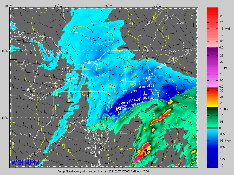
2-7-21 Sunday 8-12 hour nor'easter snowstorm roughly 5A-5P
in New York City Metro
Posted
Pretty much all the data heh. His call is spot on imo.