

Heisy
-
Posts
9,030 -
Joined
-
Last visited
Content Type
Profiles
Blogs
Forums
American Weather
Media Demo
Store
Gallery
Posts posted by Heisy
-
-
23 minutes ago, RedSky said:
NAM ticked 15-20 miles NW
That little bit is enough to bump Philly into a MECS
Probably way overdone on the Nam obviously, but you never know, it nailed 2016 when every other model was farther E
-
 1
1
-
-
Just now, SnoSki14 said:
Gfs will still be correcting as the storm begins
It's already corrected big time down here in Philly. You guys probably not paying attention but notice the snowfall amounts changing down here between 12 18 and now 00z. It's a joke. It will keep adjusting
-
7 minutes ago, MJO812 said:
Anyone have extra rooms for me ?
Hey I'm headed up tomorrow if you want to pick you up on the way lmk! Hah
-
1
-
-
I remember chasing to C MA for the 2013 event. Great event but S of me crushed. Then 2015 I head to RI and the goods go back to C MA
Each storm I chased I went to where the model consensus was for the best totals. You just never know. Last December I chased to Lewishburg PA and models kept bumping N.
I'm headed up there tomorrow with the girl. Can't wait! Haven't decided on a destination yet but it will likely be somewhere in SE MA.
I honestly think that I may have seen more snow fall at my location, wherever that is, then any person in the country. Guinness WW are you listening?
-
2
-
-
Going to head up from Philly Friday barring any more shifts east. Probably somewhere in SE MA, cape idk. Always enjoy my time up in NE. Was up there for 2013 and 2015, let's bring it home.
Ps. Sorry for the jinx
-
 1
1
-
-
Pretty painful that just the small change of having the wave eject faster would have locked up this storm as a HECS. As is there is still potential for a large event. I plan to chase as long as we don't see any more substantial shifts and the euro holds. SE LI could could a destination for me
-
3
-
-
22 minutes ago, ORH_wxman said:
The lesser southern vort injection is definitely a problem for further west solutions....agreed. Everything happens later and northeast the lesser amount we see southern stream phased in. The southern vort phasing in earlier starts curling the flow back to the left faster....when that curl is delayed, everything takes a wider right jog before eventually trying to come back.
It's absolutely devastating, especially down here in Philly, that mother nature deciding to hold back this wave just slightly cost us a potential MECS. Absolutely brutal.
Still rooting for you all because I plan to chase somewhere in MA
-
1
-
-
Top 3 worst winter of my life. I can deal with no snow, but to get constantly teased by the euro is an absolute nightmare
-
1
-
 1
1
-
-
Been a long time since we got NAMED
-
2
-
-
36 minutes ago, 40/70 Benchmark said:
I would def. sell that early of a capture.
Agreed. Can't wait for the upgrade they're giving to euro this year. Adding 50 ensemble members, extending 6 and 18z runs, better reslution....it's well over due
-
3
-
-
While you guys up in SNE can cash in regardless of early track the euro is really the only model showing this type of snow down here in Philly. I would urge caution right now with it. Early on in the run it looked like it was going to actually tick east. It held back more energy. It has caved towards other modeling many times this year, and for some reason during its off runs it seems to double down before doing so.
You guys should do damn good regardless though. Even eastern adjustment SNE would crush it still
-
2
-
-
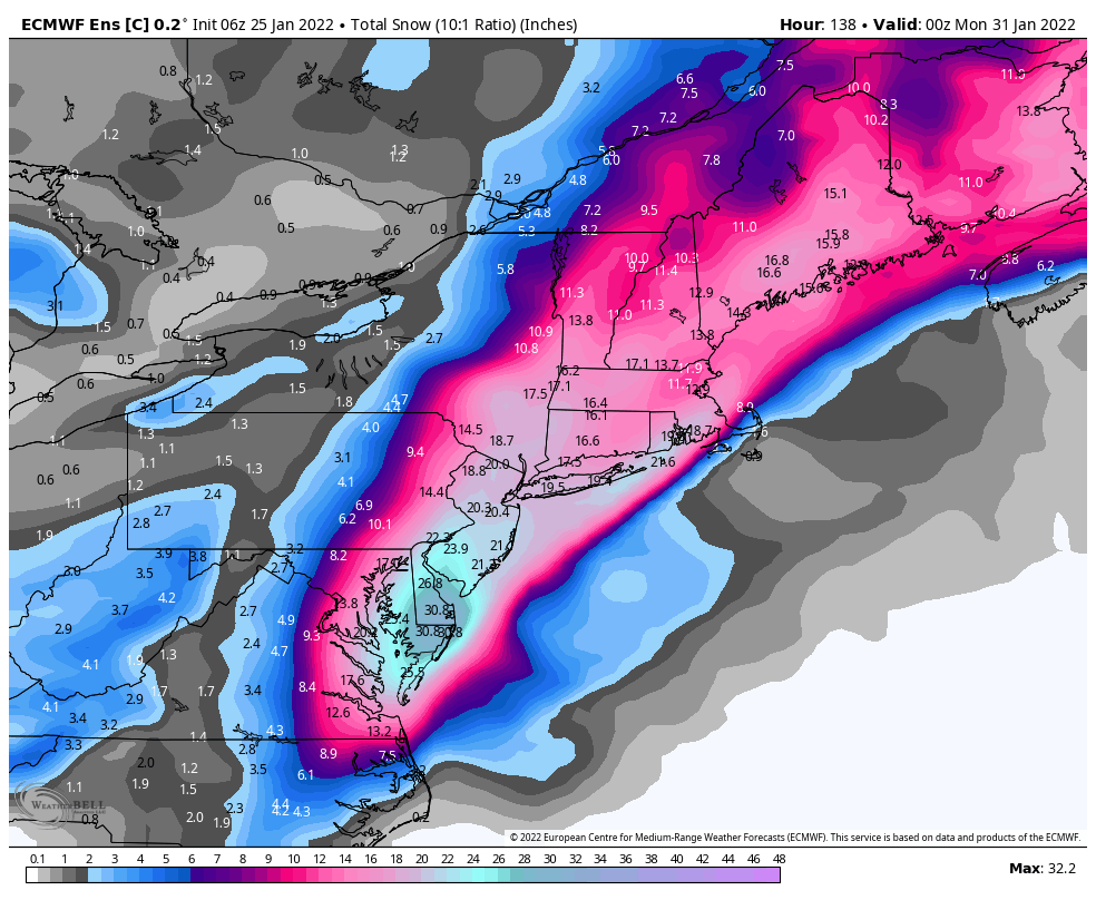
Not one 6z control post? Can't have that. Just close your eyes and imagine it's 24 hours out

-
9
-
 1
1
-
5
-
 1
1
-
2
-
-
6z euro looked better at the end of the run, but it did tick towards leaving more energy behind. It's just impossible to trust this model right now unless we see some support from other guidance. I think the wave will be on shore by 18z today. Might help guidance sampling
-
11 minutes ago, Typhoon Tip said:
Yeah there's no question ..this GFS run slipped the phase with the southern stream; immediately it translates to later bloom - removing also the MA from contention while doing so, and rending most impact to eastern NE at less so, too.
Noticing off the bat a signficant structural change between Hawaii and California/west coast, causing the ridge to re-position W and less amp.. This is allowing the southern aspect to cut back SW farther than previous runs ...that sets the stage for abandoning it when the N stream then amplifies.
It's a significant large continuity break so I'd take it with a caution pending further support. ... that wold be my suggestion for now.
18z cmc looks like it was going to split off southern stream as well. Energy is much farther west vs 12z at 84 hours
-
End of 18z rgem shifted the main wave farther west, this would lean more towards euro camp. Could see the cmc correct east tonight if that trend continues since cmc basically plays off the rgem
-
Just now, SouthCoastMA said:
If this was 2-3 years ago, I might be getting my hopes up that the other models would soon be trending towards the EURO. But we know how this story will end.
This is a lot different than previous events this year. There is actually support across the spectrum this time.
-
1 minute ago, RedSky said:
ECM ensembles lean West of the OP, sitting pretty for the moment
The 12z control did what I was hoping the OP was going to do. If only a little more energy headed east from main shortwave it would had

-
3 minutes ago, ORH_wxman said:

Lmfao. Land the damn plane already! That is insane all the sub 970mb lows on the mean. Hell, there's even some sub 960mbs scattered all over the place. KU 'potential' with this one for sure
-
1
-
-
-
This wave has huge importance to this storm (don't hate my photo editing skills). The 6z eps/euro/control actually pushed the main wave farther west towards four corners, but this second shortwave drops down and helps ignite everything. The control is an example of what could go wrong with a late phase. It still is a decent run verbatim.

-
1
-
-
@psuhoffmanmentioned it last night. Storm analog could be Feb3-4 1995. PNA driven storm. Storm that probably started my love of snow. Woke up as a scared 9 year old to thundersnow at around 5 or 6 am in Philly. Snow map looks very similar to 6z gfs output


-
2
-
-
-
34 minutes ago, psuhoffman said:
@Ji This setup reminds me a bit of the early Feb 1995 storm (see below). That was a +AO/NAO pac driven pattern. Very similar progression wrt the NS with a weak STJ wave also. If I recall that was a decent storm for us but obviously had bigger totals to our north. But that’s kinda a best case scenario for this storm type and what we should be rooting for here.


Wow good find, h5 looks very similar.
-
Cmc actually might bring low close or over Boston this run, tough to tell exact position with these maps
.thumb.gif.2e6fb2bcb399161f16a9382272e380af.gif)


.gif.eb90ddf6b38237d39edf504fb301ea96.gif)
Powerful Multi-regional/ multi-faceted east coastal storm now above medium confidence: Jan 29 -30th, MA to NE, with snow and mix combining high wind, and tides. Unusual early confidence ...
in New England
Posted
I flew from Philly to Colorado for last year's March event. I'm headed up to NE his morning, though I still haven't decided on a location. Its worth it screw it