

rjvanals
-
Posts
714 -
Joined
Content Type
Profiles
Blogs
Forums
American Weather
Media Demo
Store
Gallery
Everything posted by rjvanals
-
Good news is we don’t have to wait long til the ICON then RGEM then GFS tell us to go to bed before the Euro
-
3-6-13 was the worst bust imo
-
We have warning level snow as close as Waldorf w 72 hours to go; it’s not looking good but we don’t need a huge shift for warning level snow and super minor shift for advisory level. It sucks the MECS fell apart but let’s salvage at least something
-
Toggling through the Euro runs since Friday and there's only small changes synoptically so trying to figure out what has screwed this up
-
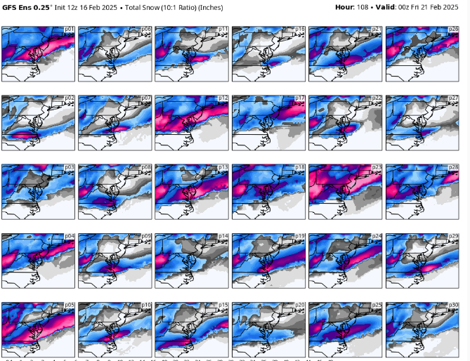
GEFS Panels
-
As I've gotten older the tracking and excitement for the next model run is 80% of the fun with having it actually snow being a great bonus.
-
Even if this storm trends to what we all fear, it was still a great long range call by @psuhoffmanto identify this as a threat window
-
It's crazy we're ~100 hours out with such a wide range of outcomes
-
a few flurries in Potomac
-
Looks pretty similar to this past storm snowfall wise on Pivotal
-
Hrrr is going to be wrong in the metro since it shows sleet coming into the area and I haven’t seen any reports of that
-
Its about a foot in DC more towards baltimore sleet makes it to 95
-
5.25 total in Potomac
-
I agree it has bust potential with marginal temps and being on the northern edge of the best precip. The best thing going for it is the majority of precip is progged to occur after dark.
-
3K NAM with a general 4-8 N-S is more realistic than the the regular NAM
-
The long range is pretty muddled until we get through the Tuesday/Wednesday system
-
31f w light freezing rain
-
This has been super underwhelming
-
We're still 96 hours out from the storm and the Canadian is a bit north of last night. Not sure why everyone is spiking the football short of the end zone
-
NAM has the snow burst again
-
If we can get 1” of sleet decent chance it’ll survive the torch
-
Canadian is also a ice storm
-
This place will be active in a week once this epic pattern was a model hallucination
-
GFS is Sleety and Snowy Wed
-
6/5 tornado outbreak due to the long track nature of the tornadoes


