AmericanWxFreak
-
Posts
1,704 -
Joined
-
Last visited
Content Type
Profiles
Blogs
Forums
American Weather
Media Demo
Store
Gallery
Everything posted by AmericanWxFreak
-
This looks fun for Thursday....
- 1,378 replies
-
- 2
-

-
- severe
- thunderstorms
- (and 2 more)
-
15% hail area removed from midday D1 update - otherwise, pretty much the same for our neck.
-
Was surprised to see as much soon as we have so far here in Jessup.
-
HRRR says nothing interesting with maybe the exception of Frederick County and up into PA
-
Bay Bridge completely shut down
-
So i guess north of the STW just gets a wind advisory? Woo lol DCZ001-MDZ011-013-014-016>018-504-506-508-VAZ053>055-057-527-052100- /O.EXB.KLWX.WI.Y.0008.000000T0000Z-250305T2100Z/ District of Columbia-Southern Baltimore-Prince Georges-Anne Arundel-Charles-St. Marys-Calvert-Central and Southeast Montgomery-Central and Southeast Howard-Southeast Harford-Fairfax- Arlington/Falls Church/Alexandria-Stafford-King George-Central and Southeast Prince William/Manassas/Manassas Park- 1111 AM EST Wed Mar 5 2025 ...WIND ADVISORY IN EFFECT UNTIL 4 PM EST THIS AFTERNOON... * WHAT...South winds 15 to 30 mph with gusts up to 45 to 50 mph. * WHERE...DC, and portions of central, northern, and southern Maryland, and central and northern Virginia. * WHEN...Until 4 PM EST this afternoon. * IMPACTS...Gusty winds will blow around unsecured objects. Tree limbs could be blown down and a few power outages may result. PRECAUTIONARY/PREPAREDNESS ACTIONS... Winds this strong can make driving difficult, especially for high profile vehicles. Use extra caution. Secure outdoor objects.
-

February 11-12; 12-13: Are they real??
AmericanWxFreak replied to stormtracker's topic in Mid Atlantic
Looks like we pretty much just got exactly that on the GFS side. Ok, now lock it in. And lets get the Euro to make its move in a little bit here too. -
February 11-12; 12-13: Are they real??
AmericanWxFreak replied to stormtracker's topic in Mid Atlantic
GFS meets the Euro halfway on placement and the Euro meets the GFS halfway on juice and were golden... -
lol p25 is cool with me
-
I thought that was some inside joke here I wasn't privy to lol
-
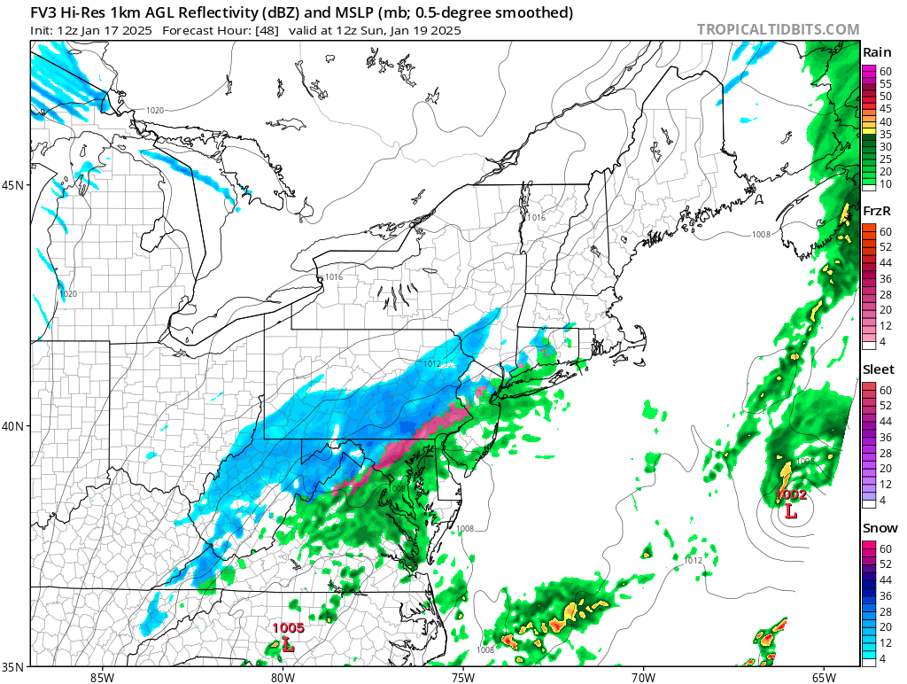
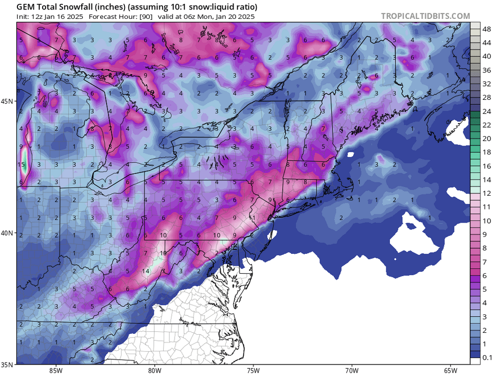
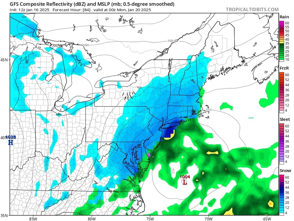
1/19 - The Weekend Roulette Wheel Thing
AmericanWxFreak replied to DDweatherman's topic in Mid Atlantic
0z FV3 had the boundary draped across SOMD lol -
1/19 - The Weekend Roulette Wheel Thing
AmericanWxFreak replied to DDweatherman's topic in Mid Atlantic

-
1/19 - The Weekend Roulette Wheel Thing
AmericanWxFreak replied to DDweatherman's topic in Mid Atlantic
He knows where you are gonna go........ to work -
1/19 - The Weekend Roulette Wheel Thing
AmericanWxFreak replied to DDweatherman's topic in Mid Atlantic
-
1/19 - The Weekend Roulette Wheel Thing
AmericanWxFreak replied to DDweatherman's topic in Mid Atlantic
-
January: Medium/ Long Range: May the Force be with Us....
AmericanWxFreak replied to Weather Will's topic in Mid Atlantic
It is currently experimental -
By far the strongest gusts of the storm in Port Charlotte right now. Impressive.
-
Getting rowdy here in Punta Gorda. Should be an interesting few hours.
-
https://x.com/B_conley25/status/1844061688578048343 wow…….
-
Still has the idea that the stronger storms end up north and weaker storms end up south.
-
Having a bit of trouble understanding the wind forecast for the i75 area of Port Charlotte assuming the landfall stays north of Siesta. We aren’t in a surge prone zone, over 25 feet above sea level. Seems like 10m wind maps don’t have much in this area but not sure if those accurately depict things. Any insight is appreciated and apologies for the IMBYness.
-
Parents live in Port Charlotte and are still fighting the legal battle to get damages from Ian repaired. Going to fly down there today to be with them in case of a shift and a last second need to head out. They are just too old to manage this stuff on their own anymore . Latest trends seem promising for not too much trouble down their way but with such a small cushion, I want to be down there just in case. Wonder what kind of weather I might end up getting to experience. From what I can see, the TB landfall should keep the majority of the wind to the north but maybe a few intense feeder bands swing through.
-
Call for 6 cars in the water off rt 40 in Ellicot City
-
The near constant cloud to cloud action is a nice touch
-
HRRR is insistent on them getting into the action overnight tonight too.