madwx
-
Posts
2,362 -
Joined
-
Last visited
Content Type
Profiles
Blogs
Forums
American Weather
Media Demo
Store
Gallery
Everything posted by madwx
-
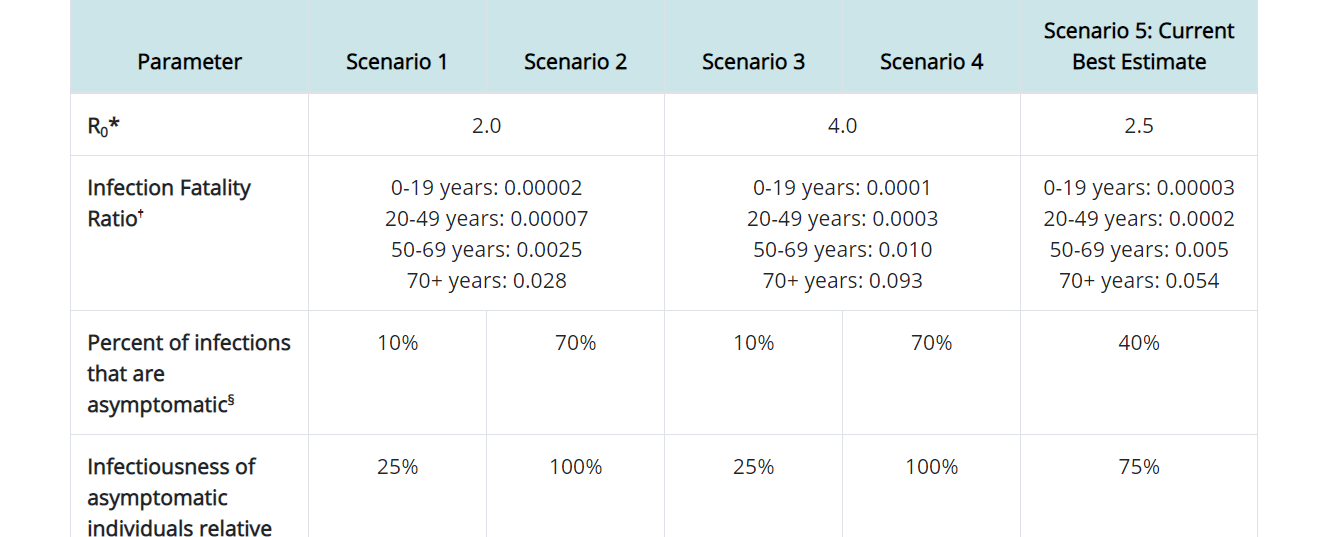
classic misinterpretation of the percentage or as some people like to say today, fake news. The actual data is in a ratio but this mainstream media org just slapped a percent at the end instead of moving the decimal two places to the right like you should when converting from a ratio to a percent. so it's really .003% for 0-19, 0.02% from 20-49, 0.5% for 50-69 and 5.4% for 70+.

-
Living in the upper midwest, especially if I had darker skin I would be taking daily vitamin D supplements. I'm as pale as a ghost but I'm still taking daily vitamin D.
-
An update on future risks now that we have Vicki) 1. The area of disturbed weather in the SW Gulf of Mexico has gotten more convectively active. Euro ensembles more bullish on this system as it meanders through the southern Gulf over the next week. 2. The latest wave to come off Africa looks fairly robust and slow development should occur as it moves across the Atlantic at a fairly low latitude. 3. Have to watch the area off the SE coast for tail end development from the cold front that will kick Sally out. Relative model consensus on an area of low pressure developing and this is a climatologically favored area. 4. Another wave will be coming off Africa later this week, though this one looks to be at a higher latitude so not sure how much potential for development there will be. 5. Very long range (post 9/21) but there is a chance for something out of the CAG off the coast of Nicaragua/Honduras.
-
Most likely Wilfred or a greek name. Vicky will probably go to 97L as it heads NW from the Cabo Verde islands
-
In addition to the 5 active areas in the atlantic right now(Paulette, Rene, TD 19, 95L in the central Atlantic and the recently added 97L in the far eastern Atlantic) there are a few more areas to keep an eye on. 1. A spin in the Gulf of Mexico S of New Orleans: This area is highlighted by the NHC and it will slowly move SW in the Gulf over the next few days. 2. An area of convection in the SW Gulf of Mexico: not much of anything at the surface but convection has been festering E of Veracruz for at least the past day now. 3. The Euro Ensembles are fairly consistent with a low latitude wave moving off of the Africa coast in the next couple days. 4. Any spinups along the ITCZ, especially just east of the Leeward Islands though this is much more of a long shot. And if that wasn't enough, the Euro Ensembles are already showing at least another wave or 2 moving off of Africa after this weekend.
-
2007-08 looks like a good analog. Especially if La Nina gets a little stronger than progged. Would take that winter and following severe weather season
-
Spain, France and a few other European countries are having a rough time again. They really took the foot off the gas for social distancing measures and are now paying the price.
-
The ride never ends
-

Phoenix Records its Hottest Summer on Record
madwx replied to donsutherland1's topic in Climate Change
Come on guys. It’s not man made climate change, it’s just man made changes to the environment that are making things warmer -
Phoenix Records its Hottest Summer on Record
madwx replied to donsutherland1's topic in Climate Change
In addition, Chicago, Tampa, Miami, Harrisburg and a few dozen other cities have also had their warmest summer on record -
Definitely a chance of tornadoes tomorrow in Wisconsin along the warm front
-
>trying to forecast 240 hours out >not using ensembles pick one
-
-
That's the tough thing about this. There is no telltale symptom that everyone has so for a good portion of people, without getting testing you have no idea if you have/had it.
-
if you get a test and are negative you don't have to quarantine. How would you know if you never really were negative?
-
also seems like that would funnel all students together. You'd think if they wanted some distancing they would let kids enter and exit in different areas
-
looks like there is a linked article that has a more recent update
-
Florida with an expected dip in positive cases due to testing closures for the hurricane. Deaths still staying high. Interesting impact on total statistics since many of the people with minor symptoms who can't get tested won't even test positive by the time the sites open back up
-
Michigan was hit harder earlier on when there was much less testing, so tons of cases were missed. Probably close to 1 million people in Michigan have had it already.
-
80% of middle aged people had lasting cardiovascular damage, their average BMI was 25. We don't know if this damage will go away with time and viruses usually do cause some short term cardiovascular damage but the damage from Covid is lasting longer than other diseases.
-
Average BMI in that study was 25.
-
https://jamanetwork.com/journals/jamacardiology/fullarticle/2768916 60% of middle aged people had cardiac inflammation after getting COVID. 20% with pericardial effusion. Average BMI 25. Fun. Fun fun fun.
-
Big differences between the HRRR and the 3kmNAM with the HRRR keeping both tonight's and tomorrow nights MCS much further north. The HRW suite seems to favor the further south propagation as well
-
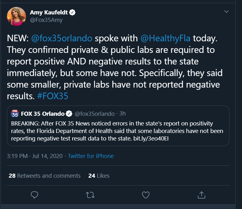
of course a group of people online have taken this as sign of a massive conspiracy. This reminds me of early on when Oklahoma was reporting only a tiny amount of tests and a very high positive rate because all private labs were only reporting positives. It made Oklahoma look like it was testing an order of magnitude people less than every other state ETA: confirmation of our theory
-
Crazy, just like watching the doctors slowly kill themselves in the operating room day after day. Not to mention the mass deaths in Asian countries from mask wearing. Not a time to trust the "experts."