Upstate Tiger
-
Posts
977 -
Joined
-
Last visited
Content Type
Profiles
Blogs
Forums
American Weather
Media Demo
Store
Gallery
Everything posted by Upstate Tiger
-

Mid to Long Range Discussion ~ 2024
Upstate Tiger replied to buckeyefan1's topic in Southeastern States
-
Mid to Long Range Discussion ~ 2024
Upstate Tiger replied to buckeyefan1's topic in Southeastern States
Yep. Until this changes, no bueno for SE winter lovers... -
Mid to Long Range Discussion ~ 2024
Upstate Tiger replied to buckeyefan1's topic in Southeastern States
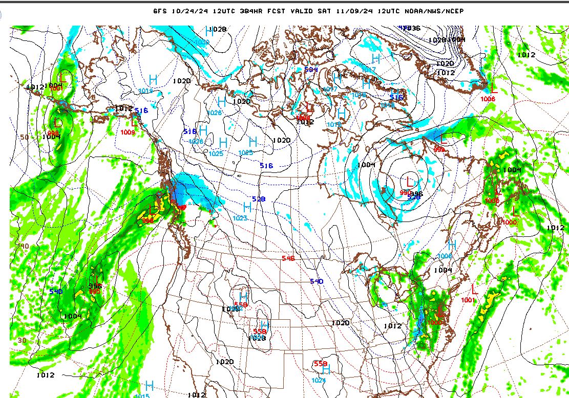
You could basically cut and past the image below from the past few winters. You would think the parade of storms crashing into the Pacific NW and BC would cease at least for 1 winter. This is for 11/13 but you can pick any date.
-
Mid to Long Range Discussion ~ 2024
Upstate Tiger replied to buckeyefan1's topic in Southeastern States
I think I’m going to go George Constanza and do the opposite this winter. In other words, I’m going to project no hope, and constantly reject any modeling that shows anything but AN temps. So, I agree with your post, November will be a torch. December and January likewise. There will be no snow south of the Mason Dixon line below 5,000’. -
Mid to Long Range Discussion ~ 2024
Upstate Tiger replied to buckeyefan1's topic in Southeastern States
I remember that storm. I was at Myrtle Beach. Got 5” and it was gone by breakfast. -
Mid to Long Range Discussion ~ 2024
Upstate Tiger replied to buckeyefan1's topic in Southeastern States
I grew up in the upstate of SC. 76-83 were all awesome for snow lovers. Became more and more sporadic after that run. Difference then was cold would last for long periods of time and snow would linger for weeks. The last comparable winter would be 95-96 for the upstate. -
Mid to Long Range Discussion ~ 2024
Upstate Tiger replied to buckeyefan1's topic in Southeastern States
Just read where Mt. Fuji is without a snowcap going into November for the first time since official records started being kept 130 years ago. It normally has a snow cap by October 5. This fall is reminding me a lot of 2016 -
Mid to Long Range Discussion ~ 2024
Upstate Tiger replied to buckeyefan1's topic in Southeastern States
I know I know...but it's all we've got to work with right now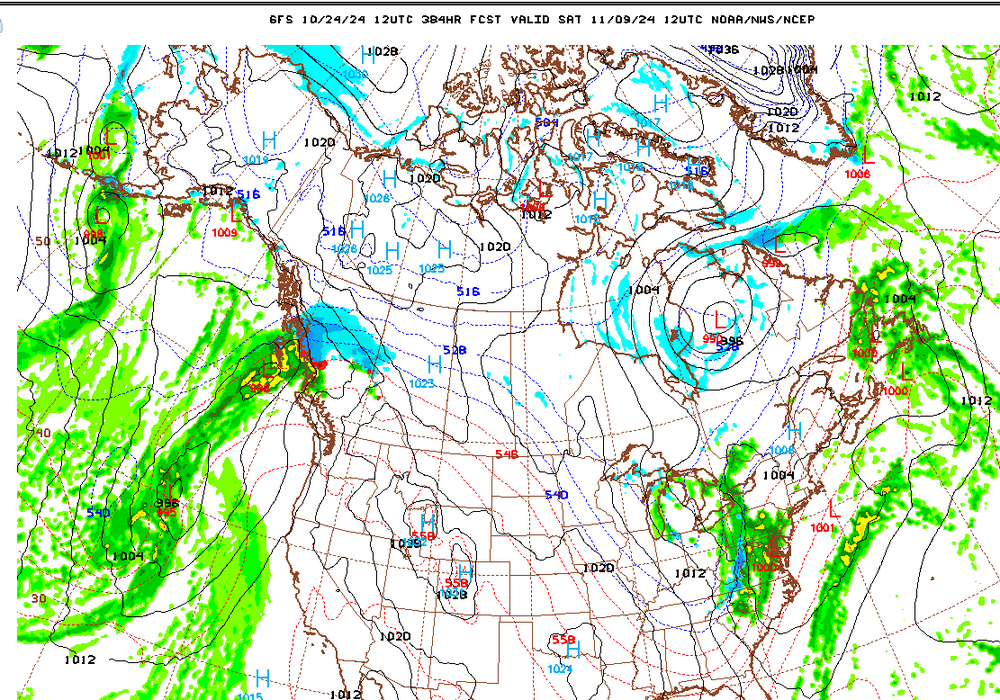
-
Mid to Long Range Discussion ~ 2024
Upstate Tiger replied to buckeyefan1's topic in Southeastern States
Big coastal storm being shown for late week 1 in November for several runs in a row. Maybe can usher in a pattern change. Lots of cold air during this period over western Canada and the NW US, typical of Nina. -
Hit the freezing mark for the first time this morning.
-
After this cool down this week, Indian Summer looks to return until the end of the month. Mild and dry.
-
39 this morning in West Lincoln County. First morning under 40.
-
Mid to Long Range Discussion ~ 2024
Upstate Tiger replied to buckeyefan1's topic in Southeastern States
Latest from CPC...still predicting a weak La Nina although we remain in a neutral enso. https://www.cpc.ncep.noaa.gov/products/analysis_monitoring/enso_advisory/ensodisc.shtml -
Mid to Long Range Discussion ~ 2024
Upstate Tiger replied to buckeyefan1's topic in Southeastern States
My wife and I have been praying constantly for you guys! Reach out via email if I can help with anything. Stay strong -
Mid to Long Range Discussion ~ 2024
Upstate Tiger replied to buckeyefan1's topic in Southeastern States
You know I wanted to post something about late next week but conscience got the best of me. Hard to root for cold weather right now or talk about leaves turning. -
Wow. 911MBs. Havent had a chance to look at satellite today. Is he geographically as large as Katrina or Helene?
-
That’s good for Florida.
-
Why does the NHC project so much weakening before landfall. Is it supposed to undergo a lot of sheer or dry air?
-
Never forget, beauty is in the eye of the beholder
-
Will the dam hold with those kind of rates? I remember the stories from my grandmother who lived on the Keowee River as a kid and the Toxaway dam failed.
-
Be interesting to see how low she goes. Anything in the 940s is a really dangerous storm. She still has several hours before landfall to undergo rapid intensification.
-
Yep. Opal was a very strong storm. Differene is that is was very compact like Camille.
-
If I had told you a couple of years ago "you will be under a Tropical Storm Watch before you are under a Winter Storm Watch again" I would have been horse laughed off the site
- 757 replies
-
- 13
-

-

-

-

-

-
Mid to Long Range Discussion ~ 2024
Upstate Tiger replied to buckeyefan1's topic in Southeastern States
Today's ENSO update from IRI: The CPC ENSO Outlook predicts a clear preference for La Niña onset in Sep-Nov (66% chances) with continuation until Jan-Mar, 2025 (57% chances), and then a return to ENSO-neutral state during boreal spring of 2025. In contrast, the objective IRI ENSO forecasts show late, weak and temporary La Niña conditions in Oct-Dec, and Nov-Jan. The forecasts then show a return to ENSO-neutral conditions that remain dominant during the boreal winter and spring of 2025. https://iri.columbia.edu/our-expertise/climate/forecasts/enso/current/ -
57 in west Lincoln this morning. Very nice!