Upstate Tiger
-
Posts
984 -
Joined
-
Last visited
Content Type
Profiles
Blogs
Forums
American Weather
Media Demo
Store
Gallery
Everything posted by Upstate Tiger
-
CPC predicting rapid return to Nina conditions this summer and increasing through fall. That makes 4 out of 5 right? Can we ever get a neutral anymore?
-

Mid to Long Range Discussion ~ 2024
Upstate Tiger replied to buckeyefan1's topic in Southeastern States
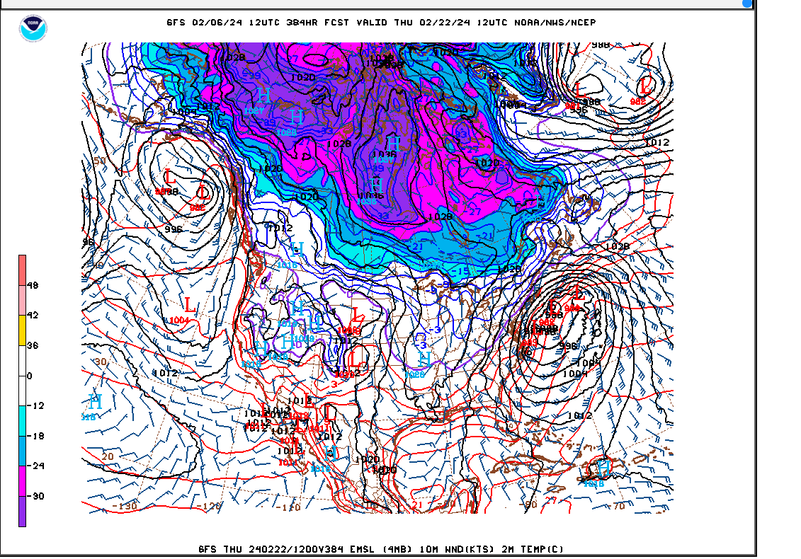
LOL...I had this copied and ready to paste! Love seeing the purple over the SE... -
Mid to Long Range Discussion ~ 2024
Upstate Tiger replied to buckeyefan1's topic in Southeastern States
We won in Chapel Hill last night for the second time in 62 years. At this point, I believe anything is possible. -
Mid to Long Range Discussion ~ 2024
Upstate Tiger replied to buckeyefan1's topic in Southeastern States
Wished you were right. Has been no time fittin for golf on the weekends since November but it looks like plenty of cold to me.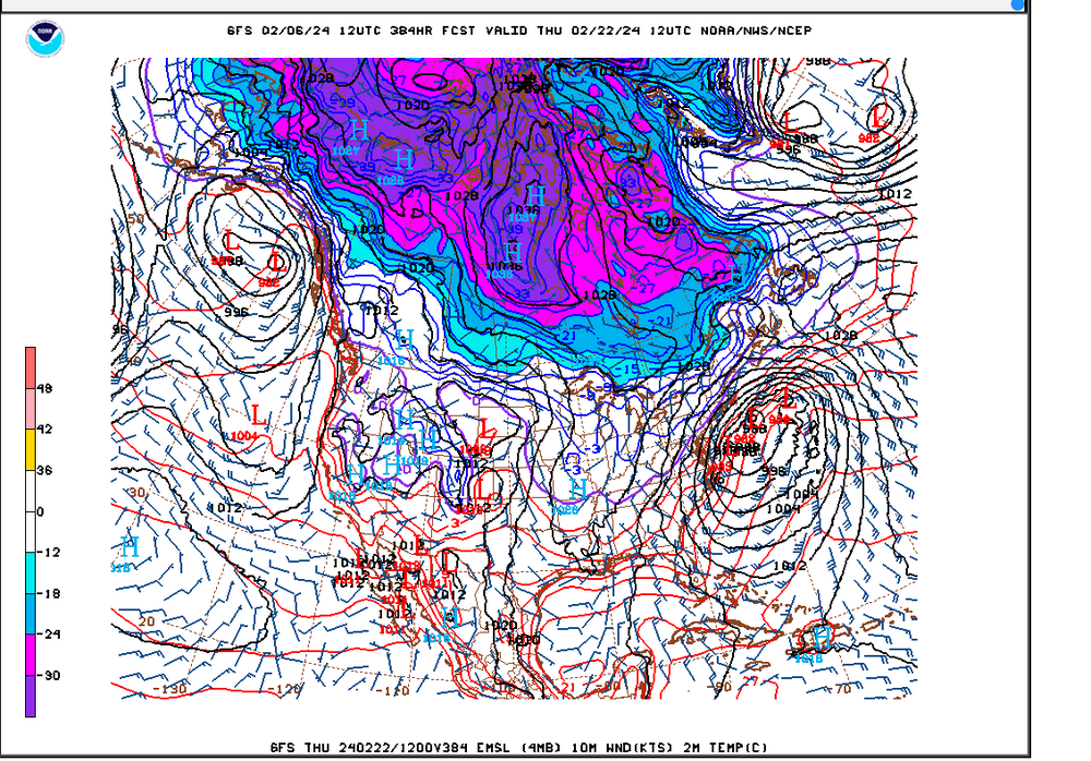
-
Mid to Long Range Discussion ~ 2024
Upstate Tiger replied to buckeyefan1's topic in Southeastern States
That analogy certainly makes sense and I do not get paid to forecast the weather. However, looking beyond the 7-10 range looks like there is plenty of arctic air in Canada, northern tier, and this side of the hemisphere. Guess I am a little puzzled what he is looking at to completely call off winter? -
Mid to Long Range Discussion ~ 2024
Upstate Tiger replied to buckeyefan1's topic in Southeastern States
That's all we've got ATM. It's kinda like at the end of the night when you know the bar is going to close soon and the only girl left in the place is one who looks pretty good sitting way down at the other end of the bar. -
Mid to Long Range Discussion ~ 2024
Upstate Tiger replied to buckeyefan1's topic in Southeastern States
This winter really blows. Can't believe we are going to be shut out again. It's never going to snow in the SE again. There, that should help. -
Mid to Long Range Discussion ~ 2024
Upstate Tiger replied to buckeyefan1's topic in Southeastern States
78 and 83 were pretty memorable in the upstate of SC -
Mid to Long Range Discussion ~ 2024
Upstate Tiger replied to buckeyefan1's topic in Southeastern States
71 forecast here for Super Bowl Sunday. Maybe we'll finally get some decent weather for our annual Super Bowl Sunday backwards par 3 tournament. May have to break out shorts and sunscreen. -
Mid to Long Range Discussion ~ 2024
Upstate Tiger replied to buckeyefan1's topic in Southeastern States
LOL...The Rio Grande, Corpas Christi, and South Padre Island are the places to be! Plenty of time for this to trend north and east
-
Mid to Long Range Discussion ~ 2024
Upstate Tiger replied to buckeyefan1's topic in Southeastern States
In all seriousness I think we will start seeing fantasy storms showing up over the next several days for this period. -
Mid to Long Range Discussion ~ 2024
Upstate Tiger replied to buckeyefan1's topic in Southeastern States
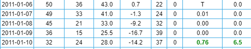
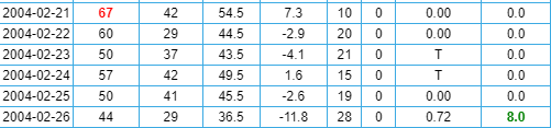
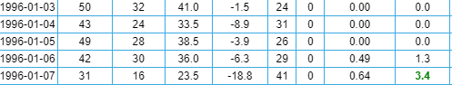
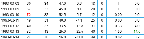
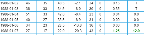
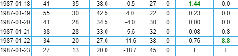
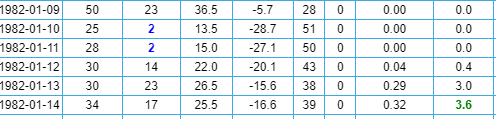
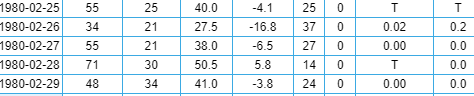
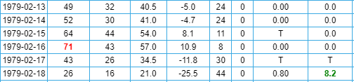
There's been some talk about the correlation and timing of cold in the SE to winter storms. Just for fun, I went back and looked at some memorable winter storms to see what temps looked like in the days leading up to these storms. This is for the Greenville, SC area. The far right column is new snow depth. With the exception of 1982, the cold air arrives within 24 hours of the onset of the storm. February 2014 January 2011 February 2004 January 1996 March 1993 January 1988 January 1987 January 1982 March 1980 February 1979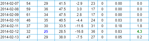
-
Mid to Long Range Discussion ~ 2024
Upstate Tiger replied to buckeyefan1's topic in Southeastern States
Brick. Have you tried to play golf in March the last few years? I swear I saw that mammoth from Ice Age walking across the 6th fairway last year. Good to hear from you BTW. -
Mid to Long Range Discussion ~ 2024
Upstate Tiger replied to buckeyefan1's topic in Southeastern States
Agree. Orientation of the cold in February is much more conducive to winter weather on this side of the apps. Of course it changes every 24 hours which is probably a good sign. -
2023-2024 Fall/Winter Mountain Thread
Upstate Tiger replied to The Alchemist's topic in Southeastern States
Awesome pics guys!! Keep sharing. And give us some temp updates too. -
Mid to Long Range Discussion ~ 2024
Upstate Tiger replied to buckeyefan1's topic in Southeastern States
Yeah, I hear you. If you look at the long range link I sent today, and I'm not the expert others are, it would seem to me maybe the 5th, which is start of week 2, would be the earliest for a true pattern change. However, winter is a fast flow so things can change fast. -
Mid to Long Range Discussion ~ 2024
Upstate Tiger replied to buckeyefan1's topic in Southeastern States
Looking at the long range out 14 days to first week of Feb., the cold in Canada looks better today and looked even better overnight. NAO looks to stay positive but so does PNA. MJO looks to maybe get through 6 and some plots have it going into 7. Still feel like we get our chance in February. https://www.cpc.ncep.noaa.gov/products/precip/CWlink/pna/nao_index_mrf.shtml
-
Mid to Long Range Discussion ~ 2024
Upstate Tiger replied to buckeyefan1's topic in Southeastern States
Welp. This season started with such hope. Maybe ranking among the best of all time. 79-80 and even 95-96 were mentioned when talking about this year. However, we’re headed into late January and we suck again having lost 4/5. Oh and this winter sucks too. Hoping for that February turnaround and great March for both. -
Mid to Long Range Discussion ~ 2024
Upstate Tiger replied to buckeyefan1's topic in Southeastern States
Looking at the longrange on the 12Z GFS today is not good for us snow lovers in the SE. Any cold intrusions after this weekend look sparse going into the first week of February. Remains to be seen if the cold returns as moldeled earlier. NAO looks to head positive, PNA stays positive (good), but MJO is headed to 6 before maybe COD. Not the trends we want. -
Mid to Long Range Discussion ~ 2024
Upstate Tiger replied to buckeyefan1's topic in Southeastern States
Yep. It stinks. Snow drought is probably an appropriate term. The 1950s had a similar snow drought in the SE. Still think Feb holds some opportunities -
Mid to Long Range Discussion ~ 2024
Upstate Tiger replied to buckeyefan1's topic in Southeastern States
I know it's frustrating right now and it's been a frustrating couple of years for snow lovers but wall to wall cold from December to March just does not happen here. The coldest month on record at GSP is Janaury 1977 and there were days in the 50's and even a 55 on Janaury 27. The coldest February on record at GSP is February 1980. We had 8" of snow that month with 3 events. We also had 4 days in the 70's including a 76 a few days before March 1, 1980. Anyone around the Carolinas then remembers what happened March 1-2, 1980. -
Mid to Long Range Discussion ~ 2024
Upstate Tiger replied to buckeyefan1's topic in Southeastern States
During the moderation the last 2 weeks of the month (hopefully get some golf in), Canada will be resupplying with cold air. I actually liked the orientation of the high pressure better on the 0Z for the first week of February. The 06Z was further west. Nevertheless, cold should be poised to move south and east.
-
Mid to Long Range Discussion ~ 2024
Upstate Tiger replied to buckeyefan1's topic in Southeastern States
Yep. The 18z is no bueno for Monday and Tuesday. -
Mid to Long Range Discussion ~ 2024
Upstate Tiger replied to buckeyefan1's topic in Southeastern States
I guess I need to go back and look at the 12Z GFS again because I don't get the gnashing of teeth . But I'm old so I may have been looking a tic tok video. -
Mid to Long Range Discussion ~ 2024
Upstate Tiger replied to buckeyefan1's topic in Southeastern States
Correct! That's the place to be in this set up.