

Upstate Tiger
-
Posts
984 -
Joined
-
Last visited
Content Type
Profiles
Blogs
Forums
American Weather
Media Demo
Store
Gallery
Everything posted by Upstate Tiger
-
One thing from overnight that is a bit bothersome is the delay showing up in the last few runs. Would really like to see that wave follow the 19th storm 24-48 hours later versus 96 hours. Nevertheless, still have a signal and models likely don’t have a handle on timing of the specific pieces of energy.
-
I am just glad that the 12z suite was awesome and happy hour was not too happy. When it’s the opposite, we never seem to score.
-
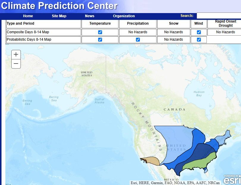
Nice hazard map from the CPC this afternoon for next week.
-
Proabably Saturday 1/17/92. Did not get a drop in the upstate while central Ga got 5"
-
That was the overruning storm I alluded to yesterday. Was in the teens in the Carolinas during the storm with record snow and stayed cold for about a week afterword.
-
Somebody's in for a nice surprise on Sunday
-
Would love to see another January 88 overrunning storm with an arctic front draped across the south. 14” of snow and temps in the mid teens. It was one for the ages.
-
Yep. That setup reminds me of Presidents Day 1979. Would love to see just one more of those in my lifetime.
-
Just woke up from my Sunday afternoon nap. Wife walked in and caught me looking at the Euro. Now I have a lot of splaining to do.
-

1/10-11 super awesome winter SE OBS thread
Upstate Tiger replied to strongwxnc's topic in Southeastern States
Back to light snow here. -
1/10-11 super awesome winter SE OBS thread
Upstate Tiger replied to strongwxnc's topic in Southeastern States
Gone back from rain to heavy sleet here and 28. -
1/10-11 super awesome winter SE OBS thread
Upstate Tiger replied to strongwxnc's topic in Southeastern States
We’ve gone ever to rain from snow in West Lincoln. Got about 1.5” before the transition. -
1/10-11 super awesome winter SE OBS thread
Upstate Tiger replied to strongwxnc's topic in Southeastern States
Snowing in West Lincoln! -
Good stuff. Thanks.
-
Yes, there is a pretty strong line of thunderstorms that have developed off shore. Don't know if it is enought to impact our storm at this point. Will just have to watch it.
-
While we await the arrival of today's winter weather, I did a quick check on the extended forecasts. I am sensing a major ice storm in our future.
-
GSP AFD stating some areas along and north of 85 may get 2-3” of sleet after the initial burst of snow. Wowser. Great for sledding. Terrible for driving.
-
Yep. The GFS was a step in the right direction for those of us wanting more snow above 85.
-
Well…my roads are brined and I’m under a WSW starting at 700AM Friday. That’s already better than the last couple of years.
-
SC and NC about to be NAM’d
-
Blocking, blocking, my kingdom for some blocking
-
This is what to look for. Got to get back to negative tilt sooner. if not, I’ve seen this too many times in my 50 years of winter weather watching, there will be a lot of disappointed folks.
-
GSP. As we all saw last night, less phasing less precip. Still early for specifics. As of 250 am Wednesday: A cold and very dry air mass will remain in place in association with arctic surface high pressure during the first half of the short term. A short wave trough will then eject from Texas Fri/Fri night, with the wave becoming increasingly dampened and vorticity increasingly channeled as it progresses across the Southeast. An attendant cyclone will track along the Gulf Coast Friday before pushing off the South Carolina Coast early Saturday. This track will allow frontogenetical forcing to wring out precip across the western Carolinas and northeast Georgia by Friday afternoon before tapering off Friday night, with categorical PoPs of 80-90% warranted across the entire forecast area during this time frame. In terms of precip types and amounts...the overall trend in the consensus of global and short term guidance is toward less phasing of the southern and northern branches of the upper jet, and toward a more suppressed/farther south/slightly weaker and colder scenario for the Southeast.
-
I’m hoping to kick back Friday night and watch the OSU destroy the horns while the snow piles up outside.
-
Once we get inside 24 hours you can just about go to the bank with the thermals on the NAM. I’m holding my breath to that late Thursday night NAM run. No doubt we have a storm but how much of what is still in question.


