

Upstate Tiger
-
Posts
984 -
Joined
-
Last visited
Content Type
Profiles
Blogs
Forums
American Weather
Media Demo
Store
Gallery
Everything posted by Upstate Tiger
-

February 19-20 Major Winter Storm Threat
Upstate Tiger replied to NorthHillsWx's topic in Southeastern States
https://forecast.weather.gov/product.php?site=NWS&issuedby=GSP&product=AFD&format=ci&version=1&glossary=1&highlight=off -
February 19-20 Major Winter Storm Threat
Upstate Tiger replied to NorthHillsWx's topic in Southeastern States
Yeah but we can we really trust the Canadian? They booed our national anthem. -
February 19-20 Major Winter Storm Threat
Upstate Tiger replied to NorthHillsWx's topic in Southeastern States
Even the blue turd is getting excited. I’m going to buy my milk and bread now. -
February 19-20 Major Winter Storm Threat
Upstate Tiger replied to NorthHillsWx's topic in Southeastern States
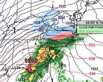
For you young ones, this kind of storm occurred often in the 70s and 80s except we didn’t have models or American Wx. Only Charlie Gertz on WYFF or Dr Joe on the radio to give us a 2 day heads up. LONG TERM /TUESDAY NIGHT THROUGH SATURDAY/... As of 100 PM Sat: Upper low will cut off over the northern Plains by Wednesday morning, with a low amplitude shortwave trough accelerating ahead of it and crossing the Mid-South Wednesday. This latter feature will advance to the NC/VA coast by early Thursday. Global models continue to depict Miller A-type sfc low near the central Gulf Coast at 12z Wed, which tracks generally to our south through Wednesday evening. Models appear to be in decent agreement on this general evolution. 12z cycle ECMWF, along with both EC and GFS Ensemble means, have trended toward a slightly faster deepening of the low although the track has not changed much. The closed upper low will be associated with a 1050+ mb high over eastern Montana and vicinity; ridging will extend to the Mid-Atlantic Coast and confluence downstream of the trough may lead to a small closed high to our north supporting CAD on Wed and a very dry sfc layer. The Miller-A is likely to bring precip shield over the area on Wed. The critical difference among models appears to be how well the precip overcomes what may be exceptionally dry air at onset, and how temps respond. There are slight differences in timing that limit confidence, but these temperature discrepancies are the main factor in a low-confidence forecast, at least in the sense of precip type trends or overall impact. The presence of ice nuclei does not appear to be an issue at the onset of precip, which most likely will not occur until after daybreak Wednesday; PoPs are mainly in the 10-30% range Tuesday night, reflecting possibility of earlier onset. The most plausible middle-ground scenario, taking this into account, is for rain or snow early in the event, even after PoPs ramp up into the likely to categorical range (from SW to NE) during the day Wed. With low confidence on temperature, have tried to minimize the expanse of subfreezing temps early in the event, leaving mention as a rain/snow mix in much of the CWA where temps hover just above freezing. A warm nose may also come into play and some sleet could mix in at this time. As the low passes the area Wed evening and drying occurs aloft, p-type changes to FZRA in portions of the Piedmont where temps fall below freezing; wraparound moisture keeps snow going over the mountains. Most precip will end Wednesday night, but NW flow snow could continue Thu along the TN border. The remainder of the forecast will be dry and cold as the Arctic air remains over the Southern US. Min/max temps will be 15-20 below normal Thu-Fri. -
I only looked at the simulated radar but the GFS looked better on this run.
-
Euro is another flew blown Nor'easter right up the coast. The mountains likely to get a big NWF event out of that track.
-
Yep. The 540 is in VA surprise. Just a bit slower and we're in business..
-
Euro better than GFS. 1057 high over the Great Basin LOL
-
Exactly!
-
We beat Kentucky, Duke, and UNC in the same year. Don’t tell me it’s impossible to get snow outside the mountains.
-
I see my annual American Wx dues were deducted out of my account today. If I do not see 6”-8” of snow IMBY by next weekend I am afraid I will be requesting a refund.
-
Glad I waited on the Euro.
-
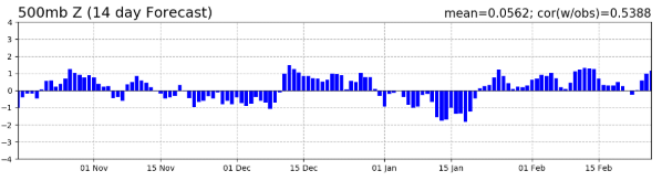
NAO forecast from this morning. You can see the dip for next week.
-

-
Next period to watch for NC is end of next week. Globals keep hinting at a storm further south.
-
Yep the next 2 weeks will feel wintry. Remains to be seen if there will be any snow or ice in the SE but we’re in for a cool period.
-
When the natives get restless and this place turns into Lord of the Flies, one needn’t look at the models.
-
Central Park is going to look a lot different in 10 days than it looks today. They have at least 3 pretty big events headed their way.
-
Really liked the 12z GFS. Interested in the Euros interpretation.
-
Presidents’ Day storm 1979 says hello! Warm leading up to storm. Warm by the end of the week after the storm.
-
Overnight Euro and 06z GFS would suggest a candlelight dinner maybe appropriate for Valentines Day.
-
Thanks for sharing! I love it when someone actually shares meteorology. Keep in mind, metereology and climatology are two different things...
-
How often do you have to cut it?
-
I can say with a fair amount of certainty that one day we will probably see another Miller A with widespread snow in the SE. I may not be around then, but it will be awesome.
-
Watching the second week of February. Cold is on the move from Canada and NAO looks to be moving toward negative territory.


